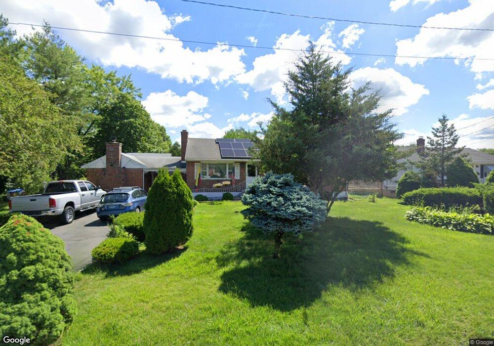
76 Cummings Ave Wethersfield, CT 06109
Estimated Value: $379,000 - $384,666
3
Beds
2
Baths
1,544
Sq Ft
$247/Sq Ft
Est. Value
About This Home
This home is located at 76 Cummings Ave, Wethersfield, CT 06109 and is currently estimated at $381,667, approximately $247 per square foot. 76 Cummings Ave is a home located in Hartford County with nearby schools including Emerson-Williams School, Silas Deane Middle School, and Wethersfield High School.
Ownership History
Date
Name
Owned For
Owner Type
Purchase Details
Closed on
Apr 16, 2025
Sold by
Ballestas Giussepe R
Bought by
Ballestas Rafael A
Current Estimated Value
Purchase Details
Closed on
Aug 12, 2020
Sold by
Ballestas Rosa M and Ballestas Arnoldo
Bought by
Ballestas Giussepe R
Purchase Details
Closed on
Dec 30, 2009
Sold by
Witwicki Witold John and Domenick Christine W
Bought by
Ballestas Arnoldo and Ballestas Rosa M
Home Financials for this Owner
Home Financials are based on the most recent Mortgage that was taken out on this home.
Original Mortgage
$206,552
Interest Rate
4.85%
Purchase Details
Closed on
Dec 29, 1999
Sold by
Witwicki Witold and Witwicki Stanislawa
Bought by
Witwicki John and Domenick Christine W
Home Financials for this Owner
Home Financials are based on the most recent Mortgage that was taken out on this home.
Original Mortgage
$120,000
Interest Rate
4%
Create a Home Valuation Report for This Property
The Home Valuation Report is an in-depth analysis detailing your home's value as well as a comparison with similar homes in the area
Home Values in the Area
Average Home Value in this Area
Purchase History
| Date | Buyer | Sale Price | Title Company |
|---|---|---|---|
| Ballestas Rafael A | -- | None Available | |
| Ballestas Giussepe R | -- | None Available | |
| Ballestas Giussepe R | -- | None Available | |
| Ballestas Arnoldo | $215,000 | -- | |
| Ballestas Arnoldo | $215,000 | -- | |
| Witwicki John | $120,000 | -- | |
| Witwicki John | $120,000 | -- |
Source: Public Records
Mortgage History
| Date | Status | Borrower | Loan Amount |
|---|---|---|---|
| Previous Owner | Witwicki John | $206,552 | |
| Previous Owner | Witwicki John | $120,000 |
Source: Public Records
Tax History
| Year | Tax Paid | Tax Assessment Tax Assessment Total Assessment is a certain percentage of the fair market value that is determined by local assessors to be the total taxable value of land and additions on the property. | Land | Improvement |
|---|---|---|---|---|
| 2025 | $9,501 | $230,500 | $69,270 | $161,230 |
| 2024 | $7,233 | $167,360 | $70,660 | $96,700 |
| 2023 | $6,992 | $167,360 | $70,660 | $96,700 |
| 2022 | $6,875 | $167,360 | $70,660 | $96,700 |
| 2021 | $6,807 | $167,360 | $70,660 | $96,700 |
| 2020 | $6,810 | $167,360 | $70,660 | $96,700 |
| 2019 | $6,818 | $167,360 | $70,660 | $96,700 |
| 2018 | $6,839 | $167,700 | $69,100 | $98,600 |
| 2017 | $6,669 | $167,700 | $69,100 | $98,600 |
| 2016 | $6,463 | $167,700 | $69,100 | $98,600 |
| 2015 | $6,404 | $167,700 | $69,100 | $98,600 |
| 2014 | $6,161 | $167,700 | $69,100 | $98,600 |
Source: Public Records
Map
Nearby Homes
- 1 Bristol St
- 19 Albert Ave
- 55 Rutledge Rd
- 1 Brussels Ave
- 295 Ridge Rd Unit 8
- 144 Brown St
- 192 Wolcott Hill Rd
- 219-221 Jordan Ln
- 173 Timber Trail
- 273 Forest Dr
- 20 Forest Dr
- 129 Goff Rd
- 23 Hillcrest Ave
- 764 Ridge Rd
- 64 Cromwell St
- 208 Mountain St
- 62 Schoolhouse Crossing
- 18 Avalon Place
- 107 Harmund Place
- 15 Potter Crossing
Your Personal Tour Guide
Ask me questions while you tour the home.