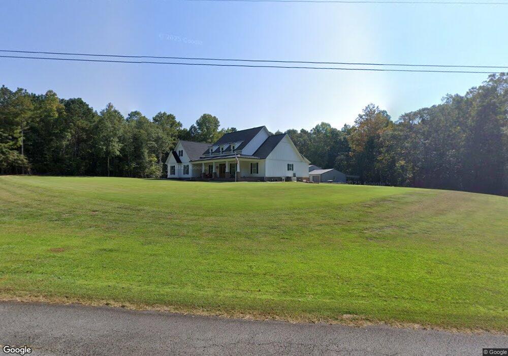
76 Lee Rd Carrollton, GA 30117
Estimated Value: $394,000 - $764,632
4
Beds
4
Baths
2,880
Sq Ft
$193/Sq Ft
Est. Value
About This Home
This home is located at 76 Lee Rd, Carrollton, GA 30117 and is currently estimated at $556,877, approximately $193 per square foot. 76 Lee Rd is a home located in Carroll County with nearby schools including Central Elementary School, Central Middle School, and Central High School.
Ownership History
Date
Name
Owned For
Owner Type
Purchase Details
Closed on
May 13, 2020
Sold by
Kemp Mark A
Bought by
Kemp Terry Kevin and Kemp Cynthia Dawn
Current Estimated Value
Purchase Details
Closed on
Jul 2, 2008
Sold by
Kemp Carol A
Bought by
Carroll County
Purchase Details
Closed on
May 29, 1997
Sold by
Kemp Carol A
Bought by
Kemp Carol A Mrs
Purchase Details
Closed on
Jan 1, 1988
Bought by
Kemp Carol A
Create a Home Valuation Report for This Property
The Home Valuation Report is an in-depth analysis detailing your home's value as well as a comparison with similar homes in the area
Home Values in the Area
Average Home Value in this Area
Purchase History
| Date | Buyer | Sale Price | Title Company |
|---|---|---|---|
| Kemp Terry Kevin | -- | -- | |
| Kemp Terry Kevin | -- | -- | |
| Carroll County | -- | -- | |
| Kemp Carol A Mrs | -- | -- | |
| Kemp Carol A | -- | -- |
Source: Public Records
Tax History
| Year | Tax Paid | Tax Assessment Tax Assessment Total Assessment is a certain percentage of the fair market value that is determined by local assessors to be the total taxable value of land and additions on the property. | Land | Improvement |
|---|---|---|---|---|
| 2025 | $1,672 | $275,903 | $42,451 | $233,452 |
| 2024 | $1,843 | $297,604 | $42,451 | $255,153 |
| 2023 | $1,843 | $60,991 | $33,961 | $27,030 |
| 2022 | $1,115 | $44,439 | $22,641 | $21,798 |
| 2021 | $1,023 | $39,910 | $18,112 | $21,798 |
| 2020 | $760 | $29,600 | $16,466 | $13,134 |
| 2019 | $259 | $29,600 | $16,466 | $13,134 |
| 2018 | $272 | $42,842 | $13,382 | $29,460 |
| 2017 | $275 | $42,842 | $13,382 | $29,460 |
| 2016 | $275 | $42,842 | $13,382 | $29,460 |
| 2015 | $277 | $40,920 | $14,708 | $26,212 |
| 2014 | $279 | $40,920 | $14,708 | $26,212 |
Source: Public Records
Map
Nearby Homes
- 64 Wooddale Ln
- 124 Wooddale Ln
- 0 Sunny Brook Ln Unit 1529051
- 671 Old Camp Church Rd
- 678 Old Camp Church Rd
- 345 Piney Grove Rd
- 80 Camp Ln
- 0 Bonner Rd Unit 10635754
- 420 Piney Grove Rd
- 120 N Fairlawn Dr
- 2855 W Highway 166
- 105 Summerfield Place Dr
- 106 Summerfield Place Dr
- 111 Summerfield Place Dr
- 115 Summerfield Place Dr
- 110 Summerfield Place Dr
- 112 Summerfield Place Dr
- 116 Summerfield Place Dr
- 118 Summerfield Place Dr
- 46 W Greenwood Dr
- 59 Boulder Dr
- 81 Boulder Dr
- 158 Lee Rd
- 62 Boulder Dr
- 78 Boulder Dr
- 46 Boulder Dr
- 37 Boulder Dr
- 55 Lee Rd
- 95 Boulder Dr
- 95 Boulder Dr
- 501 Old Camp Church Rd Unit B
- 501 Old Camp Church Rd
- 135 Lee Rd
- 150 Lee Rd
- 25 Boulder Dr
- 22 Wooddale Ln
- 515 Old Camp Church Rd
- 34 Wooddale Ln
- 676 Tyus Carrollton Rd
- 632 Tyus Carrollton Rd
Your Personal Tour Guide
Ask me questions while you tour the home.