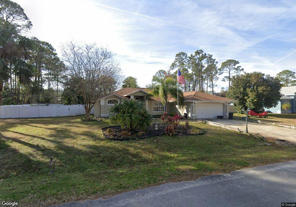
76 Port Royal Dr Palm Coast, FL 32164
Estimated Value: $315,000 - $370,000
--
Bed
2
Baths
1,926
Sq Ft
$180/Sq Ft
Est. Value
About This Home
This home is located at 76 Port Royal Dr, Palm Coast, FL 32164 and is currently estimated at $347,535, approximately $180 per square foot. 76 Port Royal Dr is a home located in Flagler County with nearby schools including Rymfire Elementary School, Buddy Taylor Middle School, and Flagler-Palm Coast High School.
Ownership History
Date
Name
Owned For
Owner Type
Purchase Details
Closed on
Apr 5, 2022
Sold by
Reardon Sr James A
Bought by
Thornhill Catherine and Reardon James A
Current Estimated Value
Purchase Details
Closed on
Nov 27, 1996
Sold by
Reardon James and Reardon Catherine
Bought by
Reardon James A and Reardon Catherine R
Home Financials for this Owner
Home Financials are based on the most recent Mortgage that was taken out on this home.
Original Mortgage
$80,000
Interest Rate
7.87%
Purchase Details
Closed on
Jul 23, 1996
Sold by
Kassar George J and Kassar Alexandra M
Bought by
Reardon James and Reardon Catherine
Create a Home Valuation Report for This Property
The Home Valuation Report is an in-depth analysis detailing your home's value as well as a comparison with similar homes in the area
Home Values in the Area
Average Home Value in this Area
Purchase History
| Date | Buyer | Sale Price | Title Company |
|---|---|---|---|
| Thornhill Catherine | -- | Cuff Robert G | |
| Reardon James A | -- | -- | |
| Reardon James | $9,000 | -- |
Source: Public Records
Mortgage History
| Date | Status | Borrower | Loan Amount |
|---|---|---|---|
| Previous Owner | Reardon James A | $80,000 |
Source: Public Records
Tax History Compared to Growth
Tax History
| Year | Tax Paid | Tax Assessment Tax Assessment Total Assessment is a certain percentage of the fair market value that is determined by local assessors to be the total taxable value of land and additions on the property. | Land | Improvement |
|---|---|---|---|---|
| 2024 | $1,551 | $130,196 | -- | -- |
| 2023 | $1,551 | $126,404 | $0 | $0 |
| 2022 | $1,523 | $122,723 | $0 | $0 |
| 2021 | $1,493 | $119,148 | $0 | $0 |
| 2020 | $1,486 | $117,503 | $0 | $0 |
| 2019 | $1,453 | $114,861 | $0 | $0 |
| 2018 | $1,438 | $112,719 | $0 | $0 |
| 2017 | $1,397 | $110,401 | $0 | $0 |
| 2016 | $1,359 | $108,130 | $0 | $0 |
| 2015 | $1,360 | $107,378 | $0 | $0 |
| 2014 | $1,363 | $106,526 | $0 | $0 |
Source: Public Records
Map
Nearby Homes
- 25 Port Echo Ln
- 23 Portia Ln
- 7 Portia Ln
- 17 Porter Ln
- 2 Porter Ln
- 9 Pierce Ln
- 30 Piedmont Dr
- 132 Point Pleasant Dr
- 5 Port Echo Place
- 1 Piermount Ln
- 27 Pier Ln
- 136 Point Pleasant Dr
- 9 Port Royal Dr
- 39 Port Royal Dr
- 51 Ponce Preserve Dr
- 61 Ponce Preserve Dr
- 63 Ponce Preserve Dr
- 9 Pier Ln
- 65 Ponce Preserve Dr
- 43 Ponce Preserve Dr
- 77 Port Royal Dr
- 72 Port Royal Dr
- 28 Port Echo Ln
- 30 Port Echo Ln
- 70 Port Royal Dr
- 81 Port Royal Dr
- 24 Port Echo Ln
- 73 Port Royal Dr
- 83 Port Royal Dr
- 82 Port Royal Dr
- 29 Port Echo Ln
- 22 Port Echo Ln
- 36 Port Echo Ln
- 31 Port Echo Ln
- 85 Port Royal Dr
- 68 Port Royal Dr
- 23 Port Echo Ln
- 66 Port Royal Dr
- 20 Port Echo Ln
- 38 Port Echo Ln