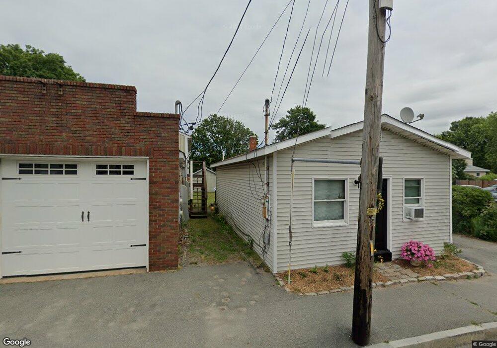
760 State Rd Westport, MA 02790
North Westport NeighborhoodEstimated Value: $250,194 - $337,000
2
Beds
1
Bath
744
Sq Ft
$375/Sq Ft
Est. Value
About This Home
This home is located at 760 State Rd, Westport, MA 02790 and is currently estimated at $279,299, approximately $375 per square foot. 760 State Rd is a home located in Bristol County with nearby schools including Alice A. Macomber Primary School, Westport Elementary School, and Westport Middle-High School.
Ownership History
Date
Name
Owned For
Owner Type
Purchase Details
Closed on
Mar 3, 2005
Sold by
Jtk Rt and Barreira Timothy L
Bought by
Ainsworth-Wright Paula J
Current Estimated Value
Purchase Details
Closed on
Nov 8, 1999
Sold by
Soares Joyce and Leboeuf Pauline
Bought by
Barreira James S
Create a Home Valuation Report for This Property
The Home Valuation Report is an in-depth analysis detailing your home's value as well as a comparison with similar homes in the area
Home Values in the Area
Average Home Value in this Area
Purchase History
| Date | Buyer | Sale Price | Title Company |
|---|---|---|---|
| Ainsworth-Wright Paula J | $125,000 | -- | |
| Ainsworth-Wright Paula J | $125,000 | -- | |
| Barreira James S | $35,000 | -- | |
| Barreira James S | $35,000 | -- |
Source: Public Records
Tax History
| Year | Tax Paid | Tax Assessment Tax Assessment Total Assessment is a certain percentage of the fair market value that is determined by local assessors to be the total taxable value of land and additions on the property. | Land | Improvement |
|---|---|---|---|---|
| 2025 | $1,424 | $191,200 | $111,600 | $79,600 |
| 2024 | $1,406 | $181,900 | $103,400 | $78,500 |
| 2023 | $1,303 | $159,700 | $88,100 | $71,600 |
| 2022 | $1,215 | $149,000 | $88,100 | $60,900 |
| 2021 | $3,612 | $141,000 | $80,100 | $60,900 |
| 2020 | $1,162 | $137,800 | $76,900 | $60,900 |
| 2019 | $3,497 | $153,000 | $93,300 | $59,700 |
| 2018 | $1,309 | $160,200 | $102,700 | $57,500 |
| 2017 | $3,176 | $159,100 | $102,700 | $56,400 |
| 2016 | $1,235 | $156,100 | $102,700 | $53,400 |
| 2015 | $1,192 | $150,300 | $102,700 | $47,600 |
Source: Public Records
Map
Nearby Homes
- 16 Lenox Ave
- 13 3rd Ave
- 116 Gifford Rd
- 15 S Breault St
- 2 Van Buren St
- 565 Highland Ave
- 0 Hertitage Acres
- 100 D Dr
- 2 Fieldstone Dr
- 3 Diane Way
- 1276 Old Fall River Rd
- 2 Winterberry Ln
- 0 American Legion Hwy Unit 73473517
- 19 Charles Joseph Dr
- 588 Gifford Rd
- 2 Donna Marie Dr
- 300 Davis Rd
- 0 Bergeron Ln Unit 73483440
- 21 Evergreen St
- 358 Briggs Rd
- 762 State Rd
- 756 State Rd Unit 758
- 4 Acushnet Ave
- 13 Pine Tree Ave
- 768 State Rd
- 748 State Rd
- 12 Acushnet Ave
- 0 State Rd (Route 6) Unit 70633240
- 0 State Rd (Route 6) Unit 70780137
- 5 Acushnet Ave
- 6 Pine Tree Ave
- 761 State Rd
- 755 State Rd
- 755 State Rd Unit A
- 757 State Rd
- 12 Pine Tree Ave
- 16 Acushnet Ave
- 744 State Rd
- 774 State Rd
- 11 Acushnet Ave
Your Personal Tour Guide
Ask me questions while you tour the home.