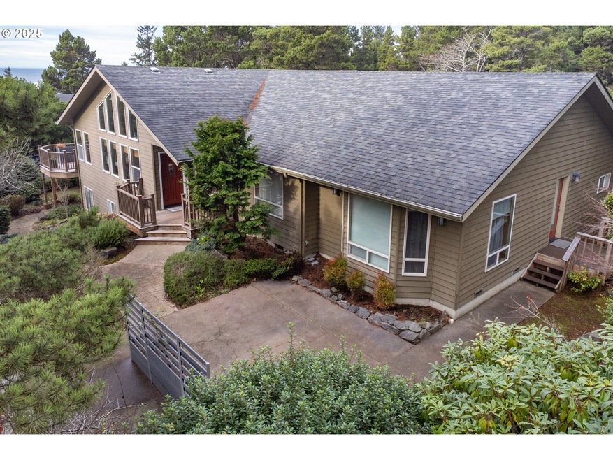
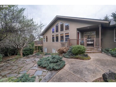
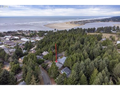
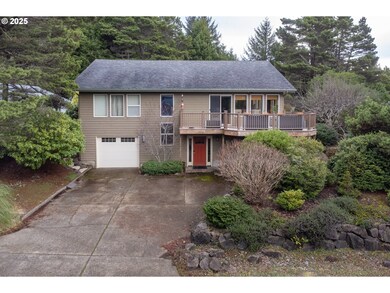
760 SW Range Dr Waldport, OR 97394
Estimated payment $4,849/month
Highlights
- Spa
- View of Trees or Woods
- Vaulted Ceiling
- RV Access or Parking
- Deck
- Traditional Architecture
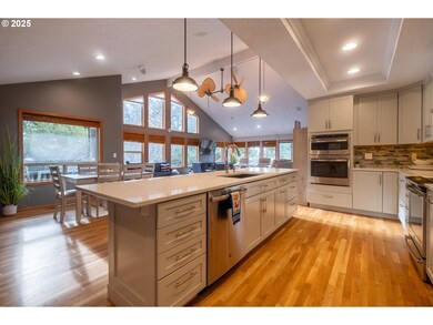
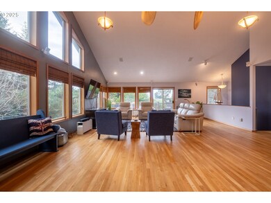
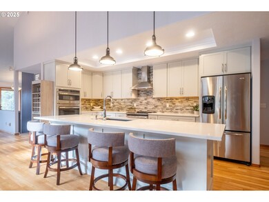
About This Home
This Luxury Retreat with 3 Bedrooms and 3.5 Bathrooms is perfect for your forever Home or Vacation getaway and ideal for entertaining Family and Friends whether it be a BBQ , Holiday Celebration or an amazing place to relax. Enjoy the private indoor Jacuzzi and then stroll into the Main Living / Dining area for a savory meal while viewing your favorite movie or beautiful music.The Downstairs is a one Bedroom / one Bath Apartment suite with a private entrance for your long term guest or additional rental Income. This Property is close to Downtown Waldport for Shopping, Restaurants and Sandy Beaches. A quick drive to Yachats and Newport if you are craving a Movie Day and a wider variety of places to explore. Call for an appointment and allow us to make your dream a reality.
Listing Agent
Taylor & Taylor Realty Co. Brokerage Phone: 541-994-9111 License #201235569 Listed on: 11/07/2025
Home Details
Home Type
- Single Family
Est. Annual Taxes
- $7,899
Year Built
- Built in 1993
Lot Details
- 8,712 Sq Ft Lot
- Corner Lot
- Property is zoned R-1-A
Parking
- 1 Car Attached Garage
- Oversized Parking
- Driveway
- RV Access or Parking
- Controlled Entrance
Home Design
- Traditional Architecture
- Composition Roof
- Lap Siding
- Concrete Perimeter Foundation
Interior Spaces
- 3,339 Sq Ft Home
- 2-Story Property
- Vaulted Ceiling
- Double Pane Windows
- Family Room
- Living Room
- Dining Room
- Wood Flooring
- Views of Woods
- Finished Basement
- Apartment Living Space in Basement
- Washer and Dryer
Kitchen
- Free-Standing Gas Range
- Range Hood
- Microwave
- Dishwasher
- Stainless Steel Appliances
- Kitchen Island
- Quartz Countertops
- Disposal
Bedrooms and Bathrooms
- 3 Bedrooms
- Soaking Tub
Outdoor Features
- Spa
- Deck
Additional Homes
- Accessory Dwelling Unit (ADU)
Schools
- Crestview Hghts Elementary School
- Waldport Middle School
- Waldport High School
Utilities
- Cooling Available
- Heating System Uses Gas
- Heat Pump System
- Electric Water Heater
- High Speed Internet
Community Details
- No Home Owners Association
Listing and Financial Details
- Assessor Parcel Number R105735
Map
Home Values in the Area
Average Home Value in this Area
Tax History
| Year | Tax Paid | Tax Assessment Tax Assessment Total Assessment is a certain percentage of the fair market value that is determined by local assessors to be the total taxable value of land and additions on the property. | Land | Improvement |
|---|---|---|---|---|
| 2024 | $7,478 | $448,840 | -- | -- |
| 2023 | $7,259 | $435,770 | $0 | $0 |
| 2022 | $7,011 | $423,080 | $0 | $0 |
| 2021 | $6,834 | $410,760 | $0 | $0 |
| 2020 | $6,700 | $398,800 | $0 | $0 |
| 2019 | $6,446 | $387,190 | $0 | $0 |
| 2018 | $6,319 | $375,920 | $0 | $0 |
| 2017 | $5,956 | $360,590 | $0 | $0 |
| 2016 | $5,538 | $333,820 | $0 | $0 |
| 2015 | $4,391 | $304,400 | $0 | $0 |
| 2014 | $4,416 | $305,880 | $0 | $0 |
| 2013 | -- | $287,690 | $0 | $0 |
Property History
| Date | Event | Price | List to Sale | Price per Sq Ft |
|---|---|---|---|---|
| 11/07/2025 11/07/25 | For Sale | $799,000 | -- | $239 / Sq Ft |
Purchase History
| Date | Type | Sale Price | Title Company |
|---|---|---|---|
| Warranty Deed | $835,000 | Western Title |
Mortgage History
| Date | Status | Loan Amount | Loan Type |
|---|---|---|---|
| Open | $647,200 | New Conventional |
Source: Regional Multiple Listing Service (RMLS)
MLS Number: 492292183
APN: R105735
Disclaimer: Certain information contained herein is derived from information provided by parties other than Homes.com. All information provided is deemed reliable, but is not guaranteed to be accurate and should be independently verified.
![]() The content relating to real estate for sale on this web site comes in part from the IDX program of the RMLS™ of Portland, Oregon. Real estate listings held by brokerage firms other than Ten-X are marked with the RMLS™ logo, and detailed information about these properties includes the names of the listing brokers. Listing content is copyright © 2025 RMLS™, Portland, Oregon. Some properties which appear for sale on this web site may subsequently have sold or may no longer be available. All information provided is deemed reliable but is not guaranteed and should be independently verified.
The content relating to real estate for sale on this web site comes in part from the IDX program of the RMLS™ of Portland, Oregon. Real estate listings held by brokerage firms other than Ten-X are marked with the RMLS™ logo, and detailed information about these properties includes the names of the listing brokers. Listing content is copyright © 2025 RMLS™, Portland, Oregon. Some properties which appear for sale on this web site may subsequently have sold or may no longer be available. All information provided is deemed reliable but is not guaranteed and should be independently verified.
- TL 10200 SW Chad Dr
- 1420 SW Fairway Dr
- 1590 SW Fairway Dr
- 1345 SW Fairway Dr
- 700 Blk SW Kelsie Ln
- 1410 SW Forest Pkwy
- 1200 Blk Sw Norwood Drive Tl0120
- 1200 Blk Norwood Dr Tl012
- 415 SW Range Dr
- 600 SW Pacific Coast Hwy
- 1085 SW Norwood Dr
- 925 SW Dolores Dr
- 1409 SW Adahi Ave
- TL 300 SW Dolores Dr
- 125 SW Range Dr Unit 2
- TL 600 SW Sailfish Loop
- TL-700 SW Sailfish
- 2220 SW Green Ln
- 1215 SW Ocean Hills Dr
- 1445 S Crestline Dr
