Estimated Value: $545,326
Studio
--
Bath
1,684
Sq Ft
$324/Sq Ft
Est. Value
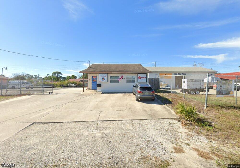
About This Home
This home is located at 760 West Ave, Cocoa, FL 32927 and is currently priced at $545,326, approximately $323 per square foot. 760 West Ave is a home located in Brevard County with nearby schools including Atlantis Elementary School, Space Coast Junior/Senior High School, and East Atlantic Prep of Brevard County.
Ownership History
Date
Name
Owned For
Owner Type
Purchase Details
Closed on
Jun 20, 2024
Sold by
Stevens David R and Stevens Vicki C
Bought by
Djm Enterprises Inc
Current Estimated Value
Purchase Details
Closed on
Aug 4, 2021
Sold by
Stevens David
Bought by
Stevens David R and Stevens Vicki C
Purchase Details
Closed on
Feb 11, 2015
Sold by
Krzyston Michael J and Krzyston Patricia L
Bought by
Stevens David
Purchase Details
Closed on
Oct 25, 2005
Sold by
Krzyston Michael J
Bought by
Krzyston Michael J and Krzyston Patricia L
Purchase Details
Closed on
Oct 6, 2005
Sold by
Krzyston Stanley and Stanley Krzyston Trust
Bought by
Krzyston Michael J
Purchase Details
Closed on
Jan 6, 1997
Sold by
Krzyston Stanley
Bought by
Krzyston Stanley
Create a Home Valuation Report for This Property
The Home Valuation Report is an in-depth analysis detailing your home's value as well as a comparison with similar homes in the area
Home Values in the Area
Average Home Value in this Area
Purchase History
| Date | Buyer | Sale Price | Title Company |
|---|---|---|---|
| Djm Enterprises Inc | $500,000 | None Listed On Document | |
| Djm Enterprises Inc | $500,000 | None Listed On Document | |
| Stevens David R | $57,800 | Accommodation | |
| Stevens David | $183,000 | Liberty Title Company | |
| Krzyston Michael J | -- | -- | |
| Krzyston Michael J | -- | -- | |
| Krzyston Stanley | -- | -- |
Source: Public Records
Tax History Compared to Growth
Tax History
| Year | Tax Paid | Tax Assessment Tax Assessment Total Assessment is a certain percentage of the fair market value that is determined by local assessors to be the total taxable value of land and additions on the property. | Land | Improvement |
|---|---|---|---|---|
| 2025 | $3,102 | $199,930 | -- | -- |
| 2024 | $3,170 | $184,800 | -- | -- |
| 2023 | $3,170 | $184,800 | -- | -- |
| 2022 | $2,875 | $168,000 | $0 | $0 |
| 2021 | $2,968 | $168,000 | $52,880 | $115,120 |
| 2020 | $3,006 | $168,000 | $52,880 | $115,120 |
| 2019 | $3,007 | $168,000 | $52,880 | $115,120 |
| 2018 | $3,075 | $168,000 | $52,880 | $115,120 |
| 2017 | $3,135 | $160,000 | $0 | $160,000 |
| 2016 | $3,251 | $158,000 | $0 | $0 |
| 2015 | $1,657 | $60,000 | $37,690 | $22,310 |
| 2014 | $1,675 | $60,000 | $37,690 | $22,310 |
Source: Public Records
Map
Nearby Homes
- 1164 Aron St
- 672 Altura Dr
- 6900 N Highway 1 Unit 6307
- 1108 Vineland St
- 6760 N Highway 1 Unit 3204
- 641 Lindsay Ave
- 6800 N Highway 1 Unit 4202
- 721 Alcazar Ave
- 780 Alcazar Ave
- 1018 Albin St
- 7000 N Highway 1 Unit 104
- 7000 N Highway 1 Unit Gg-205
- 461 Camel Cir
- 7020 U S 1 Unit Ee-202
- 0 Fay Blvd Unit 1011912
- 453 Camel Cir
- 933 Fay Blvd
- 5660 N Highway 1
- 7030 N Highway 1 Unit 101
- 7030 N Highway 1 Unit DD102
- 1271 Aron St
- 724 West Ave Unit 724
- 1271 Vineland St
- 1261 Vineland St
- 1261 Aron St
- * Route 1
- 4650 Route 1
- 1251 Vineland St
- 0 Route 1 Unit 1038350
- 0 Route 1 Unit 1037489
- 0 Route 1 Unit MFRO6182271
- 0 Route 1 Unit MFRO6182262
- 0 Route 1 Unit 105 MFRO4713097
- 0 Route 1
- 6320 U S Highway 1
- 00 U S Highway 1
- 5285 U S Route 1
- 700 West Ave Unit 716
- 700 West Ave Unit 716-71
- 700 West Ave Unit 726