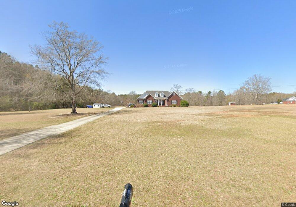
760 Will Hanks Rd Honea Path, SC 29654
Estimated Value: $240,000 - $544,169
3
Beds
--
Bath
2,496
Sq Ft
$169/Sq Ft
Est. Value
About This Home
This home is located at 760 Will Hanks Rd, Honea Path, SC 29654 and is currently estimated at $422,292, approximately $169 per square foot. 760 Will Hanks Rd is a home with nearby schools including Belton Honea Path High School and Whispering Pines Mennonite School.
Ownership History
Date
Name
Owned For
Owner Type
Purchase Details
Closed on
Feb 8, 2005
Sold by
Branyon Steven G and Branyon Donnie
Bought by
Williams Steven Heath and Williams Jaime S
Current Estimated Value
Create a Home Valuation Report for This Property
The Home Valuation Report is an in-depth analysis detailing your home's value as well as a comparison with similar homes in the area
Home Values in the Area
Average Home Value in this Area
Purchase History
| Date | Buyer | Sale Price | Title Company |
|---|---|---|---|
| Williams Steven Heath | $25,000 | -- |
Source: Public Records
Tax History
| Year | Tax Paid | Tax Assessment Tax Assessment Total Assessment is a certain percentage of the fair market value that is determined by local assessors to be the total taxable value of land and additions on the property. | Land | Improvement |
|---|---|---|---|---|
| 2024 | $2,052 | $16,730 | $1,720 | $15,010 |
| 2023 | $2,033 | $16,730 | $1,720 | $15,010 |
| 2022 | $2,011 | $16,730 | $1,720 | $15,010 |
| 2021 | $1,812 | $13,910 | $1,650 | $12,260 |
| 2020 | $1,797 | $13,910 | $1,650 | $12,260 |
| 2019 | $1,797 | $13,910 | $1,650 | $12,260 |
| 2018 | $1,838 | $13,910 | $1,650 | $12,260 |
| 2017 | -- | $13,910 | $1,650 | $12,260 |
| 2016 | $1,754 | $12,880 | $880 | $12,000 |
| 2015 | $1,895 | $12,880 | $880 | $12,000 |
| 2014 | $1,914 | $12,880 | $880 | $12,000 |
Source: Public Records
Map
Nearby Homes
- 704 Sherwood Ave
- 520 Elizabeth Street Extension
- 310 Oak Dr
- 305 Tribble St
- 307 Tribble St
- 00 Brook St
- 701 W Greer St
- 302 W Hampton Ave
- 00 Ervin St
- 227 S Main St
- 7 Carlisle Dr
- 229 Armstrong Rd
- 417 N Main St
- 5 George St
- 20 Sanders St
- Clatworthy Rd
- 600 N Main St
- 511 N Main St
- Clatworthy Rd
- 00 Clatworthy Rd
- 750 Will Hanks Rd
- 1000 Will Hanks Rd
- 785 Will Hanks Rd
- 1027 Will Hanks Rd
- 1320 Paige Rd
- 1040 Will Hanks Rd
- 1116 Paige Rd
- 1110 Paige Rd
- 618 Will Hanks Rd
- 1340 Paige Rd
- 1055 Will Hanks Rd
- 614 Will Hanks Rd
- 1015 Paige Rd
- 1311 Paige Rd
- 1366 Paige Rd
- 602 Will Hanks Rd
- 1011 Paige Rd
- 1135 Paige Rd
- 604 Will Hanks Rd
- 1613 Sauer Farm Rd
Your Personal Tour Guide
Ask me questions while you tour the home.