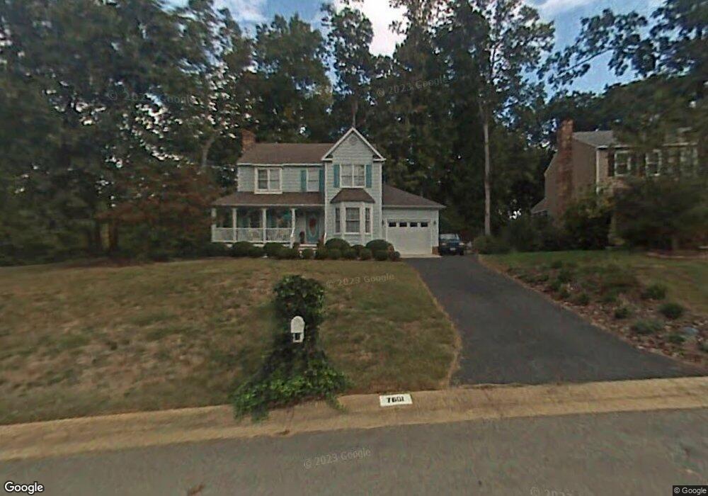
7601 Ratling Dr Midlothian, VA 23112
Estimated Value: $363,000 - $391,304
3
Beds
3
Baths
1,646
Sq Ft
$228/Sq Ft
Est. Value
About This Home
This home is located at 7601 Ratling Dr, Midlothian, VA 23112 and is currently estimated at $375,326, approximately $228 per square foot. 7601 Ratling Dr is a home located in Chesterfield County with nearby schools including Spring Run Elementary School, Bailey Bridge Middle School, and Manchester High.
Ownership History
Date
Name
Owned For
Owner Type
Purchase Details
Closed on
Mar 23, 2020
Sold by
Mcneil Jean B
Bought by
Mcneil Jean B and The Jean B Mcneil Trust
Current Estimated Value
Purchase Details
Closed on
Mar 6, 2002
Bought by
Mcneil Jean B
Home Financials for this Owner
Home Financials are based on the most recent Mortgage that was taken out on this home.
Original Mortgage
$100,000
Outstanding Balance
$41,626
Interest Rate
7.01%
Mortgage Type
New Conventional
Estimated Equity
$333,700
Create a Home Valuation Report for This Property
The Home Valuation Report is an in-depth analysis detailing your home's value as well as a comparison with similar homes in the area
Home Values in the Area
Average Home Value in this Area
Purchase History
| Date | Buyer | Sale Price | Title Company |
|---|---|---|---|
| Mcneil Jean B | -- | None Available | |
| Mcneil Jean B | -- | -- |
Source: Public Records
Mortgage History
| Date | Status | Borrower | Loan Amount |
|---|---|---|---|
| Open | Mcneil Jean B | $100,000 |
Source: Public Records
Tax History
| Year | Tax Paid | Tax Assessment Tax Assessment Total Assessment is a certain percentage of the fair market value that is determined by local assessors to be the total taxable value of land and additions on the property. | Land | Improvement |
|---|---|---|---|---|
| 2025 | $3,064 | $341,500 | $62,000 | $279,500 |
| 2024 | $3,064 | $330,300 | $60,000 | $270,300 |
| 2023 | $2,832 | $311,200 | $57,000 | $254,200 |
| 2022 | $2,628 | $285,700 | $54,000 | $231,700 |
| 2021 | $2,372 | $247,000 | $52,000 | $195,000 |
| 2020 | $2,225 | $234,200 | $50,000 | $184,200 |
| 2019 | $2,098 | $220,800 | $48,000 | $172,800 |
| 2018 | $2,056 | $216,400 | $47,000 | $169,400 |
| 2017 | $1,962 | $204,400 | $44,000 | $160,400 |
| 2016 | $1,881 | $195,900 | $43,000 | $152,900 |
| 2015 | $1,814 | $186,400 | $42,000 | $144,400 |
| 2014 | $1,740 | $178,600 | $41,000 | $137,600 |
Source: Public Records
Map
Nearby Homes
- 14000 Key Deer Dr
- 13925 Buck Rub Dr
- 13836 Buck Rub Dr
- 13903 Deer Thicket Ln
- 7706 Northern Dancer Ct
- 14001 Palomino Way
- 13624 Lucky Debonair Ln
- 14412 Ashdale Way
- 13924 Spyglass Hill Cir
- 8313 Houghton Place
- 13830 Spyglass Hill Cir
- 14431 Hancock Towns Dr
- 8801 Thornton Heath Dr
- 14479 Hancock Towns Dr
- 14481 Hancock Towns Dr Unit F 2-2
- 8843 Pebble Beach Ct
- 6903 Whistlers Cove Dr
- 7417 Hancock Towns Ct
- 14637 Hancock Towns Dr Unit P-1
- 14639 Hancock Towns Dr
- 7607 Ratling Dr
- 7600 Flag Tail Dr
- 7606 Flag Tail Dr
- 14201 Spotted Coat Ct
- 7613 Ratling Dr
- 7518 Flag Tail Dr
- 14203 Spotted Coat Ct
- 14202 Flag Tail Way
- 7600 Ratling Dr
- 7612 Ratling Dr
- 14200 Flag Tail Way
- 14204 Flag Tail Way
- 7619 Ratling Dr
- 14205 Spotted Coat Ct
- 7516 Flag Tail Dr
- 14200 Spotted Coat Ct
- 7618 Ratling Dr
- 14207 Spotted Coat Ct
- 7625 Ratling Dr
- 14206 Flag Tail Way
Your Personal Tour Guide
Ask me questions while you tour the home.