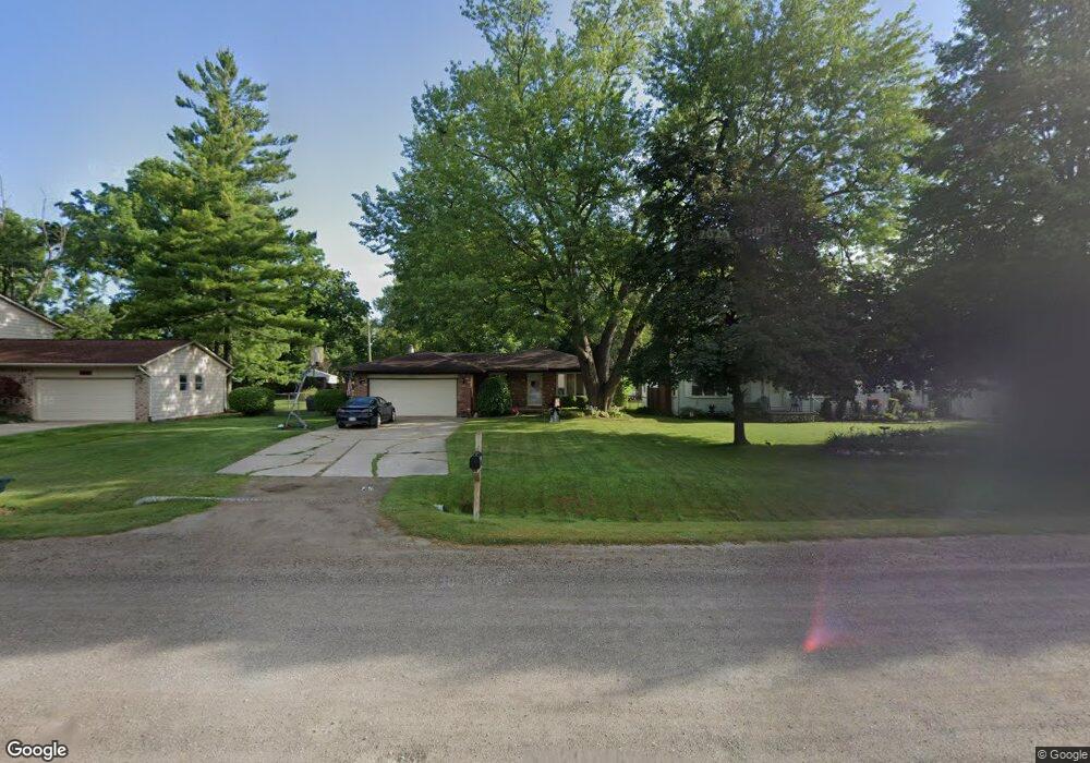
7601 Smale St Washington, MI 48094
Estimated Value: $283,116 - $320,000
--
Bed
2
Baths
1,416
Sq Ft
$215/Sq Ft
Est. Value
About This Home
This home is located at 7601 Smale St, Washington, MI 48094 and is currently estimated at $304,779, approximately $215 per square foot. 7601 Smale St is a home located in Macomb County with nearby schools including Cross Of Glory Lutheran School and Peace Lutheran School.
Ownership History
Date
Name
Owned For
Owner Type
Purchase Details
Closed on
Oct 12, 2004
Sold by
Garrigan Patrick T and Garrigan Elba I
Bought by
Stjohn Patrick A and Stjohn Karen A
Current Estimated Value
Home Financials for this Owner
Home Financials are based on the most recent Mortgage that was taken out on this home.
Original Mortgage
$159,600
Outstanding Balance
$79,254
Interest Rate
5.81%
Mortgage Type
Purchase Money Mortgage
Estimated Equity
$225,525
Create a Home Valuation Report for This Property
The Home Valuation Report is an in-depth analysis detailing your home's value as well as a comparison with similar homes in the area
Home Values in the Area
Average Home Value in this Area
Purchase History
| Date | Buyer | Sale Price | Title Company |
|---|---|---|---|
| Stjohn Patrick A | $199,500 | -- |
Source: Public Records
Mortgage History
| Date | Status | Borrower | Loan Amount |
|---|---|---|---|
| Open | Stjohn Patrick A | $159,600 |
Source: Public Records
Tax History Compared to Growth
Tax History
| Year | Tax Paid | Tax Assessment Tax Assessment Total Assessment is a certain percentage of the fair market value that is determined by local assessors to be the total taxable value of land and additions on the property. | Land | Improvement |
|---|---|---|---|---|
| 2025 | $2,344 | $128,300 | $0 | $0 |
| 2024 | $1,584 | $121,300 | $0 | $0 |
| 2023 | $1,526 | $115,700 | $0 | $0 |
| 2022 | $2,121 | $105,700 | $0 | $0 |
| 2021 | $2,075 | $102,200 | $0 | $0 |
| 2020 | $1,413 | $95,900 | $0 | $0 |
| 2019 | $1,904 | $83,200 | $0 | $0 |
| 2018 | $1,866 | $77,200 | $0 | $0 |
| 2017 | $1,799 | $74,300 | $26,600 | $47,700 |
| 2016 | $1,802 | $74,300 | $0 | $0 |
| 2015 | -- | $60,100 | $0 | $0 |
| 2013 | $1,878 | $60,400 | $21,000 | $39,400 |
| 2012 | $1,878 | $62,600 | $0 | $0 |
Source: Public Records
Map
Nearby Homes
- 7427 Emerson
- 58019 Van Dyke Rd
- 58152 Carbine
- 6933 Boulder Pointe Dr Unit 59
- 8400 27 Mile Rd Unit Lot 2
- 8400 27 Mile Rd Unit Lot 1
- 0 Cathey Unit Lot 4
- 0 Cathey Unit Lot 5
- 6797 Boulder Pointe Dr Unit 25
- 7250 Lindrath
- 6725 Boulder Pointe Dr Unit 7
- 58144 Pheasant Ridge
- 7070 Venturi Dr
- 59601 Van Dyke Rd
- 57136 Megan Dr
- 8699 Pioneer St
- 57911 Lancaster Rd
- 57016 Megan Dr
- 59055 Golden Oak Ct
- 00 Oakridge Dr