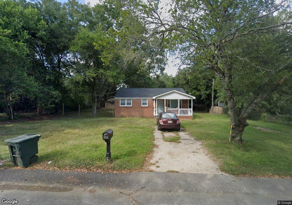
7603 Marie St Columbia, SC 29209
Southeast Columbia NeighborhoodEstimated Value: $139,000 - $150,000
3
Beds
1
Bath
945
Sq Ft
$153/Sq Ft
Est. Value
About This Home
This home is located at 7603 Marie St, Columbia, SC 29209 and is currently estimated at $144,431, approximately $152 per square foot. 7603 Marie St is a home located in Richland County with nearby schools including Mill Creek Elementary School, Hopkins Middle School, and Lower Richland High School.
Ownership History
Date
Name
Owned For
Owner Type
Purchase Details
Closed on
Apr 24, 2025
Sold by
R T S Development Llc
Bought by
R T S 2 Development Llc
Current Estimated Value
Home Financials for this Owner
Home Financials are based on the most recent Mortgage that was taken out on this home.
Original Mortgage
$1,902,500
Outstanding Balance
$1,894,055
Interest Rate
6.65%
Mortgage Type
New Conventional
Estimated Equity
-$1,749,624
Purchase Details
Closed on
Nov 30, 2018
Sold by
Wyatt Ray L
Bought by
R T S Development Llc
Purchase Details
Closed on
Nov 17, 2018
Sold by
Ward Kenneth D
Bought by
Wyatt Ray L
Purchase Details
Closed on
May 19, 2006
Sold by
Ward Kenneth D and Estate Of Mary Frances Wyatt
Bought by
Ward Kenneth D and Wyatt Ray L
Create a Home Valuation Report for This Property
The Home Valuation Report is an in-depth analysis detailing your home's value as well as a comparison with similar homes in the area
Home Values in the Area
Average Home Value in this Area
Purchase History
| Date | Buyer | Sale Price | Title Company |
|---|---|---|---|
| R T S 2 Development Llc | -- | None Listed On Document | |
| R T S Development Llc | $10,500 | None Available | |
| Wyatt Ray L | -- | None Available | |
| Ward Kenneth D | -- | None Available |
Source: Public Records
Mortgage History
| Date | Status | Borrower | Loan Amount |
|---|---|---|---|
| Open | R T S 2 Development Llc | $1,902,500 |
Source: Public Records
Tax History Compared to Growth
Tax History
| Year | Tax Paid | Tax Assessment Tax Assessment Total Assessment is a certain percentage of the fair market value that is determined by local assessors to be the total taxable value of land and additions on the property. | Land | Improvement |
|---|---|---|---|---|
| 2023 | $2,075 | $2,316 | $0 | $0 |
| 2022 | $1,897 | $57,900 | $9,000 | $48,900 |
| 2021 | $1,881 | $3,470 | $0 | $0 |
| 2020 | $1,890 | $3,470 | $0 | $0 |
| 2019 | $1,861 | $3,470 | $0 | $0 |
| 2018 | $542 | $1,630 | $0 | $0 |
| 2017 | $534 | $1,630 | $0 | $0 |
| 2016 | $532 | $1,630 | $0 | $0 |
| 2015 | $522 | $1,630 | $0 | $0 |
| 2014 | $512 | $40,800 | $0 | $0 |
| 2013 | -- | $1,630 | $0 | $0 |
Source: Public Records
Map
Nearby Homes
- 168 Ashewood Commons Dr
- 909 Eastmont Dr
- 360 Council Loop
- 842 Eastmont Dr
- 1527 Burnside Ave
- 349 Eastfair Dr
- 8025 Skylark Dr
- 797 Phipps Ln
- 113 Colonial Commons Ln
- 115 Colonial Commons Ln
- 101 Colonial Commons Ln
- 267 Blue Savannah St
- 263 Blue Savannah St
- 106 Colonial Commons Ln
- 220 Wheat Farm Rd
- 208 Wheat Farm Rd
- 217 Wheat Farm Rd
- 213 Wheat Farm Rd
- 155 Colonial Commons Ln
- 2 Routhland Ct