Estimated payment $6,400/month
Highlights
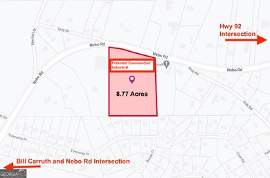
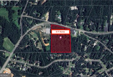
- 8.77 Acre Lot
- No HOA
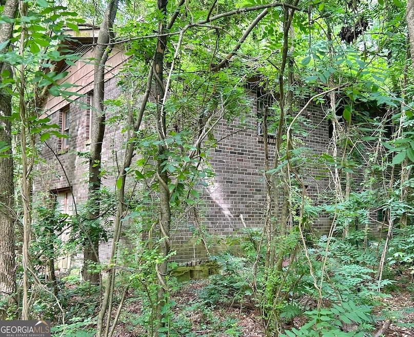
- Four Sided Brick Exterior Elevation
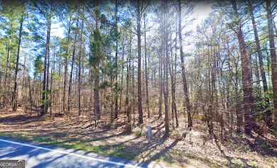
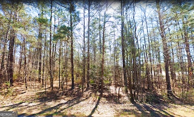
- Wooded Lot
- 1-Story Property
- Level Lot
About This Home
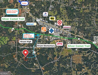
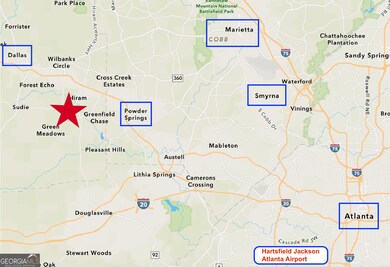
8.77 acres of Potential Commercial or Industrial. Currently Zoned Residential. Flat lot with substantial road frontage adjacent to and between Commercial C-4/B2 and E2 zoning. Approximately 1,500 feet from both Hwy 92 and Bill Carruth Pkwy. DOT widening of Hwy 92 under construction. 1+ mile to Silver Comet Trail. 2 miles to Hwy 278 Shopping and Dining, Wellstar Paulding Medical Center and Film Studios. No Trespassing.
Home Details
Home Type
- Single Family
Est. Annual Taxes
- $1,058
Year Built
- Built in 1971
Lot Details
- 8.77 Acre Lot
- Level Lot
- Wooded Lot
Home Design
- Slab Foundation
- Four Sided Brick Exterior Elevation
Interior Spaces
- 1,352 Sq Ft Home
- 1-Story Property
- Unfinished Basement
Bedrooms and Bathrooms
- 3 Main Level Bedrooms
- 1 Full Bathroom
Schools
- Sam D Panter Elementary School
- J A Dobbins Middle School
- Hiram High School
Utilities
- Septic Tank
Community Details
- No Home Owners Association
- Nebo Rd Hiram Subdivision
Listing and Financial Details
- Tax Lot 835
Map
Home Values in the Area
Average Home Value in this Area
Tax History
| Year | Tax Paid | Tax Assessment Tax Assessment Total Assessment is a certain percentage of the fair market value that is determined by local assessors to be the total taxable value of land and additions on the property. | Land | Improvement |
|---|---|---|---|---|
| 2024 | $1,078 | $158,320 | $82,320 | $76,000 |
| 2023 | $1,224 | $153,120 | $80,200 | $72,920 |
| 2022 | $1,044 | $129,520 | $65,240 | $64,280 |
| 2021 | $1,000 | $101,040 | $51,840 | $49,200 |
| 2020 | $978 | $93,360 | $48,960 | $44,400 |
| 2019 | $1,190 | $108,600 | $72,000 | $36,600 |
| 2018 | $694 | $65,720 | $42,280 | $23,440 |
| 2017 | $695 | $63,560 | $42,280 | $21,280 |
| 2016 | $1,139 | $61,480 | $42,280 | $19,200 |
| 2015 | $1,129 | $59,680 | $42,280 | $17,400 |
| 2014 | $1,227 | $57,520 | $42,280 | $15,240 |
| 2013 | -- | $52,720 | $42,160 | $10,560 |
Property History
| Date | Event | Price | List to Sale | Price per Sq Ft |
|---|---|---|---|---|
| 04/26/2024 04/26/24 | For Sale | $1,200,000 | -- | $888 / Sq Ft |
Purchase History
| Date | Type | Sale Price | Title Company |
|---|---|---|---|
| Deed | -- | -- | |
| Deed | $31,500 | -- |
Source: Georgia MLS
MLS Number: 10288216
APN: 180.4.1.025.0000
Disclaimer: Certain information contained herein is derived from information provided by parties other than Homes.com. All information provided is deemed reliable, but is not guaranteed to be accurate and should be independently verified.
![]() The data relating to real estate for sale on this web site comes in part from the Broker Reciprocity Program of Georgia MLS. Real estate listings held by brokerage firms other than Redfin are marked with the Broker Reciprocity logo and detailed information about them includes the name of the listing brokers. Information deemed reliable but not guaranteed. Copyright 2025 Georgia MLS. All rights reserved.
The data relating to real estate for sale on this web site comes in part from the Broker Reciprocity Program of Georgia MLS. Real estate listings held by brokerage firms other than Redfin are marked with the Broker Reciprocity logo and detailed information about them includes the name of the listing brokers. Information deemed reliable but not guaranteed. Copyright 2025 Georgia MLS. All rights reserved.
- 258 Cove Rd
- 222 Cove Rd
- 41 Valley Dr
- 48 Lanier Ct
- 29 Baywood Crossing
- 119 Baywood Way
- 82 Paris Cir Unit A
- 202 Monarch Way
- 256 Powder Springs St Unit A
- 78 Denver Ave
- 446 Thornbrooke Dr
- 341 Rosemont Ct
- 323 Rosemont Ct
- 546 Hardy Way
- 420 Stone Ridge Cir
- 43 Surrey Ct
- 59 Greystone Ridge
- 324 Greystone Pkwy
- 268 Hardy Way
- 240 Greystone Cir
