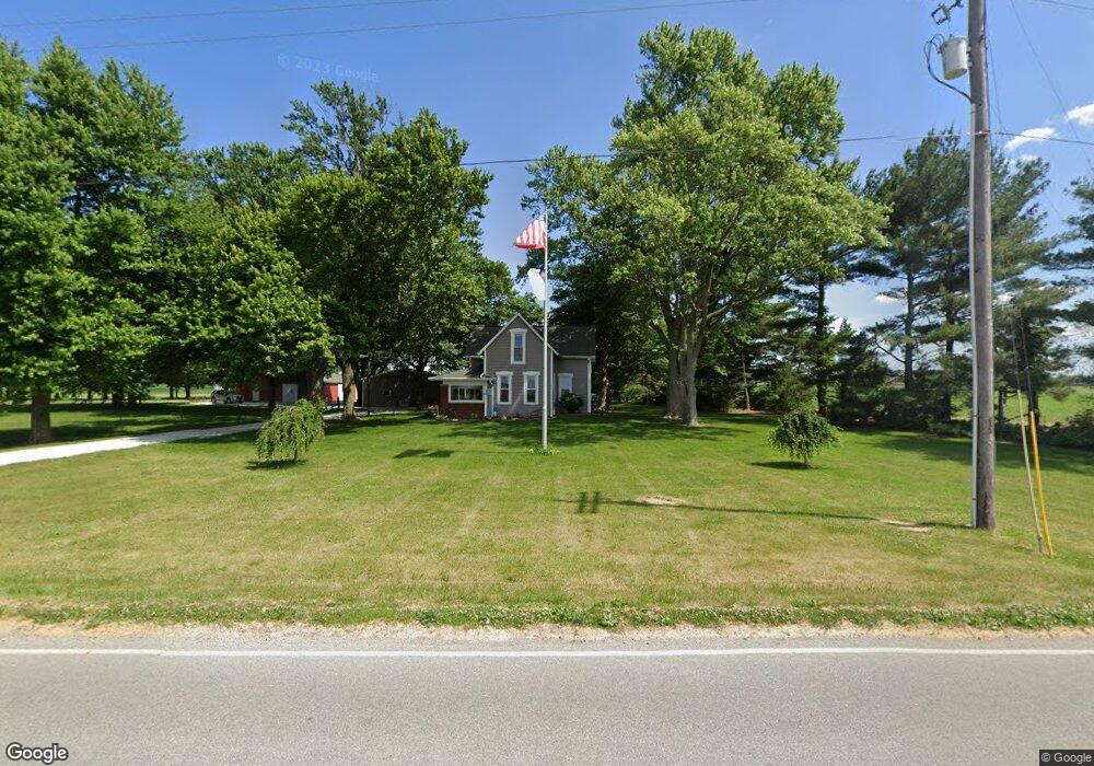
7609 W Manson Colfax Rd Colfax, IN 46035
Estimated Value: $260,000 - $446,312
3
Beds
2
Baths
2,380
Sq Ft
$139/Sq Ft
Est. Value
About This Home
This home is located at 7609 W Manson Colfax Rd, Colfax, IN 46035 and is currently estimated at $330,828, approximately $139 per square foot. 7609 W Manson Colfax Rd is a home located in Clinton County with nearby schools including Clinton Prairie Elementary School and Clinton Prairie Junior/Senior High School.
Ownership History
Date
Name
Owned For
Owner Type
Purchase Details
Closed on
Jan 12, 2016
Sold by
Timmons Michael W and Timmons Peggy J
Bought by
The Timmons Family Living Trust
Current Estimated Value
Purchase Details
Closed on
May 4, 2001
Sold by
Timmons Michael W and Timmons Jane R
Bought by
Hammel Steven E and Hammel Janet E
Purchase Details
Closed on
Apr 23, 2001
Sold by
Timmons Bill J and Dee Irma
Bought by
Timmons Michael W and Timmons Jane R
Purchase Details
Closed on
Mar 24, 2000
Sold by
Timmons Michael W and Timmons Jane R
Bought by
Timmons Michael W
Create a Home Valuation Report for This Property
The Home Valuation Report is an in-depth analysis detailing your home's value as well as a comparison with similar homes in the area
Home Values in the Area
Average Home Value in this Area
Purchase History
| Date | Buyer | Sale Price | Title Company |
|---|---|---|---|
| The Timmons Family Living Trust | -- | None Available | |
| Hammel Steven E | $80,000 | -- | |
| Timmons Michael W | -- | -- | |
| Timmons Michael W | -- | -- |
Source: Public Records
Tax History Compared to Growth
Tax History
| Year | Tax Paid | Tax Assessment Tax Assessment Total Assessment is a certain percentage of the fair market value that is determined by local assessors to be the total taxable value of land and additions on the property. | Land | Improvement |
|---|---|---|---|---|
| 2024 | $2,821 | $328,800 | $33,700 | $295,100 |
| 2023 | $3,028 | $328,400 | $33,000 | $295,400 |
| 2022 | $2,246 | $277,100 | $32,300 | $244,800 |
| 2021 | $1,868 | $222,100 | $31,900 | $190,200 |
| 2020 | $1,821 | $212,700 | $31,900 | $180,800 |
| 2019 | $1,627 | $213,200 | $32,400 | $180,800 |
| 2018 | $1,632 | $215,600 | $32,500 | $183,100 |
| 2017 | $1,521 | $216,200 | $33,100 | $183,100 |
| 2016 | $1,384 | $187,000 | $34,500 | $152,500 |
| 2014 | $1,069 | $176,600 | $34,500 | $142,100 |
Source: Public Records
Map
Nearby Homes
- 208 E Midway St
- 304 W Jefferson St
- 404 W Franklin St
- 108 N Carter St
- 5778 W County Road 300 S
- 7018 S County Road 430 W
- 7001 N 1075 W
- 2718 S County Road 450 W
- 11818 Madison St
- 9322 Main St
- 7706 N 1000 E
- 11816 Orange St
- Juniper Plan at Westfall Place
- Chestnut Plan at Westfall Place
- Walnut Plan at Westfall Place
- Ironwood Plan at Westfall Place
- Empress Plan at Westfall Place
- Ashton Plan at Westfall Place
- Spruce Plan at Westfall Place
- Palmetto Plan at Westfall Place
- 7537 W Manson Colfax Rd
- 7644 W Manson Colfax Rd
- 7644 W Mason Colfax Rd
- 7529 W Manson Colfax Rd
- 7671 W Manson Colfax Rd
- 7520 W Manson Colfax Rd
- 7461 W Manson Colfax Rd
- 5642 S Us Highway 52
- 5509 U S 52
- 5509 S Us Highway 52
- 6054 S Us Highway 52
- 7998 W Manson Colfax Rd
- 7870 W County Road 650 S
- 5851 S Broadview Rd
- 7258 W County Road 650 S
- 5983 S Broadview Rd
- 7339 W County Road 650 S
- 5787 S Broadview Rd
- 5248 S Us Highway 52