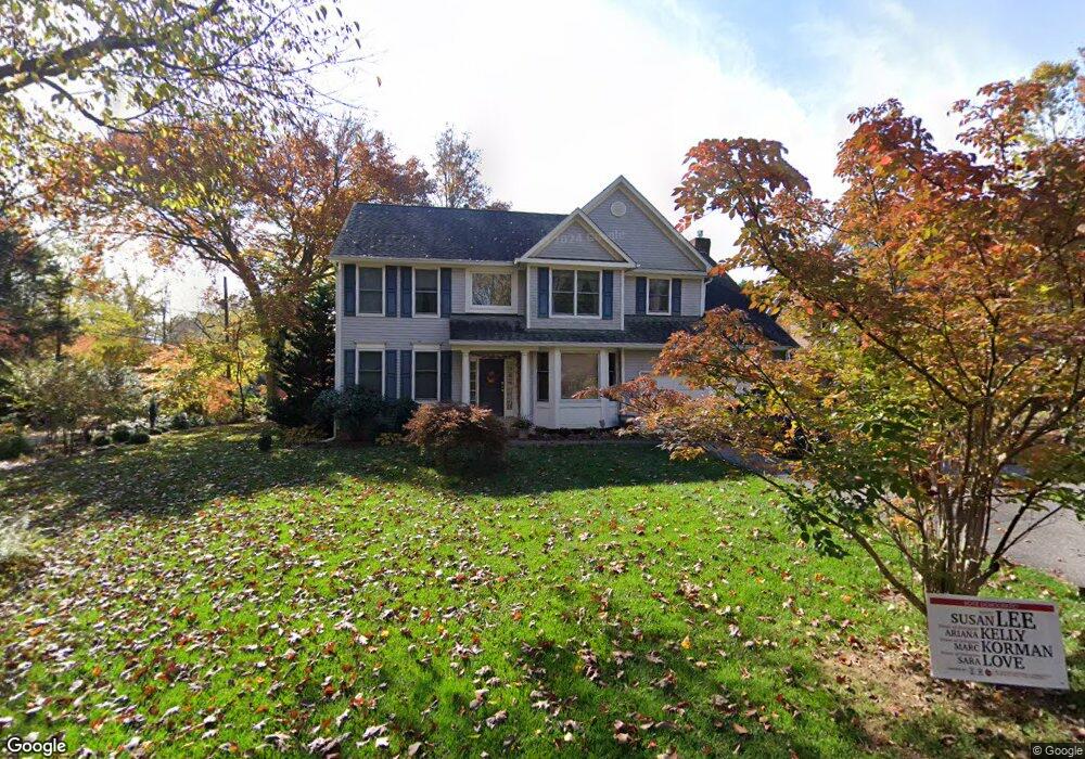
7614 Cabin Rd Cabin John, MD 20818
Estimated Value: $1,282,131 - $1,579,000
Studio
3
Baths
2,965
Sq Ft
$479/Sq Ft
Est. Value
About This Home
This home is located at 7614 Cabin Rd, Cabin John, MD 20818 and is currently estimated at $1,419,783, approximately $478 per square foot. 7614 Cabin Rd is a home located in Montgomery County with nearby schools including Bannockburn Elementary School, Thomas W. Pyle Middle School, and Walt Whitman High School.
Ownership History
Date
Name
Owned For
Owner Type
Purchase Details
Closed on
Aug 11, 2022
Sold by
Jennings James J and Jennings Delia M
Bought by
Jennings-Mckinney Family Joint Trust
Current Estimated Value
Purchase Details
Closed on
Oct 19, 1994
Sold by
Morgal David E
Bought by
Jennings James J
Home Financials for this Owner
Home Financials are based on the most recent Mortgage that was taken out on this home.
Original Mortgage
$290,000
Interest Rate
8.49%
Create a Home Valuation Report for This Property
The Home Valuation Report is an in-depth analysis detailing your home's value as well as a comparison with similar homes in the area
Home Values in the Area
Average Home Value in this Area
Purchase History
| Date | Buyer | Sale Price | Title Company |
|---|---|---|---|
| Jennings-Mckinney Family Joint Trust | -- | Friendship Title | |
| Jennings-Mckinney Family Joint Trust | -- | Friendship Title | |
| Jennings James J | $190,000 | -- |
Source: Public Records
Mortgage History
| Date | Status | Borrower | Loan Amount |
|---|---|---|---|
| Previous Owner | Jennings James J | $290,000 |
Source: Public Records
Tax History
| Year | Tax Paid | Tax Assessment Tax Assessment Total Assessment is a certain percentage of the fair market value that is determined by local assessors to be the total taxable value of land and additions on the property. | Land | Improvement |
|---|---|---|---|---|
| 2025 | $13,145 | $1,108,500 | $662,800 | $445,700 |
| 2024 | $13,145 | $1,078,367 | $0 | $0 |
| 2023 | $12,089 | $1,048,233 | $0 | $0 |
| 2022 | $11,196 | $1,018,100 | $631,200 | $386,900 |
| 2021 | $11,046 | $1,015,967 | $0 | $0 |
| 2020 | $11,046 | $1,013,833 | $0 | $0 |
| 2019 | $10,985 | $1,011,700 | $631,200 | $380,500 |
| 2018 | $10,739 | $990,500 | $0 | $0 |
| 2017 | $10,689 | $969,300 | $0 | $0 |
| 2016 | -- | $948,100 | $0 | $0 |
| 2015 | $8,055 | $890,500 | $0 | $0 |
| 2014 | $8,055 | $832,900 | $0 | $0 |
Source: Public Records
Map
Nearby Homes
- 6514 76th St
- 7630 Tomlinson Ave Unit L16
- 6908 Carmichael Ave
- 7215 Helmsdale Rd
- 7115 Crail Dr
- 6411 83rd Place
- 7502 Nevis Rd
- 7201 Selkirk Dr
- 7008 Amy Ln
- 7708 Beech Tree Rd
- 7017 Richard Dr
- 6705 Goldsboro Rd
- 8213 River Quarry Place
- 8617 Carlynn Dr
- 7318 Burdette Ct
- 7808 Winterberry Place
- 7709 Sebago Rd
- 8301 Rising Ridge Way
- 7805 Cayuga Ave
- 6570 Fallwind Ln
Your Personal Tour Guide
Ask me questions while you tour the home.