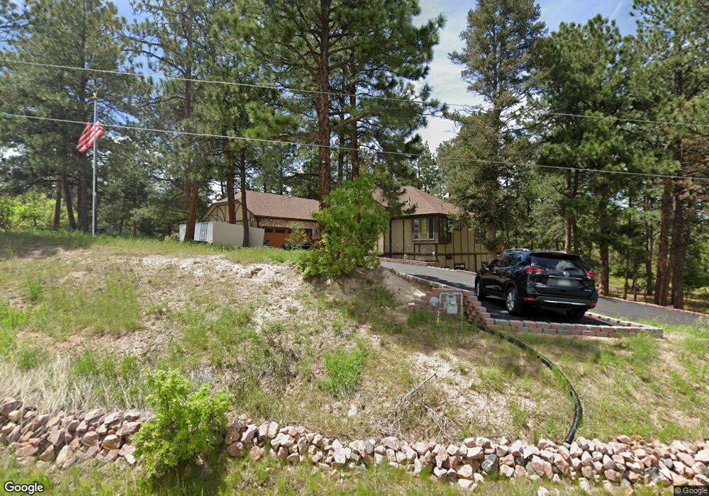
7615 Rollins Dr Larkspur, CO 80118
Estimated Value: $859,000 - $987,000
5
Beds
3
Baths
3,554
Sq Ft
$257/Sq Ft
Est. Value
About This Home
This home is located at 7615 Rollins Dr, Larkspur, CO 80118 and is currently estimated at $914,443, approximately $257 per square foot. 7615 Rollins Dr is a home located in Douglas County with nearby schools including Larkspur Elementary School, Castle Rock Middle School, and Castle View High School.
Ownership History
Date
Name
Owned For
Owner Type
Purchase Details
Closed on
Jan 10, 2025
Sold by
Thurber Stanley S and Thurber Teresa J
Bought by
Thurber Family Trust
Current Estimated Value
Purchase Details
Closed on
May 19, 2017
Sold by
Dexter Timothy Holdsworth and Dexter Tara
Bought by
Thurber Stanely S and Thurber Teresa J
Home Financials for this Owner
Home Financials are based on the most recent Mortgage that was taken out on this home.
Original Mortgage
$515,087
Interest Rate
4.08%
Mortgage Type
VA
Purchase Details
Closed on
Sep 26, 2006
Sold by
Brandt Joseph Michael
Bought by
Dexter Timothy Holdsworth and Dexter Tara
Home Financials for this Owner
Home Financials are based on the most recent Mortgage that was taken out on this home.
Original Mortgage
$395,000
Interest Rate
6.87%
Mortgage Type
Unknown
Purchase Details
Closed on
Aug 16, 2002
Sold by
Diaz Ronald and Diaz Cherrie R
Bought by
Brandt Joseph Michael
Home Financials for this Owner
Home Financials are based on the most recent Mortgage that was taken out on this home.
Original Mortgage
$263,200
Interest Rate
6.6%
Purchase Details
Closed on
Aug 5, 1996
Sold by
Collen Group Inc
Bought by
Diaz Ronald and Diaz Cherrie R
Purchase Details
Closed on
Aug 30, 1995
Sold by
Moore William W
Bought by
Collen Group Inc
Purchase Details
Closed on
Mar 9, 1978
Sold by
Unavailable
Bought by
Unavailable
Create a Home Valuation Report for This Property
The Home Valuation Report is an in-depth analysis detailing your home's value as well as a comparison with similar homes in the area
Home Values in the Area
Average Home Value in this Area
Purchase History
| Date | Buyer | Sale Price | Title Company |
|---|---|---|---|
| Thurber Family Trust | -- | None Listed On Document | |
| Thurber Stanely S | $523,000 | None Available | |
| Dexter Timothy Holdsworth | $395,000 | Land Title | |
| Brandt Joseph Michael | $329,000 | Land Title | |
| Diaz Ronald | $41,000 | -- | |
| Collen Group Inc | $5,000 | -- | |
| Unavailable | $8,500 | -- |
Source: Public Records
Mortgage History
| Date | Status | Borrower | Loan Amount |
|---|---|---|---|
| Previous Owner | Thurber Stanely S | $515,087 | |
| Previous Owner | Dexter Timothy Holdsworth | $395,000 | |
| Previous Owner | Brandt Joseph Michael | $263,200 |
Source: Public Records
Tax History Compared to Growth
Tax History
| Year | Tax Paid | Tax Assessment Tax Assessment Total Assessment is a certain percentage of the fair market value that is determined by local assessors to be the total taxable value of land and additions on the property. | Land | Improvement |
|---|---|---|---|---|
| 2024 | $5,584 | $60,970 | $12,560 | $48,410 |
| 2023 | $5,640 | $60,970 | $12,560 | $48,410 |
| 2022 | $4,003 | $42,260 | $8,590 | $33,670 |
| 2021 | $4,143 | $42,260 | $8,590 | $33,670 |
| 2020 | $3,777 | $39,320 | $7,430 | $31,890 |
| 2019 | $3,790 | $39,320 | $7,430 | $31,890 |
| 2018 | $3,091 | $31,510 | $6,800 | $24,710 |
| 2017 | $2,905 | $31,510 | $6,800 | $24,710 |
| 2016 | $2,983 | $31,820 | $6,530 | $25,290 |
| 2015 | $2,917 | $31,820 | $6,530 | $25,290 |
| 2014 | $2,458 | $25,140 | $4,700 | $20,440 |
Source: Public Records
Map
Nearby Homes
- 7596 Rollins Dr
- 1600 Independence Dr Unit 50
- 1065 Independence Dr
- 1038 Tenderfoot Dr
- 1025 Tenderfoot Dr
- 0 E Cherry Creek Rd Unit 2541327
- 0 E Cherry Creek Rd Unit REC1786246
- 929 Tenderfoot Dr
- 950 Tenderfoot Dr
- 7317 Fremont Place
- 1275 Fremont Dr
- 691 Cumberland Rd
- 1653 Gore Dr
- 1210 Kenosha Dr
- 7169 Independence Ct
- 1151 Kenosha Dr
- 670 Independence Dr
- 7737 Taylor Cir
- 773 Copper Fox Place
- 1935 Poncha Ct
- 7635 Rollins Dr
- 7595 Rollins Dr
- 7659 Rollins Dr
- 1138 Independence Dr
- 0000 Independence Dr
- 588 Independence Dr
- 1600 Independence Dr
- 7645 Rollins Dr
- 7441 Shrine Rd
- 1422 Cinnamon Rd
- 7461 Shrine Rd
- 7419 Shrine Rd
- 1384 Cinnamon Rd
- 1454 Cinnamon Rd
- 7700 Rollins Dr
- 1081 Independence Dr
- 1111 Independence Dr
- 7479 Shrine Rd
- 7704 Rollins Dr
- 1053 Independence Dr