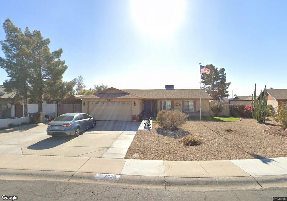
7623 W Mescal St Peoria, AZ 85345
Estimated Value: $378,275 - $438,000
3
Beds
3
Baths
1,759
Sq Ft
$239/Sq Ft
Est. Value
About This Home
This home is located at 7623 W Mescal St, Peoria, AZ 85345 and is currently estimated at $419,569, approximately $238 per square foot. 7623 W Mescal St is a home located in Maricopa County with nearby schools including Peoria Elementary School, Peoria High School, and Academy of Math & Science - Peoria Advanced.
Ownership History
Date
Name
Owned For
Owner Type
Purchase Details
Closed on
Jul 8, 2020
Sold by
Quealy Jeffrey and Quealy Lynne A
Bought by
Quealy Jeff and Quealy Lynne
Current Estimated Value
Purchase Details
Closed on
Dec 11, 2002
Sold by
Diaz Clement J and Diaz Elizabeth A
Bought by
Queally Jeffrey and Queally Lynne A
Home Financials for this Owner
Home Financials are based on the most recent Mortgage that was taken out on this home.
Original Mortgage
$132,050
Outstanding Balance
$56,354
Interest Rate
6.15%
Mortgage Type
New Conventional
Estimated Equity
$363,215
Create a Home Valuation Report for This Property
The Home Valuation Report is an in-depth analysis detailing your home's value as well as a comparison with similar homes in the area
Home Values in the Area
Average Home Value in this Area
Purchase History
| Date | Buyer | Sale Price | Title Company |
|---|---|---|---|
| Quealy Jeff | -- | None Available | |
| Queally Jeffrey | $139,000 | Capital Title Agency Inc |
Source: Public Records
Mortgage History
| Date | Status | Borrower | Loan Amount |
|---|---|---|---|
| Open | Queally Jeffrey | $132,050 |
Source: Public Records
Tax History Compared to Growth
Tax History
| Year | Tax Paid | Tax Assessment Tax Assessment Total Assessment is a certain percentage of the fair market value that is determined by local assessors to be the total taxable value of land and additions on the property. | Land | Improvement |
|---|---|---|---|---|
| 2025 | $1,097 | $14,487 | -- | -- |
| 2024 | $1,111 | $13,797 | -- | -- |
| 2023 | $1,111 | $30,550 | $6,110 | $24,440 |
| 2022 | $1,088 | $23,730 | $4,740 | $18,990 |
| 2021 | $1,164 | $21,900 | $4,380 | $17,520 |
| 2020 | $1,175 | $20,120 | $4,020 | $16,100 |
| 2019 | $1,137 | $18,600 | $3,720 | $14,880 |
| 2018 | $1,100 | $17,500 | $3,500 | $14,000 |
| 2017 | $1,100 | $14,320 | $2,860 | $11,460 |
| 2016 | $1,089 | $13,780 | $2,750 | $11,030 |
| 2015 | $1,016 | $12,660 | $2,530 | $10,130 |
Source: Public Records
Map
Nearby Homes
- 11221 N 77th Ave
- 11231 N 77th Dr
- 7545 W Jenan Dr
- 11640 N 74th Dr
- 10955 N 79th Ave Unit 163
- 10955 N 79th Ave Unit 113
- 10955 N 79th Ave Unit 60
- 10955 N 79th Ave Unit 40
- 10955 N 79th Ave Unit 179
- 10955 N 79th Ave Unit 147
- 7332 W Desert Cove Ave
- 7318 W Greer Ave
- 7810 W Peoria Ave Unit 174
- 7810 W Peoria Ave Unit 79
- 7810 W Peoria Ave Unit 121
- 7810 W Peoria Ave Unit 74
- 7810 W Peoria Ave Unit 98
- 7810 W Peoria Ave Unit 166
- 7810 W Peoria Ave Unit 85
- 11507 N 79th Dr
- 7615 W Mescal St
- 7631 W Mescal St
- 7631 W Mescal St
- 11113 N 76th Dr
- 11126 N 76th Dr
- 7624 W Mescal St
- 11102 N 76th Ave
- 11112 N 76th Ave
- 11212 N 76th Dr
- 7616 W Mescal St
- 11042 N 76th Ave
- 11122 N 76th Ave
- 11222 N 76th Dr
- 11120 N 76th Dr
- 11107 N 76th Dr
- 11032 N 76th Ave
- 7632 W Mescal St
- 7625 W Yucca St
- 7617 W Yucca St
- 7554 W Mescal St