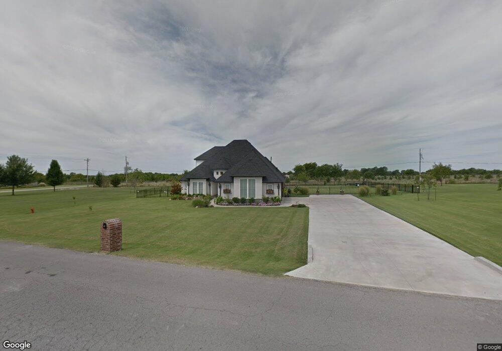
7634 N 181st East Ave Owasso, OK 74055
Estimated Value: $501,000 - $572,000
4
Beds
3
Baths
2,876
Sq Ft
$188/Sq Ft
Est. Value
About This Home
This home is located at 7634 N 181st East Ave, Owasso, OK 74055 and is currently estimated at $539,508, approximately $187 per square foot. 7634 N 181st East Ave is a home with nearby schools including Stone Canyon Elementary School, Owasso 6th Grade Center, and Owasso 8th Grade Center.
Ownership History
Date
Name
Owned For
Owner Type
Purchase Details
Closed on
Feb 6, 2024
Sold by
Bernal Jose A
Bought by
Bernal Christy E
Current Estimated Value
Purchase Details
Closed on
Sep 26, 2014
Sold by
Tyner Homes Llc
Bought by
Bernal Jose Alfredo
Purchase Details
Closed on
Feb 19, 2014
Sold by
Chute Derek L & Shelly Y Trust
Purchase Details
Closed on
Sep 1, 2011
Sold by
Chute Derek L and Chute Shelly Y
Bought by
Chute Derek L and Chute Shelly Y
Purchase Details
Closed on
Sep 14, 2010
Sold by
Jacobs Roy L
Purchase Details
Closed on
Jul 18, 2007
Sold by
Sokolosky Phyllis J and Sokolosky M D
Bought by
Jacobs Roy L and Jacobs Pong Sim
Create a Home Valuation Report for This Property
The Home Valuation Report is an in-depth analysis detailing your home's value as well as a comparison with similar homes in the area
Home Values in the Area
Average Home Value in this Area
Purchase History
| Date | Buyer | Sale Price | Title Company |
|---|---|---|---|
| Bernal Christy E | -- | None Listed On Document | |
| Bernal Jose Alfredo | $348,000 | -- | |
| -- | $50,000 | -- | |
| Chute Derek L | -- | None Available | |
| -- | $40,000 | -- | |
| Jacobs Roy L | $39,520 | None Available |
Source: Public Records
Tax History Compared to Growth
Tax History
| Year | Tax Paid | Tax Assessment Tax Assessment Total Assessment is a certain percentage of the fair market value that is determined by local assessors to be the total taxable value of land and additions on the property. | Land | Improvement |
|---|---|---|---|---|
| 2025 | $5,072 | $48,236 | $7,978 | $40,258 |
| 2024 | $5,072 | $46,831 | $6,416 | $40,415 |
| 2023 | $5,072 | $45,467 | $5,871 | $39,596 |
| 2022 | $4,857 | $44,143 | $5,500 | $38,643 |
| 2021 | $4,661 | $42,857 | $5,500 | $37,357 |
| 2020 | $4,517 | $42,521 | $5,500 | $37,021 |
| 2019 | $4,386 | $40,397 | $5,500 | $34,897 |
| 2018 | $4,318 | $41,089 | $5,500 | $35,589 |
| 2017 | $4,321 | $40,753 | $5,500 | $35,253 |
| 2016 | $4,206 | $39,664 | $5,500 | $34,164 |
| 2015 | $4,236 | $38,509 | $5,500 | $33,009 |
| 2014 | $533 | $4,851 | $4,851 | $0 |
Source: Public Records
Map
Nearby Homes
- 17798 E Anthem Ridge Rd
- 17401 E 78th St N
- 8219 N 175th East Ave
- 18894 E 80th St N
- 18934 Chickadee Ct
- 19433 E 73rd Place N
- 6940 N Garden Stone Ln
- 18533 E Crooked Oak Dr
- 6568 N Blue Sage Dr
- 19425 E 69th St N
- 17822 E Patriot Dr
- 18420 E Persimmon Ln
- 17862 E Patriot Dr
- 17762 E Patriot Dr
- 17823 E White Tail Cove
- 19460 E Boulder Dr
- 6407 N Blue Sage Dr
- Laredo Plan at Stone Creek
- Dean Plan at Stone Creek
- Cali Plan at Stone Creek
- 7634 N 181st East Ave
- 7676 N 181st East Ave
- 7722 N 181st East Ave
- 18217 E 76th St N
- 18181 E 76th St N
- 18311 E 76th St N
- 0 E 112th St Unit 2325621
- 0 E 112th St Unit 1931204
- 0 E 112th St Unit 2114679
- 7764 N 181st East Ave
- 18313 E 76th St N
- 7808 N 181st East Ave
- 18321 E 76th St N
- 7850 N 181st East Ave
- 18413 E 76th St N
- 18319 E 76th St N
- 18513 E 76th St N
- 18132 E 79th St N
- 18074 E 79th St N
- 18026 E 79th St N