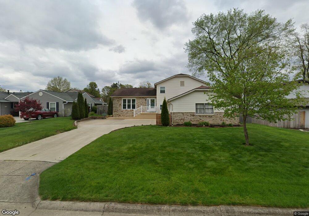
764 Hampton Rd S Newark, OH 43055
Estimated Value: $324,000 - $359,000
4
Beds
2
Baths
2,477
Sq Ft
$137/Sq Ft
Est. Value
About This Home
This home is located at 764 Hampton Rd S, Newark, OH 43055 and is currently estimated at $339,022, approximately $136 per square foot. 764 Hampton Rd S is a home located in Licking County with nearby schools including John Clem Elementary School, Liberty Middle School, and Newark High School.
Ownership History
Date
Name
Owned For
Owner Type
Purchase Details
Closed on
Jun 27, 2002
Sold by
Walker Eleanore F
Bought by
Woolard Brian S and Woolard Joyce
Current Estimated Value
Home Financials for this Owner
Home Financials are based on the most recent Mortgage that was taken out on this home.
Original Mortgage
$130,452
Outstanding Balance
$56,163
Interest Rate
6.93%
Mortgage Type
FHA
Estimated Equity
$282,859
Create a Home Valuation Report for This Property
The Home Valuation Report is an in-depth analysis detailing your home's value as well as a comparison with similar homes in the area
Home Values in the Area
Average Home Value in this Area
Purchase History
| Date | Buyer | Sale Price | Title Company |
|---|---|---|---|
| Woolard Brian S | $132,500 | -- |
Source: Public Records
Mortgage History
| Date | Status | Borrower | Loan Amount |
|---|---|---|---|
| Open | Woolard Brian S | $130,452 |
Source: Public Records
Tax History
| Year | Tax Paid | Tax Assessment Tax Assessment Total Assessment is a certain percentage of the fair market value that is determined by local assessors to be the total taxable value of land and additions on the property. | Land | Improvement |
|---|---|---|---|---|
| 2024 | $3,314 | $92,720 | $20,970 | $71,750 |
| 2023 | $3,308 | $92,720 | $20,970 | $71,750 |
| 2022 | $2,731 | $68,150 | $12,360 | $55,790 |
| 2021 | $2,864 | $68,150 | $12,360 | $55,790 |
| 2020 | $2,929 | $68,150 | $12,360 | $55,790 |
| 2019 | $2,322 | $52,020 | $12,360 | $39,660 |
| 2018 | $2,324 | $0 | $0 | $0 |
| 2017 | $2,226 | $0 | $0 | $0 |
| 2016 | $2,179 | $0 | $0 | $0 |
| 2015 | $2,226 | $0 | $0 | $0 |
| 2014 | $2,852 | $0 | $0 | $0 |
| 2013 | $2,172 | $0 | $0 | $0 |
Source: Public Records
Map
Nearby Homes
- 731 Grafton Rd
- 189 N Quentin Rd
- 32 Cottage St
- 158 English Ave
- 655 Evans St
- 988 Mount Vernon Rd
- 464 Moull St
- 567 Kibler Ave
- 20 Cherry St
- 508 Moull St
- 54 E Stevens St
- 584 Moull St Unit A
- 24 Elizabeth St
- 188 Meadow Dr
- 184 Meadow Dr
- 11 Waterworks Rd
- 739 Meadow Dr
- 441 Mount Vernon Rd
- 160 E Channel St
- 122 W Shields St
- 760 Hampton Rd S
- 768 Hampton Rd S
- 755 Towne Krier Ct
- 756 Hampton Rd S
- 772 Hampton Rd S
- 745 Towne Krier Ct
- 773 Hampton Rd S
- 765 Towne Krier Ct
- 750 S Hampton Rd
- 750 Hampton Rd S
- 776 Hampton Rd S
- 771 Plymouth Place
- 775 Hampton Rd S
- 753 Coventry Cir
- 735 Towne Krier Ct
- 759 Plymouth Place
- 754 Towne Krier Ct
- 744 Hampton Rd S
- 769 Plymouth Place
- 225 Stare Rd