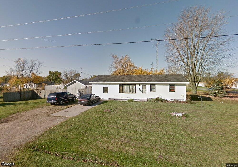
764 N Wells Ave Benton Harbor, MI 49022
Estimated Value: $31,000
--
Bed
--
Bath
--
Sq Ft
6,229
Sq Ft Lot
About This Home
This home is located at 764 N Wells Ave, Benton Harbor, MI 49022 and is currently estimated at $31,000. 764 N Wells Ave is a home located in Berrien County with nearby schools including Fair Plain Middle School, Benton Harbor High School, and Benton Harbor Charter School Academy.
Ownership History
Date
Name
Owned For
Owner Type
Purchase Details
Closed on
May 19, 2021
Sold by
Beach House Rentals Llc
Bought by
Echols Shekia
Current Estimated Value
Purchase Details
Closed on
Oct 21, 2008
Sold by
Lannert Barbara A
Bought by
Beach House Rentals Llc
Purchase Details
Closed on
Feb 18, 2004
Sold by
Jones Larry
Bought by
Miller Jones Elizabeth R
Purchase Details
Closed on
Nov 25, 2003
Sold by
Wolf William A
Bought by
Miller Jones Elizabeth and Jones Larry
Purchase Details
Closed on
May 2, 2000
Purchase Details
Closed on
Feb 22, 1999
Create a Home Valuation Report for This Property
The Home Valuation Report is an in-depth analysis detailing your home's value as well as a comparison with similar homes in the area
Home Values in the Area
Average Home Value in this Area
Purchase History
| Date | Buyer | Sale Price | Title Company |
|---|---|---|---|
| Echols Shekia | $29,500 | None Available | |
| Beach House Rentals Llc | -- | None Available | |
| Miller Jones Elizabeth R | -- | -- | |
| Miller Jones Elizabeth | -- | -- | |
| -- | -- | -- | |
| -- | -- | -- |
Source: Public Records
Tax History Compared to Growth
Tax History
| Year | Tax Paid | Tax Assessment Tax Assessment Total Assessment is a certain percentage of the fair market value that is determined by local assessors to be the total taxable value of land and additions on the property. | Land | Improvement |
|---|---|---|---|---|
| 2025 | $28 | $3,300 | $0 | $0 |
| 2024 | $27 | $2,800 | $0 | $0 |
| 2023 | $21 | $600 | $0 | $0 |
| 2022 | $24 | $400 | $0 | $0 |
| 2021 | $44 | $700 | $700 | $0 |
| 2020 | $44 | $700 | $0 | $0 |
| 2019 | $44 | $700 | $0 | $0 |
| 2018 | $71 | $2,900 | $0 | $0 |
| 2017 | $70 | $1,700 | $0 | $0 |
| 2016 | $69 | $1,700 | $0 | $0 |
| 2015 | $69 | $1,100 | $0 | $0 |
| 2014 | $73 | $1,300 | $0 | $0 |
Source: Public Records
Map
Nearby Homes
- 710 Buss Ave
- 419 Packard St
- 696 Highland Ave
- 992 Highland Ave
- 137 Cornelia St
- 806 Pitkins Ave
- 238 Pine St
- 6525 Territorial Rd
- 391 Pipestone St
- 1069 E Main St
- 363 Brunson Ave
- 416 E Britain Ave
- 378 Pipestone St
- 688 S Fair Ave
- 309 High St
- 234 Walnut St
- 470 N Mccord St
- 255 High St
- 1226 Chicago Ave
- 730 Superior St
- 772 N Wells Ave
- 780 Nate Wells Sr Dr
- 301 S Mccord St
- 781 Nathaniel Wells Sr Dr
- 273 S Mccord St
- 789 Nate Wells Sr Dr
- 794 N Wells Ave
- 765 E Vineyard Ave
- 795 Nate Wells Sr Dr
- 325 S Mccord St
- 802 Nate Wells Sr Dr
- 771 E Vineyard Ave
- 775 E Vineyard Ave
- 805 Nate Wells Sr Dr
- 259 S Mccord St
- 787 E Vineyard Ave
- 805 Nathaniel Wells Sr Dr
- 810 Nate Wells Sr Dr
- 795 E Vineyard Ave
- 803 E Vineyard Ave