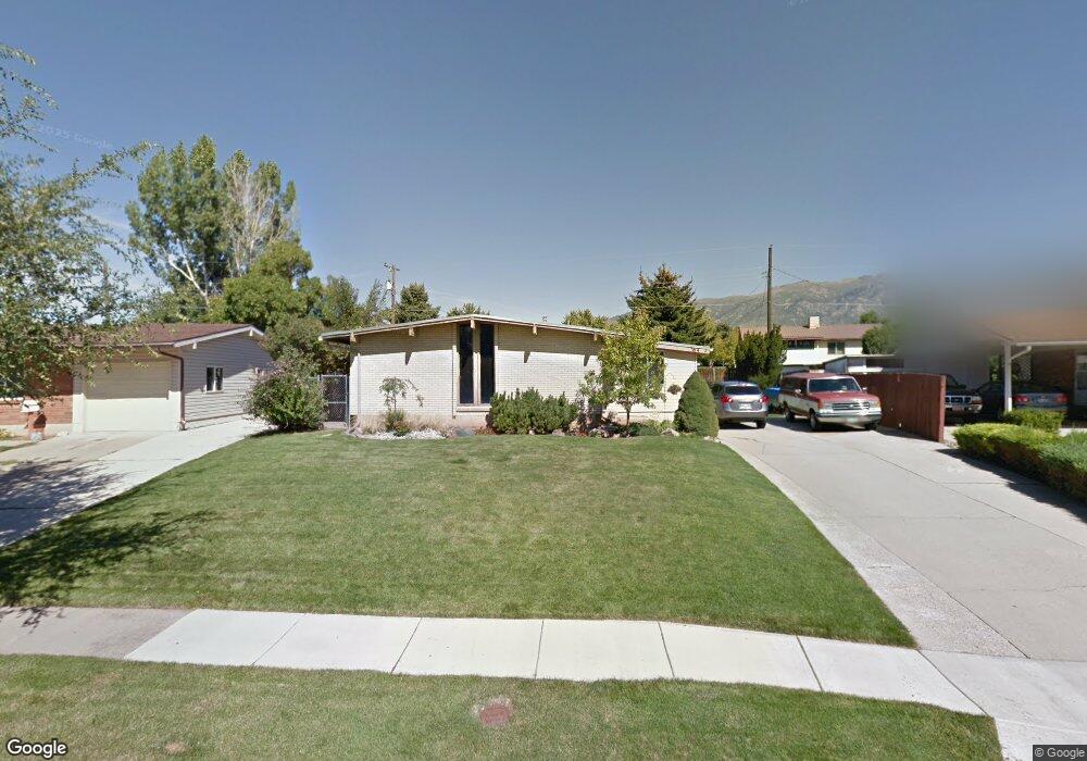
764 Sapphire Dr Layton, UT 84041
Estimated Value: $385,459 - $421,000
3
Beds
1
Bath
1,183
Sq Ft
$343/Sq Ft
Est. Value
About This Home
This home is located at 764 Sapphire Dr, Layton, UT 84041 and is currently estimated at $405,865, approximately $343 per square foot. 764 Sapphire Dr is a home located in Davis County with nearby schools including Crestview Elementary School, Central Davis Junior High School, and Layton High School.
Ownership History
Date
Name
Owned For
Owner Type
Purchase Details
Closed on
May 25, 2016
Sold by
Moore Patricia W and Moore Terilyn
Bought by
Hulse Vernon
Current Estimated Value
Purchase Details
Closed on
Oct 24, 2006
Sold by
Moore Thomas A and Moore Patricia W
Bought by
Moore Thomas A and Moore Patricia W
Home Financials for this Owner
Home Financials are based on the most recent Mortgage that was taken out on this home.
Original Mortgage
$96,000
Interest Rate
6.3%
Mortgage Type
Purchase Money Mortgage
Create a Home Valuation Report for This Property
The Home Valuation Report is an in-depth analysis detailing your home's value as well as a comparison with similar homes in the area
Home Values in the Area
Average Home Value in this Area
Purchase History
We collect this data history from publicly available records. To have your information removed, we recommend requesting removal directly through your county’s website.
| Date | Buyer | Sale Price | Title Company |
|---|---|---|---|
| Hulse Vernon | -- | Stewart Title | |
| Moore Thomas A | -- | Stewart Title | |
| Moore Thomas A | -- | Equity Title Ins Agency Inc |
Source: Public Records
Mortgage History
We collect this data history from publicly available records. To have your information removed, we recommend requesting removal directly through your county’s website.
| Date | Status | Borrower | Loan Amount |
|---|---|---|---|
| Previous Owner | Moore Thomas A | $96,000 |
Source: Public Records
Tax History
| Year | Tax Paid | Tax Assessment Tax Assessment Total Assessment is a certain percentage of the fair market value that is determined by local assessors to be the total taxable value of land and additions on the property. | Land | Improvement |
|---|---|---|---|---|
| 2025 | $1,871 | $196,350 | $99,756 | $96,594 |
| 2024 | $1,800 | $190,300 | $116,370 | $73,930 |
| 2023 | $1,690 | $315,000 | $139,598 | $175,402 |
| 2022 | $1,777 | $179,850 | $73,434 | $106,416 |
| 2021 | $1,630 | $246,000 | $102,026 | $143,974 |
| 2020 | $1,471 | $213,000 | $86,260 | $126,740 |
| 2019 | $1,459 | $207,000 | $82,304 | $124,696 |
| 2018 | $1,306 | $186,000 | $82,304 | $103,696 |
| 2016 | $1,116 | $81,950 | $26,028 | $55,922 |
| 2015 | $1,043 | $72,710 | $26,028 | $46,682 |
| 2014 | $1,107 | $78,906 | $26,028 | $52,878 |
| 2013 | -- | $74,485 | $18,612 | $55,873 |
Source: Public Records
Map
Nearby Homes
- 181 W Francis Ave
- 31 W Gordon Ave
- 929 Amethyst St
- 930 Amethyst St
- 104 W 525 N
- 962 N Laverde Ave W
- 972 La Verde St
- 184 E 1150 N
- 489 Owens St
- 367 Hawthorne Dr
- 350 Church St
- 651 Sherwood Dr
- 1282 N 25 E
- 789 N Hill Villa Dr
- 537 Kirk St
- 566 Miller Ave
- 831 Valeria Dr
- 437 E 1200 N
- 828 Valeria Dr
- 1421 N 125 E
Your Personal Tour Guide
Ask me questions while you tour the home.