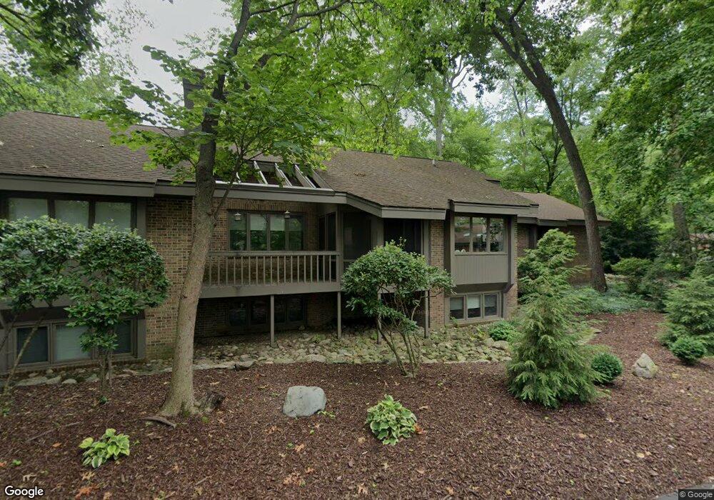
7648 E St Andrews Cir Portage, MI 49024
Estimated Value: $342,000 - $438,751
5
Beds
3
Baths
1,863
Sq Ft
$206/Sq Ft
Est. Value
About This Home
This home is located at 7648 E St Andrews Cir, Portage, MI 49024 and is currently estimated at $382,938, approximately $205 per square foot. 7648 E St Andrews Cir is a home located in Kalamazoo County with nearby schools including Moorsbridge Elementary School, Portage West Middle School, and Portage Central High School.
Ownership History
Date
Name
Owned For
Owner Type
Purchase Details
Closed on
Aug 20, 2020
Sold by
Kaufman Catherine and Pecock Maureen N
Bought by
Hendershott Levi and Hendershott Monica
Current Estimated Value
Purchase Details
Closed on
Oct 31, 2002
Sold by
Centers Kaye L
Bought by
Peacock Harold N and Peacock Maureen N
Home Financials for this Owner
Home Financials are based on the most recent Mortgage that was taken out on this home.
Original Mortgage
$70,000
Interest Rate
5.5%
Create a Home Valuation Report for This Property
The Home Valuation Report is an in-depth analysis detailing your home's value as well as a comparison with similar homes in the area
Home Values in the Area
Average Home Value in this Area
Purchase History
| Date | Buyer | Sale Price | Title Company |
|---|---|---|---|
| Hendershott Levi | $225,000 | None Available | |
| Peacock Harold N | $270,000 | -- |
Source: Public Records
Mortgage History
| Date | Status | Borrower | Loan Amount |
|---|---|---|---|
| Previous Owner | Peacock Harold N | $70,000 |
Source: Public Records
Tax History Compared to Growth
Tax History
| Year | Tax Paid | Tax Assessment Tax Assessment Total Assessment is a certain percentage of the fair market value that is determined by local assessors to be the total taxable value of land and additions on the property. | Land | Improvement |
|---|---|---|---|---|
| 2025 | $7,982 | $211,500 | $0 | $0 |
| 2024 | $7,027 | $184,800 | $0 | $0 |
| 2023 | $6,698 | $179,400 | $0 | $0 |
| 2022 | $7,237 | $159,500 | $0 | $0 |
| 2021 | $7,334 | $161,900 | $0 | $0 |
| 2020 | $5,538 | $189,100 | $0 | $0 |
| 2019 | $499 | $173,300 | $0 | $0 |
| 2018 | $0 | $159,000 | $0 | $0 |
| 2017 | $0 | $157,800 | $0 | $0 |
| 2016 | -- | $147,000 | $0 | $0 |
| 2015 | -- | $129,700 | $0 | $0 |
| 2014 | -- | $112,500 | $0 | $0 |
Source: Public Records
Map
Nearby Homes
- 3653 Tartan Cir
- 7922 Kilmory Cir
- 7961 Kilmory Cir
- 8030 Wimbledon Dr Unit 35
- 4788 Norfolk Cir
- 7236 Hampstead Ln Unit 18
- 7481 Turnberry Ct
- 7464 Saint George Cir
- 7639 Dunross Dr
- 3320 Scots Pine Way Unit 2
- 3737 Bellflower Dr
- 7951 S 12th St
- 3522 Bellflower Dr
- 4280 Romence Rd
- 3638 Bellflower Dr
- 7873 Shepherds Glen Ct
- 6876 Towhee St
- 2600 W Centre Ave Unit +/- 1 Acre
- 2351 W Centre Ave
- 2076 Lion Gate Dr
- 7648 E Saint Andrews Cir Unit 2
- 7648 E Street Andrews Cir
- 7640 E Street Andrews Cir
- 7640 E Saint Andrews Cir Unit 1
- 7646 E Street Andrews Cir
- 7674 E Street Andrews Cir
- 7672 E Street Andrews Cir Unit 2A
- 7676 E Saint Andrews Cir
- 7676 E St Andrews Cir
- 7676 E Saint Andrews Cir
- 7672 E Saint Andrews Cir
- 7646 W Saint Andrews Cir Unit 4B8
- 7646 W Street Andrews Cir
- 7688 E Street Andrews Cir
- 7630 W Street Andrews Cir
- 7630 W Saint Andrews Cir
- 7646 W St Andrews Cir
- 7596 Oak Shore Dr S
- 7683 W Saint Andrews Cir
- 7683 W Street Andrews Cir