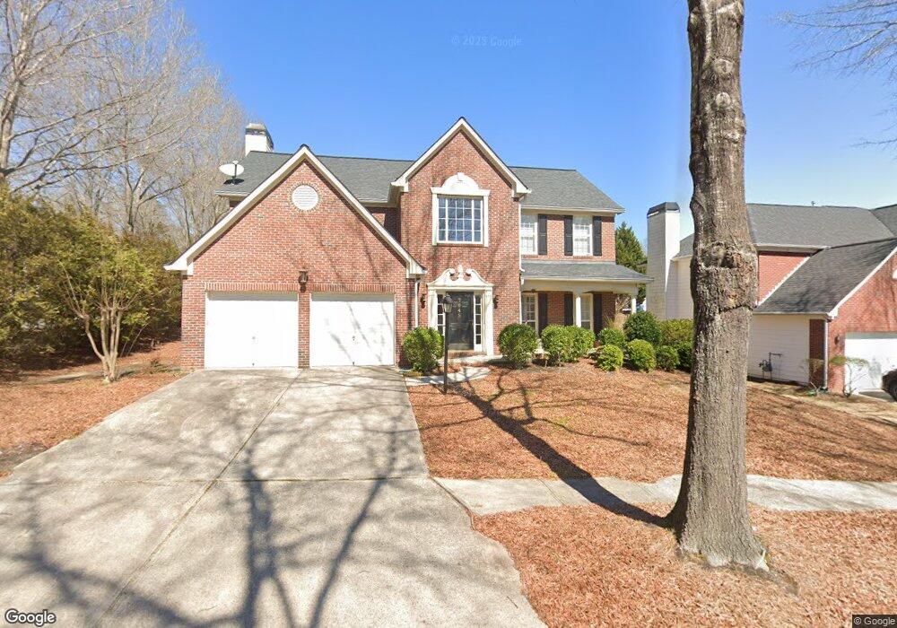
7649 Cole Ln Unit 1C Atlanta, GA 30349
Estimated Value: $362,114 - $418,000
4
Beds
3
Baths
2,585
Sq Ft
$147/Sq Ft
Est. Value
About This Home
This home is located at 7649 Cole Ln Unit 1C, Atlanta, GA 30349 and is currently estimated at $379,279, approximately $146 per square foot. 7649 Cole Ln Unit 1C is a home located in Fulton County with nearby schools including Cliftondale Elementary School, Renaissance Middle School, and Langston Hughes High School.
Ownership History
Date
Name
Owned For
Owner Type
Purchase Details
Closed on
Feb 16, 2001
Sold by
Ryland Group Inc
Bought by
Davis Marian P
Current Estimated Value
Home Financials for this Owner
Home Financials are based on the most recent Mortgage that was taken out on this home.
Original Mortgage
$150,050
Outstanding Balance
$53,957
Interest Rate
7.02%
Mortgage Type
New Conventional
Estimated Equity
$325,322
Create a Home Valuation Report for This Property
The Home Valuation Report is an in-depth analysis detailing your home's value as well as a comparison with similar homes in the area
Home Values in the Area
Average Home Value in this Area
Purchase History
| Date | Buyer | Sale Price | Title Company |
|---|---|---|---|
| Davis Marian P | $187,600 | -- |
Source: Public Records
Mortgage History
| Date | Status | Borrower | Loan Amount |
|---|---|---|---|
| Open | Davis Marian P | $150,050 |
Source: Public Records
Tax History Compared to Growth
Tax History
| Year | Tax Paid | Tax Assessment Tax Assessment Total Assessment is a certain percentage of the fair market value that is determined by local assessors to be the total taxable value of land and additions on the property. | Land | Improvement |
|---|---|---|---|---|
| 2025 | $1,707 | $142,960 | $32,920 | $110,040 |
| 2023 | $4,098 | $145,200 | $32,920 | $112,280 |
| 2022 | $1,588 | $129,480 | $28,240 | $101,240 |
| 2021 | $1,551 | $93,360 | $19,560 | $73,800 |
| 2020 | $1,520 | $88,120 | $17,000 | $71,120 |
| 2019 | $1,945 | $85,120 | $19,720 | $65,400 |
| 2018 | $1,925 | $65,680 | $13,080 | $52,600 |
| 2017 | $1,013 | $41,920 | $8,640 | $33,280 |
| 2016 | $1,011 | $41,920 | $8,640 | $33,280 |
| 2015 | $1,014 | $41,920 | $8,640 | $33,280 |
| 2014 | $1,043 | $41,920 | $8,640 | $33,280 |
Source: Public Records
Map
Nearby Homes
- 7656 Cole Ln
- 7648 Cole Ln Unit 1C
- 7425 Thoreau Cir
- 733 Miller Run
- 0 W Stubbs Rd Unit (11.4 ACRES)
- 0 W Stubbs Rd Unit 7487198
- 7280 Wright Dr Unit 12
- 2980 Oxford Rd
- 3495 Davis Blvd
- 3185 Highgreen Trail
- 3876 Margaux Dr
- 2970 Oxford Rd
- 3912 Margaux Dr
- 315 Amhurst Pkwy
- 3835 Kastler Dr
- 260 Redding Ridge
- 7192 Linden Dr
- 7645 Cole Ln Unit 1C
- 7350 Thoreau Cir
- 7641 Cole Ln Unit 1C
- 430 Fitzgerald Place
- 430 Fitzgerald Place Unit 430
- 7340 Thoreau Cir
- 420 Fitzgerald Place Unit 1C
- 440 Fitzgerald Place Unit 1C
- 7668 Cole Ln
- 7330 Thoreau Cir
- 410 Fitzgerald Place
- 7664 Cole Ln
- 7637 Cole Ln
- 450 Fitzgerald Place Unit 1C
- 7660 Cole Ln
- 7320 Thoreau Cir
- 400 Fitzgerald Place
- 7633 Cole Ln
- 748 Walden Blvd Unit 1A
- 744 Walden Blvd