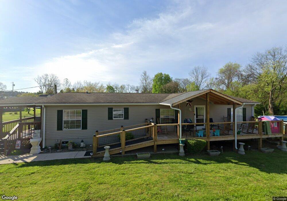
765 Circle Dr Morristown, TN 37813
Estimated Value: $193,000 - $212,000
Studio
2
Baths
1,560
Sq Ft
$130/Sq Ft
Est. Value
About This Home
This home is located at 765 Circle Dr, Morristown, TN 37813 and is currently estimated at $202,265, approximately $129 per square foot. 765 Circle Dr is a home located in Hamblen County with nearby schools including Witt Elementary School, Lincoln Heights Middle School, and Morristown West High School.
Ownership History
Date
Name
Owned For
Owner Type
Purchase Details
Closed on
Oct 23, 2001
Sold by
Guy Greene
Bought by
Thompson James
Current Estimated Value
Home Financials for this Owner
Home Financials are based on the most recent Mortgage that was taken out on this home.
Original Mortgage
$68,340
Outstanding Balance
$25,867
Interest Rate
6.74%
Mortgage Type
VA
Estimated Equity
$176,398
Purchase Details
Closed on
Jul 10, 1999
Sold by
Smellie Annie
Bought by
Guy Greene
Home Financials for this Owner
Home Financials are based on the most recent Mortgage that was taken out on this home.
Original Mortgage
$53,910
Interest Rate
7.51%
Purchase Details
Closed on
Mar 6, 1998
Bought by
Smellie Annie
Purchase Details
Closed on
Oct 6, 1995
Bought by
Cadwallader Allan and Cadwallader Karolyn
Create a Home Valuation Report for This Property
The Home Valuation Report is an in-depth analysis detailing your home's value as well as a comparison with similar homes in the area
Home Values in the Area
Average Home Value in this Area
Purchase History
| Date | Buyer | Sale Price | Title Company |
|---|---|---|---|
| Thompson James | $67,000 | -- | |
| Guy Greene | $59,900 | -- | |
| Smellie Annie | $4,200 | -- | |
| Cadwallader Allan | $4,800 | -- |
Source: Public Records
Mortgage History
| Date | Status | Borrower | Loan Amount |
|---|---|---|---|
| Open | Cadwallader Allan | $68,340 | |
| Previous Owner | Cadwallader Allan | $53,910 |
Source: Public Records
Tax History
| Year | Tax Paid | Tax Assessment Tax Assessment Total Assessment is a certain percentage of the fair market value that is determined by local assessors to be the total taxable value of land and additions on the property. | Land | Improvement |
|---|---|---|---|---|
| 2025 | $683 | $46,450 | $6,875 | $39,575 |
| 2024 | $436 | $22,125 | $4,325 | $17,800 |
| 2023 | $436 | $22,125 | $0 | $0 |
| 2022 | $408 | $20,725 | $4,325 | $16,400 |
| 2021 | $408 | $20,725 | $4,325 | $16,400 |
| 2020 | $408 | $20,725 | $4,325 | $16,400 |
| 2019 | $366 | $17,200 | $3,975 | $13,225 |
| 2018 | $366 | $17,200 | $3,975 | $13,225 |
| 2017 | $366 | $17,200 | $3,975 | $13,225 |
| 2016 | $342 | $17,200 | $3,975 | $13,225 |
| 2015 | $318 | $17,200 | $3,975 | $13,225 |
| 2014 | -- | $17,200 | $3,975 | $13,225 |
| 2013 | -- | $18,450 | $0 | $0 |
Source: Public Records
Map
Nearby Homes
- 271 Sequoyah Dr
- 201 Sequoyah Dr
- 114 Sequoyah Dr
- 701 Old Witt Rd
- 701 Old Witt Rd Unit 1
- 586 Randolph Dr
- 5056 Spencer Hale Rd
- 2041 Witt Rd
- 4956 Southfork Cir
- 848 Spencer Hale Rd
- 2851 Coffey Rd
- 3084 Hardy Rd
- 2890 Lakins Dr
- 453 Statem Gap Rd
- 3017 Hardy Rd
- 1500 S Davy Crockett Pkwy
- 2895 Coffey Rd
- 0 Old White Pine Rd
- 1875 Roe Junction Rd
- 1160 Statem Gap Rd
Your Personal Tour Guide
Ask me questions while you tour the home.