Estimated Value: $166,000 - $303,000
3
Beds
1
Bath
1,162
Sq Ft
$190/Sq Ft
Est. Value
About This Home
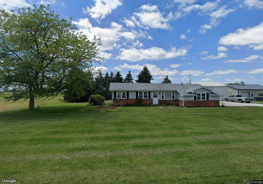
This home is located at 7653 County Road 10, Delta, OH 43515 and is currently estimated at $220,859, approximately $190 per square foot. 7653 County Road 10 is a home located in Fulton County with nearby schools including Delta Elementary School, Pike-Delta-York Middle School, and Pike-Delta-York High School.
Ownership History
Date
Name
Owned For
Owner Type
Purchase Details
Closed on
Sep 9, 2009
Sold by
Carr Beth A and Carr Phillip
Bought by
Falor Michael B
Current Estimated Value
Home Financials for this Owner
Home Financials are based on the most recent Mortgage that was taken out on this home.
Original Mortgage
$135,000
Outstanding Balance
$88,871
Interest Rate
5.32%
Mortgage Type
Credit Line Revolving
Estimated Equity
$131,988
Purchase Details
Closed on
Apr 14, 2008
Sold by
Falor Janet Sue
Bought by
Falor Lois L
Purchase Details
Closed on
Jan 1, 1990
Bought by
Falor Michael B and Falor Linda
Create a Home Valuation Report for This Property
The Home Valuation Report is an in-depth analysis detailing your home's value as well as a comparison with similar homes in the area
Home Values in the Area
Average Home Value in this Area
Purchase History
| Date | Buyer | Sale Price | Title Company |
|---|---|---|---|
| Falor Michael B | $133,000 | Attorney | |
| Falor Lois L | -- | None Available | |
| Falor Michael B | -- | -- |
Source: Public Records
Mortgage History
| Date | Status | Borrower | Loan Amount |
|---|---|---|---|
| Open | Falor Michael B | $135,000 |
Source: Public Records
Tax History Compared to Growth
Tax History
| Year | Tax Paid | Tax Assessment Tax Assessment Total Assessment is a certain percentage of the fair market value that is determined by local assessors to be the total taxable value of land and additions on the property. | Land | Improvement |
|---|---|---|---|---|
| 2024 | $1,605 | $51,000 | $13,090 | $37,910 |
| 2023 | $1,610 | $51,000 | $13,090 | $37,910 |
| 2022 | $1,676 | $41,230 | $10,920 | $30,310 |
| 2021 | $1,744 | $41,230 | $10,920 | $30,310 |
| 2020 | $1,673 | $41,230 | $10,920 | $30,310 |
| 2019 | $1,433 | $37,560 | $9,870 | $27,690 |
| 2018 | $1,386 | $37,560 | $9,870 | $27,690 |
| 2017 | $1,404 | $37,560 | $9,870 | $27,690 |
| 2016 | $1,367 | $35,040 | $9,870 | $25,170 |
| 2015 | $1,300 | $35,040 | $9,870 | $25,170 |
| 2014 | $1,298 | $35,040 | $9,870 | $25,170 |
| 2013 | $1,458 | $37,840 | $9,660 | $28,180 |
Source: Public Records
Map
Nearby Homes
- 7620 County Road 12
- 7373 County Road 12
- 201 Elmwood Ave
- 308 Monroe St
- 207 Wood St
- 413 Fernwood St
- 421 Providence St
- 305 Mckinley St
- 518 Providence St
- 701 Palmwood St
- 703 Linwood Ave
- 0 County Road H
- 810 Greenview Ave
- 908 Fernwood St
- 8453 County Road 13
- 13242 Us Highway 20a
- 13354 U S 20a
- 1209 Apache Dr
- Integrity 1830 Plan at Arrowhead Trails
- integrity 2280 Plan at Arrowhead Trails
- 000 County Road 10
- 7761 County Road 10
- 7421 County Road 10
- 7393 County Road 10
- 9811 County Road H
- 9851 County Road H
- 9820 County Road H
- 9757 County Road H
- 10325 County Road H
- 9673 County Road H
- 9710 County Road H
- 9601 County Road H
- 8161 County Road 10
- 9636 County Road H
- 10400 County Road H
- 10467 County Road H
- 9967 Us Highway 20a
- 10105 County Road Hj
- 10251 County Road Hj
- 5388 Airport Hwy