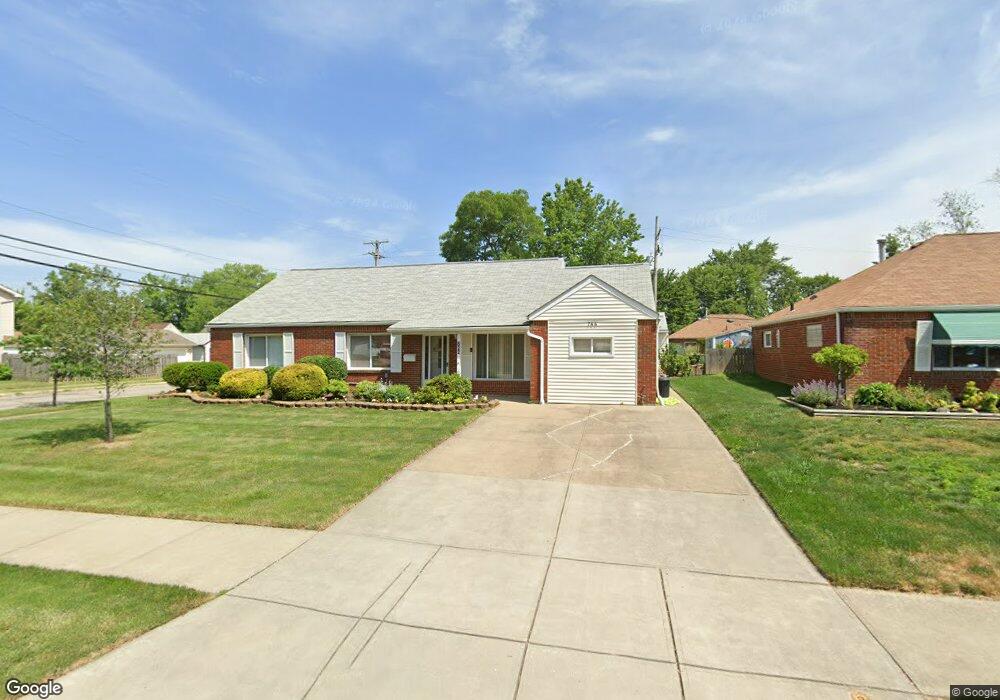
766 Hemlock Dr Euclid, OH 44132
Estimated Value: $192,556 - $215,000
3
Beds
2
Baths
2,241
Sq Ft
$91/Sq Ft
Est. Value
About This Home
This home is located at 766 Hemlock Dr, Euclid, OH 44132 and is currently estimated at $204,639, approximately $91 per square foot. 766 Hemlock Dr is a home located in Cuyahoga County with nearby schools including Shoreview Elementary School, Euclid High School, and Ss. Robert & William Catholic School.
Ownership History
Date
Name
Owned For
Owner Type
Purchase Details
Closed on
May 16, 1985
Sold by
Lewin William E
Bought by
Lewin Karen G
Current Estimated Value
Purchase Details
Closed on
Apr 15, 1977
Sold by
George Fred J and George Velma H
Bought by
Lewin William E
Purchase Details
Closed on
Jan 1, 1975
Bought by
George Fred J and George Velma H
Create a Home Valuation Report for This Property
The Home Valuation Report is an in-depth analysis detailing your home's value as well as a comparison with similar homes in the area
Home Values in the Area
Average Home Value in this Area
Purchase History
| Date | Buyer | Sale Price | Title Company |
|---|---|---|---|
| Lewin Karen G | -- | -- | |
| Lewin William E | $49,500 | -- | |
| George Fred J | -- | -- |
Source: Public Records
Tax History Compared to Growth
Tax History
| Year | Tax Paid | Tax Assessment Tax Assessment Total Assessment is a certain percentage of the fair market value that is determined by local assessors to be the total taxable value of land and additions on the property. | Land | Improvement |
|---|---|---|---|---|
| 2024 | $3,419 | $60,480 | $10,290 | $50,190 |
| 2023 | $3,087 | $45,680 | $9,100 | $36,580 |
| 2022 | $3,049 | $45,680 | $9,100 | $36,580 |
| 2021 | $3,395 | $45,680 | $9,100 | $36,580 |
| 2020 | $2,634 | $34,620 | $6,900 | $27,720 |
| 2019 | $2,386 | $98,900 | $19,700 | $79,200 |
| 2018 | $2,342 | $34,620 | $6,900 | $27,720 |
| 2017 | $2,420 | $30,420 | $5,500 | $24,920 |
| 2016 | $2,425 | $30,420 | $5,500 | $24,920 |
| 2015 | $2,253 | $30,420 | $5,500 | $24,920 |
| 2014 | $2,253 | $30,420 | $5,500 | $24,920 |
Source: Public Records
Map
Nearby Homes
- 780 E 266th St
- 712 E 266th St
- 27101 Zeman Ave
- 27190 Shoreview Ave
- 26430 Drakefield Ave
- 26471 Farringdon Ave
- 577 Sycamore Dr
- 559 Sycamore Dr
- 26351 Farringdon Ave
- 635 E 261st St
- 26268 Leslie Ave
- 640 E 261st St
- 29038 Fuller Ave
- 26471 Shoreview Ave
- 546 Walnut Dr
- 795 E 260th St
- 461 E 271st St
- 26171 Shoreview Ave
- 25750 Drakefield Ave
- 440 E 271st St
- 760 Hemlock Dr
- 27191 Gary Ave
- 727 Willow Dr
- 754 Hemlock Dr
- 754 Hemlock Dr Unit ID1061094P
- 721 Willow Dr
- 27171 Gary Ave
- 27190 Drakefield Ave
- 767 Hemlock Dr
- 759 Hemlock Dr
- 715 Willow Dr
- 750 Hemlock Dr
- 27190 Gary Ave
- 27170 Drakefield Ave
- 27151 Gary Ave
- 755 Hemlock Dr
- 27170 Gary Ave
- 27150 Drakefield Ave
- 709 Willow Dr
- 753 Hemlock Dr