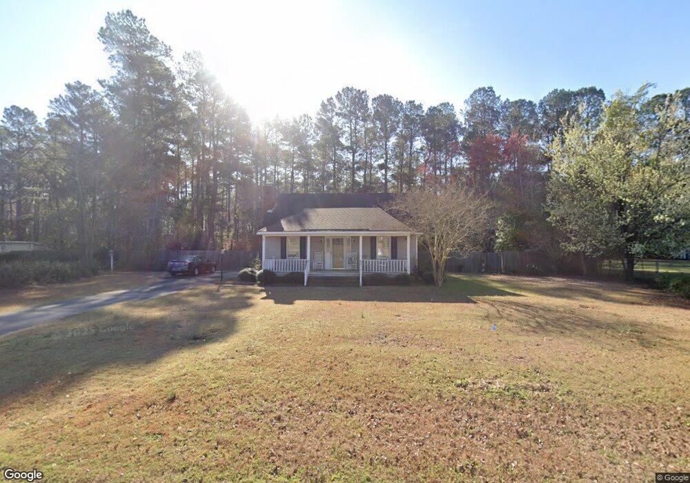
767 Dove Point Dr Orangeburg, SC 29118
Estimated Value: $182,000 - $239,000
3
Beds
2
Baths
1,214
Sq Ft
$165/Sq Ft
Est. Value
About This Home
This home is located at 767 Dove Point Dr, Orangeburg, SC 29118 and is currently estimated at $200,386, approximately $165 per square foot. 767 Dove Point Dr is a home located in Orangeburg County with nearby schools including Marshall Elementary School, Marshall Elementary, and William J. Clark Middle School.
Ownership History
Date
Name
Owned For
Owner Type
Purchase Details
Closed on
May 22, 2015
Sold by
Mcgannonin Daniel P
Bought by
Hallinquest Charles and Hallinquest Bernice
Current Estimated Value
Purchase Details
Closed on
Jul 14, 2005
Sold by
Lindler Glenda F and Whisenhunt Glenda F
Bought by
Mcgannon Daniel P
Home Financials for this Owner
Home Financials are based on the most recent Mortgage that was taken out on this home.
Original Mortgage
$73,750
Interest Rate
5.54%
Mortgage Type
New Conventional
Create a Home Valuation Report for This Property
The Home Valuation Report is an in-depth analysis detailing your home's value as well as a comparison with similar homes in the area
Home Values in the Area
Average Home Value in this Area
Purchase History
| Date | Buyer | Sale Price | Title Company |
|---|---|---|---|
| Hallinquest Charles | $118,000 | -- | |
| Mcgannon Daniel P | $109,900 | -- |
Source: Public Records
Mortgage History
| Date | Status | Borrower | Loan Amount |
|---|---|---|---|
| Previous Owner | Mcgannon Daniel P | $73,750 |
Source: Public Records
Tax History Compared to Growth
Tax History
| Year | Tax Paid | Tax Assessment Tax Assessment Total Assessment is a certain percentage of the fair market value that is determined by local assessors to be the total taxable value of land and additions on the property. | Land | Improvement |
|---|---|---|---|---|
| 2024 | $923 | $5,368 | $732 | $4,636 |
| 2023 | $739 | $4,176 | $692 | $3,484 |
| 2022 | $718 | $4,176 | $692 | $3,484 |
| 2021 | $710 | $4,176 | $692 | $3,484 |
| 2020 | $693 | $4,176 | $692 | $3,484 |
| 2019 | $697 | $4,176 | $692 | $3,484 |
| 2018 | $737 | $4,704 | $692 | $4,012 |
| 2017 | $709 | $4,704 | $0 | $0 |
| 2016 | $709 | $4,704 | $0 | $0 |
| 2015 | $581 | $6,240 | $0 | $0 |
| 2014 | $581 | $6,240 | $1,038 | $5,202 |
| 2013 | -- | $4,016 | $692 | $3,324 |
Source: Public Records
Map
Nearby Homes
- 779 Windmill Way
- 105 Kirkwood Ct
- 110 Kirkwood Ct
- 145 Tahoe Dr
- 155 Tahoe Dr
- 141 Tahoe Dr
- 137 Kirkwood Ct
- 106 Kirkwood Dr
- 102 Kirkwood Ct
- 167 Tahoe Dr
- 137 Tahoe Dr
- 106 Kirkwood Ct
- 163 Tahoe Dr
- 101 Kirkwood Dr
- HARRISON Plan at Mulberry Landing
- DEVON Plan at Mulberry Landing
- CAMERON Plan at Mulberry Landing
- ALLEX Plan at Mulberry Landing
- 113 Kirkwood Ct
- 170 Willow Bay Dr
- 753 Dove Point Dr
- 779 Dove Point Dr
- 778 Dove Point Dr
- 778 Dove Point Dr
- 778 Dove Point Dr
- 766 Dove Point Dr
- 741 Dove Point Dr
- 781 Dove Point Dr
- 780 Dove Point Dr
- 754 Dove Point Dr
- 788 Dove Point Dr
- 731 Dove Point Dr
- 797 Dove Point Dr
- 734 Dove Point Dr
- 767 Windmill Way
- 783 Windmill Way
- 755 Windmill Way
- 723 Dove Point Dr
- 789 Windmill Way
- 724 Dove Point Dr