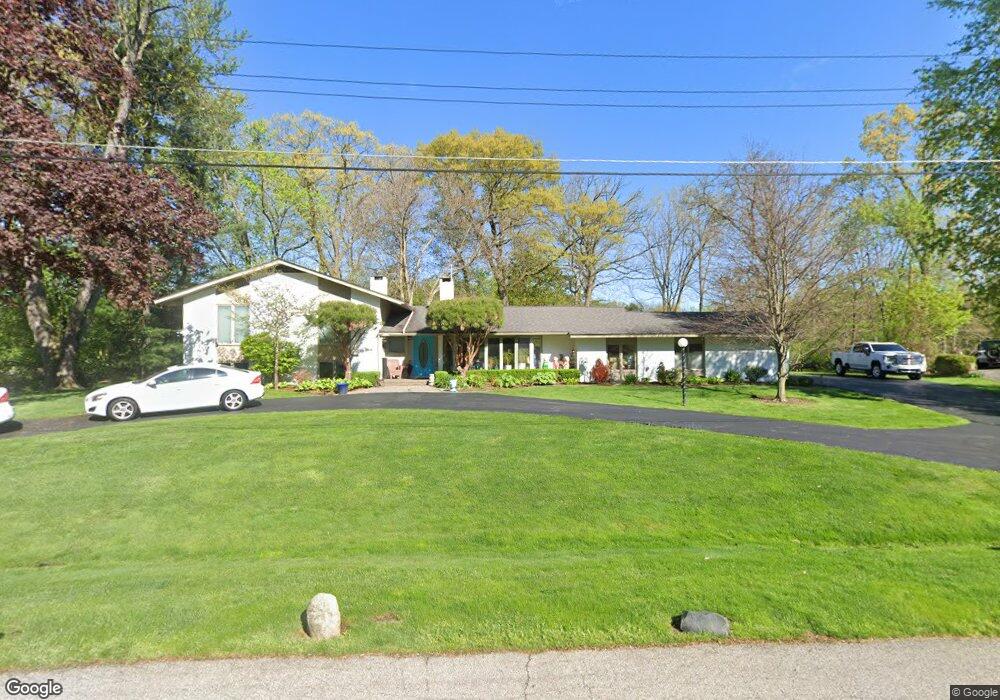
767 Robinhood Cir Bloomfield Hills, MI 48304
Estimated Value: $531,000 - $655,000
4
Beds
4
Baths
2,304
Sq Ft
$267/Sq Ft
Est. Value
About This Home
This home is located at 767 Robinhood Cir, Bloomfield Hills, MI 48304 and is currently estimated at $615,122, approximately $266 per square foot. 767 Robinhood Cir is a home located in Oakland County with nearby schools including Harlan Elementary School, Ernest W. Seaholm High School, and Academy of Sacred Heart.
Ownership History
Date
Name
Owned For
Owner Type
Purchase Details
Closed on
Nov 21, 2012
Sold by
Ellis Theodore Hoag and Dorothy H Ellis Living Trust
Bought by
Ellis Theodore Hoag and Theodore Hoag Ellis Revocable Trust
Current Estimated Value
Purchase Details
Closed on
Nov 8, 2000
Sold by
Ellis Dorothy H
Bought by
Dorothy H Ellis Tr
Purchase Details
Closed on
Jan 2, 1996
Sold by
Hoag Frank E
Bought by
Hoag Dorothy E
Create a Home Valuation Report for This Property
The Home Valuation Report is an in-depth analysis detailing your home's value as well as a comparison with similar homes in the area
Home Values in the Area
Average Home Value in this Area
Purchase History
| Date | Buyer | Sale Price | Title Company |
|---|---|---|---|
| Ellis Theodore Hoag | -- | None Available | |
| Dorothy H Ellis Tr | -- | -- | |
| Hoag Dorothy E | -- | -- |
Source: Public Records
Tax History Compared to Growth
Tax History
| Year | Tax Paid | Tax Assessment Tax Assessment Total Assessment is a certain percentage of the fair market value that is determined by local assessors to be the total taxable value of land and additions on the property. | Land | Improvement |
|---|---|---|---|---|
| 2024 | $2,969 | $258,130 | $0 | $0 |
| 2023 | $2,849 | $241,850 | $0 | $0 |
| 2022 | $4,823 | $226,550 | $0 | $0 |
| 2021 | $4,863 | $230,490 | $0 | $0 |
| 2020 | $2,737 | $216,490 | $0 | $0 |
| 2019 | $4,856 | $160,270 | $0 | $0 |
| 2018 | $4,819 | $160,930 | $0 | $0 |
| 2017 | $4,817 | $157,500 | $0 | $0 |
| 2016 | $4,896 | $152,880 | $0 | $0 |
| 2015 | -- | $137,930 | $0 | $0 |
| 2014 | -- | $119,470 | $0 | $0 |
| 2011 | -- | $116,080 | $0 | $0 |
Source: Public Records
Map
Nearby Homes
- 4731 Haddington Dr
- 2991 Lanergan Dr
- 2840 Bolingbroke Dr
- 2650 Binbrooke Dr
- 4144 Rouge Circle Dr
- 4389 Charing Way
- 0000 Brookdale Rd
- 4890 Charing Cross Rd
- 796 Rock Spring Rd
- 433 Whippers In Ct
- 2611 Tarragona Way
- 1048 Satterlee Rd
- 3826 Lakecrest Dr
- 1330 Oxford Rd
- 1333 N Adams Rd
- 170 Kirkwood Ct
- 3665 Estates Dr
- 5554 Pine Brooke Ct
- 680 Shepardbush St
- 654 Shepardbush St
- 759 Robinhood Cir
- 777 Robinhood Cir
- 788 Robinhood Cir
- 783 Robinhood Cir
- 752 Robinhood Cir
- 751 Robinhood Cir
- 796 Robinhood Cir
- 4567 Burnley Dr
- 4581 Burnley Dr
- 791 Robinhood Cir
- 728 Robinhood Cir
- 4595 Burnley Dr
- 4553 Burnley Dr
- 3821 N Adams Rd
- 743 Robinhood Cir
- 3841 N Adams Rd
- 4611 Burnley Dr
- 704 Robinhood Cir
- 4631 Burnley Dr
- 4651 Burnley Dr