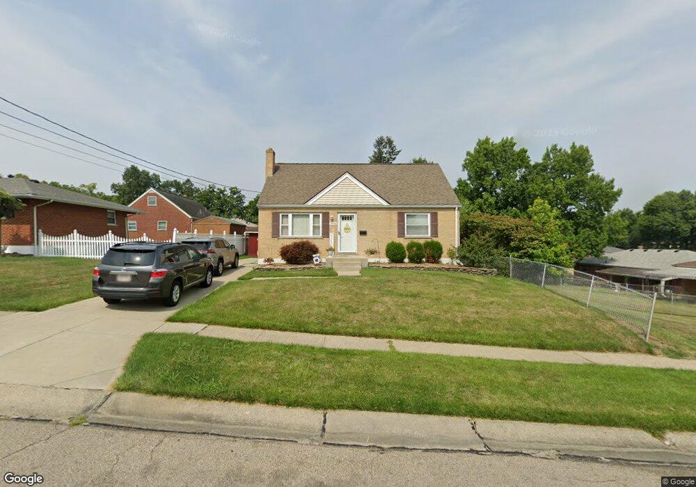
7679 Barjo Ln Cincinnati, OH 45239
Estimated Value: $200,297 - $245,000
4
Beds
1
Bath
1,683
Sq Ft
$129/Sq Ft
Est. Value
About This Home
This home is located at 7679 Barjo Ln, Cincinnati, OH 45239 and is currently estimated at $217,824, approximately $129 per square foot. 7679 Barjo Ln is a home located in Hamilton County with nearby schools including White Oak Middle School, Colerain High School, and Our Lady of Grace Catholic School.
Ownership History
Date
Name
Owned For
Owner Type
Purchase Details
Closed on
Dec 15, 1999
Sold by
Topper Gary C and Topper Sherrie L
Bought by
Hosbrook Sharon A
Current Estimated Value
Home Financials for this Owner
Home Financials are based on the most recent Mortgage that was taken out on this home.
Original Mortgage
$101,166
Outstanding Balance
$29,185
Interest Rate
7.7%
Mortgage Type
FHA
Estimated Equity
$188,639
Create a Home Valuation Report for This Property
The Home Valuation Report is an in-depth analysis detailing your home's value as well as a comparison with similar homes in the area
Home Values in the Area
Average Home Value in this Area
Purchase History
| Date | Buyer | Sale Price | Title Company |
|---|---|---|---|
| Hosbrook Sharon A | $102,000 | -- |
Source: Public Records
Mortgage History
| Date | Status | Borrower | Loan Amount |
|---|---|---|---|
| Open | Hosbrook Sharon A | $101,166 |
Source: Public Records
Tax History
| Year | Tax Paid | Tax Assessment Tax Assessment Total Assessment is a certain percentage of the fair market value that is determined by local assessors to be the total taxable value of land and additions on the property. | Land | Improvement |
|---|---|---|---|---|
| 2025 | $2,861 | $49,673 | $5,940 | $43,733 |
| 2024 | $2,652 | $49,673 | $5,940 | $43,733 |
| 2023 | $2,668 | $49,673 | $5,940 | $43,733 |
| 2022 | $2,472 | $37,531 | $5,446 | $32,085 |
| 2021 | $2,450 | $37,531 | $5,446 | $32,085 |
| 2020 | $2,476 | $37,531 | $5,446 | $32,085 |
| 2019 | $2,140 | $30,269 | $4,393 | $25,876 |
| 2018 | $1,920 | $30,269 | $4,393 | $25,876 |
| 2017 | $1,818 | $30,269 | $4,393 | $25,876 |
| 2016 | $1,784 | $29,299 | $4,480 | $24,819 |
| 2015 | $1,801 | $29,299 | $4,480 | $24,819 |
| 2014 | $1,804 | $29,299 | $4,480 | $24,819 |
| 2013 | $1,866 | $31,847 | $4,869 | $26,978 |
Source: Public Records
Map
Nearby Homes
- 3408 Rocker Dr
- 3360 Alexis Rd
- 3464 Nandale Dr Unit 53
- 3329 Alexis Rd
- 3260 Harry Lee Ln
- 3693 W Galbraith Rd
- 3691 W Galbraith Rd
- 3701 W Galbraith Rd
- 8261 Cheviot Rd
- 6893 Newbridge Dr
- 3219 Banning Rd
- 3250 March Terrace
- 3860 Appletree Ct
- 3387 Lapland Dr
- 3663 Sandralin Dr
- 3937 Olde Savannah Dr Unit 3937
- 3181 Preserve Ln
- 3950 Olde Savannah Dr
- 6321 Duet Ln
- 3161 Preserve Ln Unit 3D
- 7647 Barjo Ln
- 3386 Lakemeadow Ct
- 3391 Nandale Dr
- 3397 Nandale Dr
- 3388 Lakemeadow Ct
- 3401 Nandale Dr
- 3392 Lakemeadow Ct
- 7678 Barjo Ln
- 3385 Nandale Dr
- 7656 Barjo Ln
- 3407 Nandale Dr
- 3383 Lakemeadow Ct
- 7636 Barjo Ln
- 7614 Barjo Ln
- 3394 Lakemeadow Ct
- 3387 Lakemeadow Ct
- 3379 Nandale Dr
- 3413 Nandale Dr
- 7573 Barjo Ln
- 7594 Barjo Ln