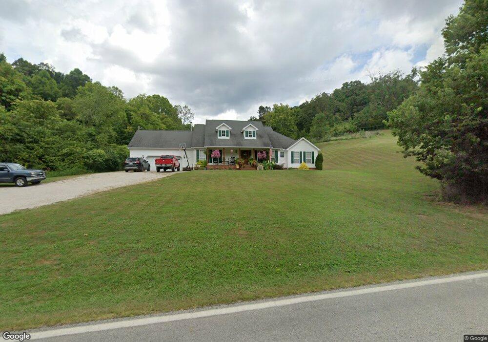
7685 State Route 243 South Point, OH 45680
Estimated Value: $293,000 - $358,956
3
Beds
3
Baths
2,180
Sq Ft
$153/Sq Ft
Est. Value
About This Home
This home is located at 7685 State Route 243, South Point, OH 45680 and is currently estimated at $333,319, approximately $152 per square foot. 7685 State Route 243 is a home located in Lawrence County with nearby schools including Dawson-Bryant Elementary School, Dawson-Bryant Middle School, and Dawson-Bryant High School.
Ownership History
Date
Name
Owned For
Owner Type
Purchase Details
Closed on
Oct 22, 1997
Sold by
Rice James E and Rice Betty D
Bought by
Riggs Gregory L and Riggs San
Current Estimated Value
Purchase Details
Closed on
Oct 8, 1997
Sold by
Rice James E and Rice Betty D
Bought by
Rice James E and Rice Betty D
Purchase Details
Closed on
Jun 27, 1997
Sold by
Rice James E and Rice Betty D
Bought by
Rice James E and Rice Betty D
Purchase Details
Closed on
May 12, 1993
Sold by
Rice Carl A and Rice James E
Bought by
Rice James E and Rice Betty D
Create a Home Valuation Report for This Property
The Home Valuation Report is an in-depth analysis detailing your home's value as well as a comparison with similar homes in the area
Home Values in the Area
Average Home Value in this Area
Purchase History
| Date | Buyer | Sale Price | Title Company |
|---|---|---|---|
| Riggs Gregory L | $45,000 | -- | |
| Rice James E | -- | -- | |
| Rice James E | -- | -- | |
| Rice James E | -- | -- |
Source: Public Records
Tax History Compared to Growth
Tax History
| Year | Tax Paid | Tax Assessment Tax Assessment Total Assessment is a certain percentage of the fair market value that is determined by local assessors to be the total taxable value of land and additions on the property. | Land | Improvement |
|---|---|---|---|---|
| 2024 | -- | $87,130 | $15,160 | $71,970 |
| 2023 | $2,254 | $87,130 | $15,160 | $71,970 |
| 2022 | $2,251 | $87,130 | $15,160 | $71,970 |
| 2021 | $1,942 | $71,490 | $11,520 | $59,970 |
| 2020 | $1,957 | $71,490 | $11,520 | $59,970 |
| 2019 | $1,949 | $71,490 | $11,520 | $59,970 |
| 2018 | $1,923 | $69,650 | $11,290 | $58,360 |
| 2017 | $1,918 | $69,650 | $11,290 | $58,360 |
| 2016 | $1,780 | $69,650 | $11,290 | $58,360 |
| 2015 | $1,835 | $69,040 | $11,300 | $57,740 |
| 2014 | $1,811 | $69,040 | $11,300 | $57,740 |
| 2013 | $1,808 | $69,040 | $11,300 | $57,740 |
Source: Public Records
Map
Nearby Homes
- 6881 State Route 243
- 9040 Ohio 243
- 1122 Township Road 266
- 1122 Township Road 266
- 4404 County Road 15
- 66 County Road 30
- 3569 County Road 6
- 66 Township Road 1523
- 25 Township Road 1524
- 1225 County Road 15
- 48 Private Drive 1179
- 3493 County Road 31
- 119 County Road 15
- 719 County Road 15
- 3171 County Road 31
- 859 County Road 53
- 885 County Road 53
- 571 County Road 52
- 6757 County Road 15
- 572 Township Road 145
- 171 Township Road 117
- 7512 State Route 243
- 7842 State Route 243
- 7842 State Route 243
- 7561 State Route 243
- 7863 State Route 243
- 7976 State Route 243
- 7412 State Route 243
- 7287 State Route 243
- 7265 State Route 243
- 8098 State Route 243
- 8114 State Route 243
- 7239 State Route 243
- 253 Ohio 243 Unit 1357
- 351 County Road 17
- 7210 State Route 243
- 7201 State Route 243
- 8191 State Route 243
- 547 Township Road 250
- 7196 Ohio 243