Estimated Value: $138,000 - $234,000
1
Bed
1
Bath
1,655
Sq Ft
$115/Sq Ft
Est. Value
About This Home
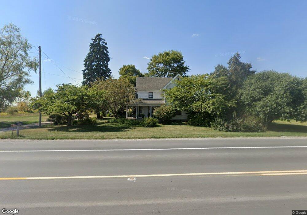
This home is located at 7687 State Route 109, Delta, OH 43515 and is currently estimated at $190,413, approximately $115 per square foot. 7687 State Route 109 is a home located in Fulton County with nearby schools including Delta Elementary School, Pike-Delta-York Middle School, and Pike-Delta-York High School.
Ownership History
Date
Name
Owned For
Owner Type
Purchase Details
Closed on
Mar 3, 2009
Sold by
Estate Of Bruce A Stelter
Bought by
Stelter Brenda A
Current Estimated Value
Purchase Details
Closed on
Jun 12, 1995
Sold by
Trst Izetta H Taylor
Bought by
Stelter Bruce A and Stelter Brenda A
Home Financials for this Owner
Home Financials are based on the most recent Mortgage that was taken out on this home.
Original Mortgage
$52,250
Interest Rate
8.26%
Mortgage Type
New Conventional
Purchase Details
Closed on
Jan 1, 1990
Bought by
Stelter Bruce A
Create a Home Valuation Report for This Property
The Home Valuation Report is an in-depth analysis detailing your home's value as well as a comparison with similar homes in the area
Home Values in the Area
Average Home Value in this Area
Purchase History
| Date | Buyer | Sale Price | Title Company |
|---|---|---|---|
| Stelter Brenda A | -- | None Available | |
| Stelter Bruce A | $55,000 | -- | |
| Stelter Bruce A | -- | -- |
Source: Public Records
Mortgage History
| Date | Status | Borrower | Loan Amount |
|---|---|---|---|
| Previous Owner | Stelter Bruce A | $52,250 |
Source: Public Records
Tax History Compared to Growth
Tax History
| Year | Tax Paid | Tax Assessment Tax Assessment Total Assessment is a certain percentage of the fair market value that is determined by local assessors to be the total taxable value of land and additions on the property. | Land | Improvement |
|---|---|---|---|---|
| 2024 | $1,937 | $50,020 | $9,240 | $40,780 |
| 2023 | $1,938 | $50,020 | $9,240 | $40,780 |
| 2022 | $2,169 | $40,320 | $7,700 | $32,620 |
| 2021 | $2,210 | $40,320 | $7,700 | $32,620 |
| 2020 | $2,198 | $40,320 | $7,700 | $32,620 |
| 2019 | $1,947 | $36,860 | $7,560 | $29,300 |
| 2018 | $1,900 | $36,860 | $7,560 | $29,300 |
| 2017 | $1,877 | $36,860 | $7,560 | $29,300 |
| 2016 | $1,848 | $34,200 | $7,560 | $26,640 |
| 2015 | $1,789 | $34,200 | $7,560 | $26,640 |
| 2014 | $1,788 | $34,200 | $7,560 | $26,640 |
| 2013 | $1,888 | $33,950 | $8,330 | $25,620 |
Source: Public Records
Map
Nearby Homes
- 452 Monroe St
- 434 Monroe St
- 308 Monroe St
- 500 Sandalwood Ln
- 9163 County Road F
- 413 Fernwood St
- 421 Providence St
- 305 Mckinley St
- 600 Fernwood St
- 703 Linwood Ave
- 701 Palmwood St
- 518 Providence St
- 929 Linwood Ave
- 11 Meadow Lane Dr
- 7620 County Road 12
- 7373 County Road 12
- 11715 County Road L
- 0 County Road H
- 13242 Us Highway 20a
- 13354 U S 20a
- 7491 State Route 109
- 7452 State Route 109
- 7424 State Route 109
- 9111 County Road H
- 9130 Co Rd H-J
- 9128 County Road H
- 8778 County Road H
- 8695 County Road H
- 8601 County Road H
- 7167 State Route 109
- 8555 County Road H
- 7129 State Route 109
- 9601 County Road H
- 8900 Us Highway 20a
- 9636 County Road H
- 5618 Airport Hwy
- 9673 County Road H
- 0 St Rt 109
- 9710 County Road H
- 8306 County Road H