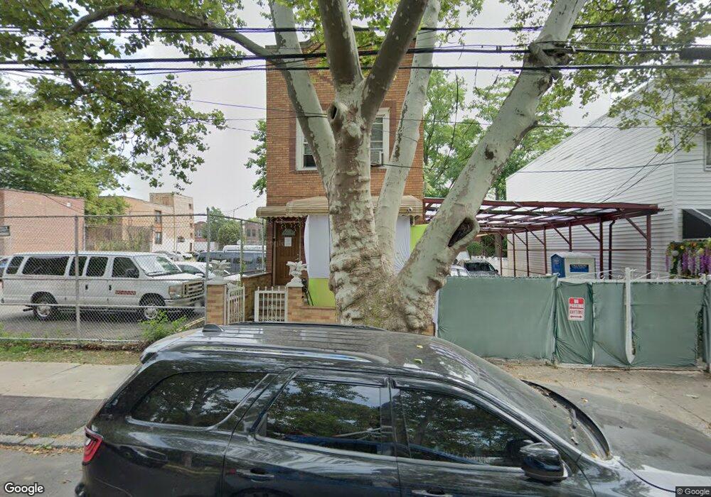
769 Linwood St Brooklyn, NY 11208
East New York NeighborhoodEstimated Value: $577,974 - $963,000
--
Bed
--
Bath
1,752
Sq Ft
$467/Sq Ft
Est. Value
About This Home
This home is located at 769 Linwood St, Brooklyn, NY 11208 and is currently estimated at $817,994, approximately $466 per square foot. 769 Linwood St is a home located in Kings County with nearby schools including P.S. 202 Ernest S Jenkyns, Van Siclen Community Middle School, and Achievement First Aspire Charter.
Ownership History
Date
Name
Owned For
Owner Type
Purchase Details
Closed on
Jun 2, 2003
Sold by
Maloney Sheron and Maloney Yvette
Bought by
Joslyn Eron and Maloney Sheron
Current Estimated Value
Purchase Details
Closed on
May 28, 2002
Sold by
Maloney Sheron
Bought by
Maloney Sheron and Maloney Yvette
Home Financials for this Owner
Home Financials are based on the most recent Mortgage that was taken out on this home.
Original Mortgage
$179,350
Interest Rate
6.64%
Mortgage Type
Purchase Money Mortgage
Create a Home Valuation Report for This Property
The Home Valuation Report is an in-depth analysis detailing your home's value as well as a comparison with similar homes in the area
Home Values in the Area
Average Home Value in this Area
Purchase History
| Date | Buyer | Sale Price | Title Company |
|---|---|---|---|
| Joslyn Eron | -- | -- | |
| Joslyn Eron | -- | -- | |
| Maloney Sheron | -- | -- | |
| Maloney Sheron | -- | -- |
Source: Public Records
Mortgage History
| Date | Status | Borrower | Loan Amount |
|---|---|---|---|
| Previous Owner | Maloney Sheron | $179,350 |
Source: Public Records
Tax History Compared to Growth
Tax History
| Year | Tax Paid | Tax Assessment Tax Assessment Total Assessment is a certain percentage of the fair market value that is determined by local assessors to be the total taxable value of land and additions on the property. | Land | Improvement |
|---|---|---|---|---|
| 2025 | $2,447 | $39,900 | $10,080 | $29,820 |
| 2024 | $2,447 | $46,920 | $10,080 | $36,840 |
| 2023 | $2,336 | $53,940 | $10,080 | $43,860 |
| 2022 | $2,167 | $43,200 | $10,080 | $33,120 |
| 2021 | $2,156 | $33,360 | $10,080 | $23,280 |
| 2020 | $1,071 | $35,700 | $10,080 | $25,620 |
| 2019 | $2,124 | $35,700 | $10,080 | $25,620 |
| 2018 | $1,953 | $9,583 | $2,512 | $7,071 |
| 2017 | $1,844 | $9,045 | $2,917 | $6,128 |
| 2016 | $1,706 | $8,536 | $3,222 | $5,314 |
| 2015 | $809 | $8,533 | $3,032 | $5,501 |
| 2014 | $809 | $8,460 | $3,371 | $5,089 |
Source: Public Records
Map
Nearby Homes
- 791 Linwood St
- 685 Essex St
- 738 Shepherd Ave
- 710 Shepherd Ave
- 956 Hegeman Ave
- 823 New Lots Ave
- 730 Linwood St
- 705 Ashford St
- 477 Berriman St
- 459 Berriman St
- 633 Essex St
- 613 Elton St
- 716 New Lots Ave
- 750 Warwick St
- 369 Berriman St
- 938 Dumont Ave
- 662 Warwick St Unit 5
- 378 Montauk Ave
- 372 Atkins Ave
- 819 Ashford St
- 773 Linwood St
- 775 Linwood St
- 680 Essex St
- 779 Linwood St
- 759 Linwood St
- 781 Linwood St
- 700 Essex St
- 700 Essex St Unit 1
- 700 Essex St Unit 2
- 702 Essex St
- 783 Linwood St
- 706 Essex St
- 787 Linwood St
- 710 Essex St
- 749 Linwood St
- 789 Linwood St
- 714 Essex St
- 756 Linwood St
- 810-832 New Lots Ave
- 718 Essex St