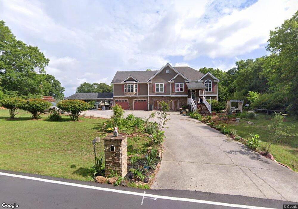
769 Plowshare Rd Carrollton, GA 30117
Estimated Value: $396,000 - $417,000
3
Beds
4
Baths
2,216
Sq Ft
$185/Sq Ft
Est. Value
About This Home
This home is located at 769 Plowshare Rd, Carrollton, GA 30117 and is currently estimated at $410,503, approximately $185 per square foot. 769 Plowshare Rd is a home located in Carroll County with nearby schools including Mt. Zion Elementary School, Mt. Zion Middle School, and Mt. Zion High School.
Ownership History
Date
Name
Owned For
Owner Type
Purchase Details
Closed on
Apr 27, 2001
Sold by
Rancho Const Co
Bought by
Parham Curtis D and Parham Camell
Current Estimated Value
Purchase Details
Closed on
Feb 1, 2000
Sold by
Gary D Poole
Bought by
Ranco Construction C
Create a Home Valuation Report for This Property
The Home Valuation Report is an in-depth analysis detailing your home's value as well as a comparison with similar homes in the area
Home Values in the Area
Average Home Value in this Area
Purchase History
| Date | Buyer | Sale Price | Title Company |
|---|---|---|---|
| Parham Curtis D | $119,000 | -- | |
| Rancho Const Co | -- | -- | |
| Ranco Construction C | $67,800 | -- |
Source: Public Records
Tax History Compared to Growth
Tax History
| Year | Tax Paid | Tax Assessment Tax Assessment Total Assessment is a certain percentage of the fair market value that is determined by local assessors to be the total taxable value of land and additions on the property. | Land | Improvement |
|---|---|---|---|---|
| 2024 | $3,277 | $178,418 | $8,000 | $170,418 |
| 2023 | $3,308 | $163,026 | $8,000 | $155,026 |
| 2022 | $2,775 | $132,582 | $8,000 | $124,582 |
| 2021 | $2,460 | $111,259 | $8,000 | $103,259 |
| 2020 | $2,241 | $99,013 | $8,000 | $91,013 |
| 2019 | $2,148 | $92,986 | $8,000 | $84,986 |
| 2018 | $2,050 | $86,085 | $6,000 | $80,085 |
| 2017 | $2,055 | $86,085 | $6,000 | $80,085 |
| 2016 | $2,142 | $90,885 | $11,200 | $79,685 |
| 2015 | $1,938 | $73,282 | $8,000 | $65,283 |
| 2014 | $1,946 | $73,283 | $8,000 | $65,283 |
Source: Public Records
Map
Nearby Homes
- 113 Richmond Dr
- 442 Plowshare Rd
- 113 Natures Pointe Trail
- 304 Kodiak Rd
- The Joey Plan at Hidden Hills
- The Daniel Plan at Hidden Hills
- 50 Green Acres Dr
- 1202 Mount Zion Rd
- 000 Beulah Church Rd
- 132 Pinnacle Way
- 77 Little River Rd
- 190 Marvin Gray Rd
- 2464 N 27 Highway & Bagwell Rd
- 0 Skinner Rd
- 1423 Beulah Church Rd
- 0 Beulah Church Rd Unit 10366052
- 2994 Mount Zion Rd
- 2994 Mount Zion Rd Unit 1
- 2994 Mount Zion Rd Unit 3
- 101 Virginia Trail
- 765 Plowshare Rd
- 105 Virginia Trail
- 109 Virginia Trail
- 100 Virginia Trail
- 100 Virginia Trail
- 100 Virginia Trail
- 113 Virginia Trail
- 104 Virginia Trail
- 108 Virginia Trail
- 117 Virginia Trail
- 112 Virginia Trail
- 121 Virginia Trail
- 116 Virginia Trail Unit 3
- 116 Virginia Trail
- 101 Richmond Dr
- 125 Virginia Trail
- 107 Richmond Dr
- 120 Virginia Trail
- 131 Richmond Dr