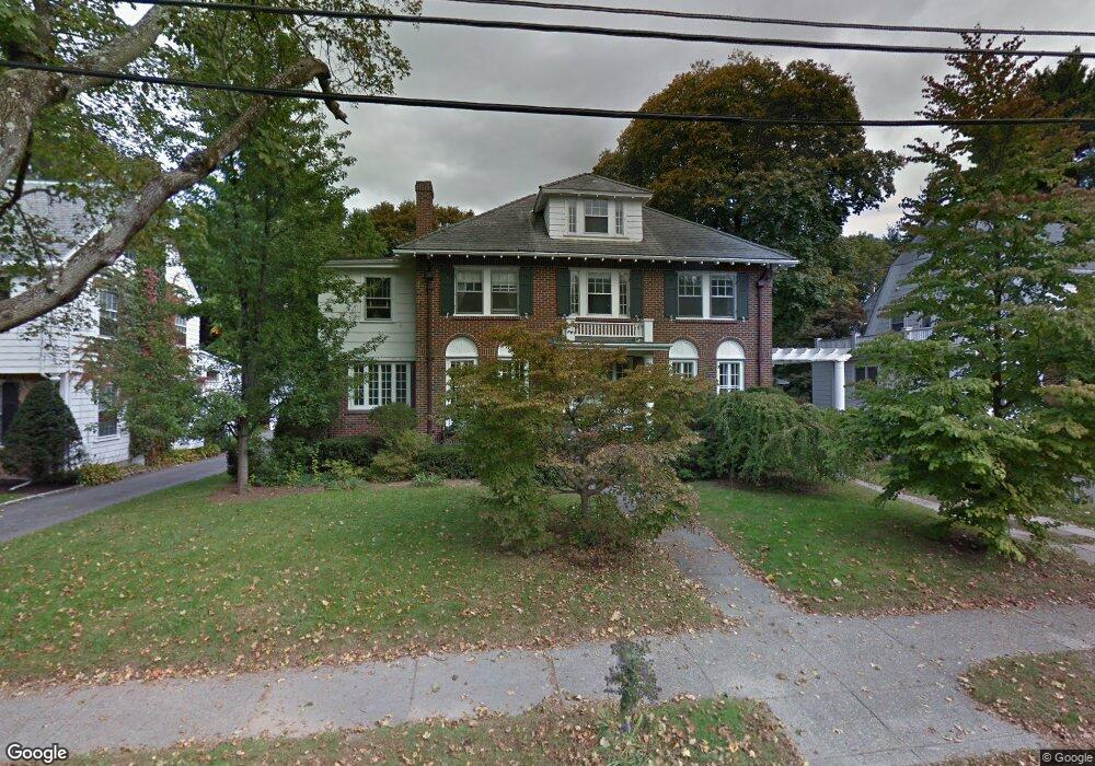
77 Allerton Rd Newton Center, MA 02459
Thompsonville NeighborhoodEstimated Value: $1,947,000 - $2,033,000
4
Beds
4
Baths
2,371
Sq Ft
$834/Sq Ft
Est. Value
About This Home
This home is located at 77 Allerton Rd, Newton Center, MA 02459 and is currently estimated at $1,977,363, approximately $833 per square foot. 77 Allerton Rd is a home located in Middlesex County with nearby schools including Bowen School, Oak Hill Middle School, and Newton South High School.
Ownership History
Date
Name
Owned For
Owner Type
Purchase Details
Closed on
May 26, 1995
Sold by
Est Tenbroeck Lorraine and Newbury Nathan
Bought by
Matveychuk Mary A and Matveychuk Wasly M
Current Estimated Value
Home Financials for this Owner
Home Financials are based on the most recent Mortgage that was taken out on this home.
Original Mortgage
$203,000
Interest Rate
8.33%
Mortgage Type
Purchase Money Mortgage
Create a Home Valuation Report for This Property
The Home Valuation Report is an in-depth analysis detailing your home's value as well as a comparison with similar homes in the area
Home Values in the Area
Average Home Value in this Area
Purchase History
| Date | Buyer | Sale Price | Title Company |
|---|---|---|---|
| Matveychuk Mary A | $455,000 | -- |
Source: Public Records
Mortgage History
| Date | Status | Borrower | Loan Amount |
|---|---|---|---|
| Open | Matveychuk Mary A | $150,000 | |
| Closed | Matveychuk Mary A | $65,000 | |
| Closed | Matveychuk Mary A | $201,000 | |
| Closed | Matveychuk Mary A | $203,000 |
Source: Public Records
Tax History Compared to Growth
Tax History
| Year | Tax Paid | Tax Assessment Tax Assessment Total Assessment is a certain percentage of the fair market value that is determined by local assessors to be the total taxable value of land and additions on the property. | Land | Improvement |
|---|---|---|---|---|
| 2025 | $16,293 | $1,662,600 | $1,100,500 | $562,100 |
| 2024 | $15,755 | $1,614,200 | $1,068,400 | $545,800 |
| 2023 | $14,914 | $1,465,000 | $828,700 | $636,300 |
| 2022 | $14,270 | $1,356,500 | $767,300 | $589,200 |
| 2021 | $13,770 | $1,279,700 | $723,900 | $555,800 |
| 2020 | $5,925 | $1,279,700 | $723,900 | $555,800 |
| 2019 | $5,840 | $1,242,400 | $702,800 | $539,600 |
| 2018 | $5,378 | $1,130,900 | $629,700 | $501,200 |
| 2017 | $11,864 | $1,066,900 | $594,100 | $472,800 |
| 2016 | $11,347 | $997,100 | $555,200 | $441,900 |
| 2015 | $10,819 | $931,900 | $518,900 | $413,000 |
Source: Public Records
Map
Nearby Homes
- 5 Halcyon Rd
- 1597 Centre St Unit 1597
- 1597 Centre St
- 42 Sunhill Ln
- 671 Boylston St
- 625 Boylston St
- 1623-1625 Centre St
- 1629 Centre St
- 125 Oakdale Rd
- 628 Boylston St
- 9 Ripley St Unit 1
- 1151 Walnut St Unit 205
- 1151 Walnut St Unit 405
- 1151 Walnut St Unit 207
- 956 Walnut St Unit 4
- 956 Walnut St Unit 7
- 956 Walnut St Unit 6
- 1292 Walnut St
- 42 Bow Rd
- 1308 Walnut St