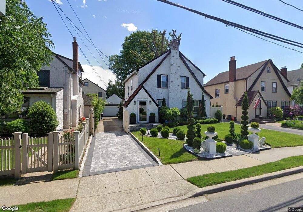
77 Argyle Rd West Hempstead, NY 11552
Estimated Value: $836,818 - $837,000
3
Beds
2
Baths
1,912
Sq Ft
$438/Sq Ft
Est. Value
About This Home
This home is located at 77 Argyle Rd, West Hempstead, NY 11552 and is currently estimated at $836,909, approximately $437 per square foot. 77 Argyle Rd is a home located in Nassau County with nearby schools including Chestnut Street School, West Hempstead Middle School, and West Hempstead Secondary School.
Ownership History
Date
Name
Owned For
Owner Type
Purchase Details
Closed on
Dec 22, 2016
Sold by
Guimaraes Robert and Guimaraes Marcela
Bought by
Petrou Andreas and Cabrera Kirby R
Current Estimated Value
Home Financials for this Owner
Home Financials are based on the most recent Mortgage that was taken out on this home.
Original Mortgage
$295,000
Outstanding Balance
$241,881
Interest Rate
4.03%
Mortgage Type
New Conventional
Estimated Equity
$595,028
Purchase Details
Closed on
Jun 16, 1997
Sold by
Disker Dennis
Bought by
Guimaraes Robert
Create a Home Valuation Report for This Property
The Home Valuation Report is an in-depth analysis detailing your home's value as well as a comparison with similar homes in the area
Home Values in the Area
Average Home Value in this Area
Purchase History
| Date | Buyer | Sale Price | Title Company |
|---|---|---|---|
| Petrou Andreas | $445,000 | All Adelphi Abstract Inc | |
| Guimaraes Robert | $180,000 | -- |
Source: Public Records
Mortgage History
| Date | Status | Borrower | Loan Amount |
|---|---|---|---|
| Open | Petrou Andreas | $295,000 |
Source: Public Records
Tax History
| Year | Tax Paid | Tax Assessment Tax Assessment Total Assessment is a certain percentage of the fair market value that is determined by local assessors to be the total taxable value of land and additions on the property. | Land | Improvement |
|---|---|---|---|---|
| 2025 | $13,103 | $505 | $210 | $295 |
| 2024 | $4,202 | $544 | $226 | $318 |
Source: Public Records
Map
Nearby Homes
- 91 Bedell Ave
- 170 Ivy St
- 197 Ivy St
- 159 Avon Place
- 253 William St
- 179 Fairlawn Ave
- 30 Cathedral Ave Unit 6B
- 244 Hamilton Ave
- 22 Mulford Place Unit 2D
- 22 Mulford Place Unit 6C
- 24 Mulford Place Unit 4B
- 271 Ivy St
- 35 Mulford Place
- 14 Parsons Dr
- 24 Parsons Dr
- 523 Cedar St
- 96 New York Ave
- 82 Hilton Ave
- 26 Sycamore St
- 218 Woodlawn Rd
- 61 Stratford Rd
- 81 Argyle Rd
- 60 Marlborough Rd
- 46 Marlborough Rd
- 67 Stratford Rd
- 84 Argyle Rd
- 42 Marlborough Rd
- 62 Stratford Rd
- 43 Stratford Rd
- 46 Stratford Rd
- 73 Stratford Rd
- 68 Marlborough Rd
- 38 Marlborough Rd
- 55 Marlborough Rd
- 63 Argyle Rd
- 66 Stratford Rd
- 37 Stratford Rd
- 2 Chamberlain Rd
- 72 Marlborough Rd
- 34 Marlborough Rd
Your Personal Tour Guide
Ask me questions while you tour the home.