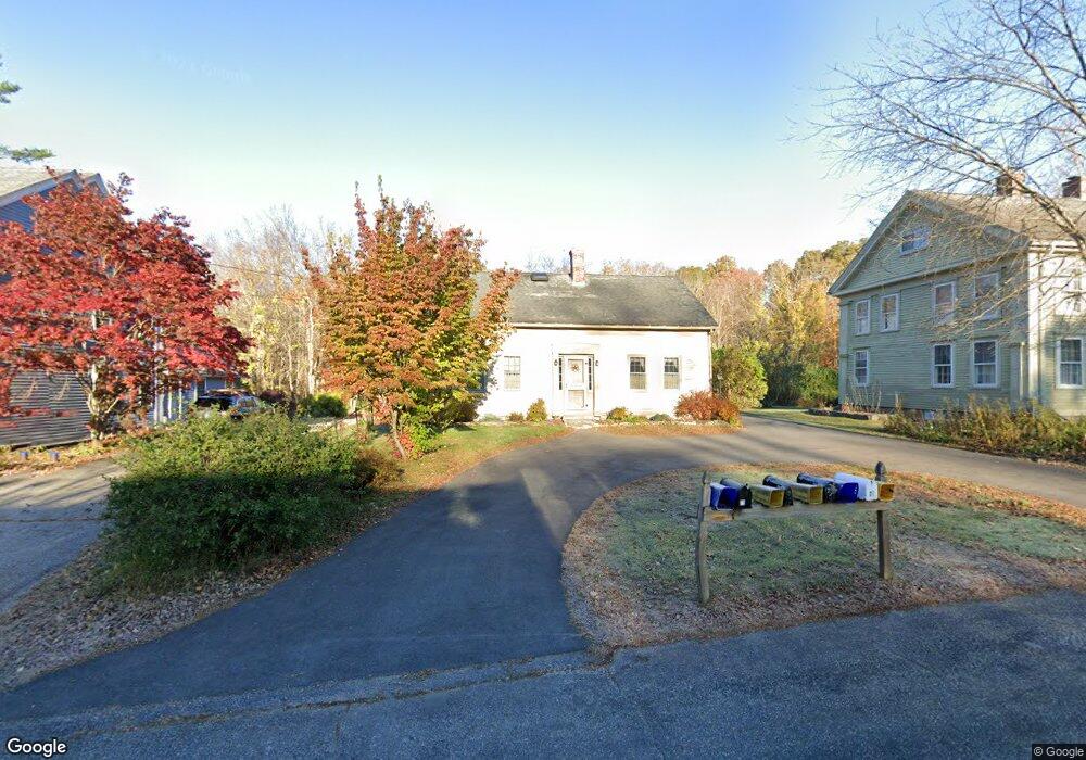
77 Atwoodville Rd Mansfield Center, CT 06250
Estimated Value: $215,000 - $361,000
3
Beds
2
Baths
1,783
Sq Ft
$161/Sq Ft
Est. Value
About This Home
This home is located at 77 Atwoodville Rd, Mansfield Center, CT 06250 and is currently estimated at $286,688, approximately $160 per square foot. 77 Atwoodville Rd is a home located in Tolland County with nearby schools including Mansfield Elementary School, Mansfield Middle School, and E.O. Smith High School.
Ownership History
Date
Name
Owned For
Owner Type
Purchase Details
Closed on
May 9, 2025
Sold by
Pitts Bonnie and Hardegen Karen
Bought by
Crotty Cheryl
Current Estimated Value
Purchase Details
Closed on
May 5, 2025
Sold by
Dyjak Mary E and Crotty Cheryl
Bought by
Crotty Cheryl
Purchase Details
Closed on
Dec 17, 2003
Sold by
Est Boucar Phoebe and Boucar Joseph
Bought by
Dyjak Robert and Dyjak Mary Ellen
Create a Home Valuation Report for This Property
The Home Valuation Report is an in-depth analysis detailing your home's value as well as a comparison with similar homes in the area
Home Values in the Area
Average Home Value in this Area
Purchase History
| Date | Buyer | Sale Price | Title Company |
|---|---|---|---|
| Crotty Cheryl | -- | None Available | |
| Crotty Cheryl | -- | None Available | |
| Crotty Cheryl | -- | None Available | |
| Crotty Cheryl | -- | None Available | |
| Dyjak Robert | $100,000 | -- | |
| Dyjak Robert | $100,000 | -- |
Source: Public Records
Tax History Compared to Growth
Tax History
| Year | Tax Paid | Tax Assessment Tax Assessment Total Assessment is a certain percentage of the fair market value that is determined by local assessors to be the total taxable value of land and additions on the property. | Land | Improvement |
|---|---|---|---|---|
| 2025 | $3,312 | $165,600 | $38,200 | $127,400 |
| 2024 | $3,284 | $107,600 | $35,900 | $71,700 |
| 2023 | $3,392 | $107,600 | $35,900 | $71,700 |
| 2022 | $3,269 | $107,600 | $35,900 | $71,700 |
| 2021 | $3,376 | $107,600 | $35,900 | $71,700 |
| 2020 | $3,376 | $107,600 | $35,900 | $71,700 |
| 2019 | $3,323 | $105,900 | $34,000 | $71,900 |
| 2018 | $3,326 | $107,700 | $35,800 | $71,900 |
| 2017 | $3,299 | $107,700 | $35,800 | $71,900 |
| 2016 | $3,217 | $107,700 | $35,800 | $71,900 |
| 2015 | $3,217 | $107,700 | $35,800 | $71,900 |
| 2014 | $3,522 | $126,000 | $43,820 | $82,180 |
Source: Public Records
Map
Nearby Homes
- 368 Warrenville Rd
- 69 N Bedlam Rd
- 241 Wormwood Hill Rd
- 67 Mulberry Rd
- 140 Federal Rd
- 283 Tower Hill Rd
- 412 Storrs Rd
- 408 Storrs Rd
- 0 Hampton Rd Unit 170523717
- 144 Phoenixville Rd
- 934 Storrs Rd
- 60 Chaplin St
- 80 Lynch Rd
- 985 Storrs Rd
- 85 England Rd
- 124 Spring Hill Rd
- 685 Wormwood Hill Rd
- 287 S Bear Hill Rd
- 17 Jacqueline Ln
- 29 Stone Gate Dr
- 79 Atwoodville Rd
- 75 Atwoodville Rd
- 78 Atwoodville Rd
- 83 Atwoodville Rd
- 88 Atwoodville Rd
- 96 Atwoodville Rd
- 51 Atwoodville Rd
- 41 Atwoodville Rd
- 108 Atwoodville Rd
- 33 Atwoodville Rd
- 9 Atwoodville Ln
- 114 Atwoodville Rd
- 19 Atwoodville Ln
- 122 Atwoodville Rd
- 378 Warrenville Rd
- 384 Warrenville Rd
- 135 Atwoodville Rd
- 362 Warrenville Rd
- 146 Atwoodville Rd
- 400 Warrenville Rd