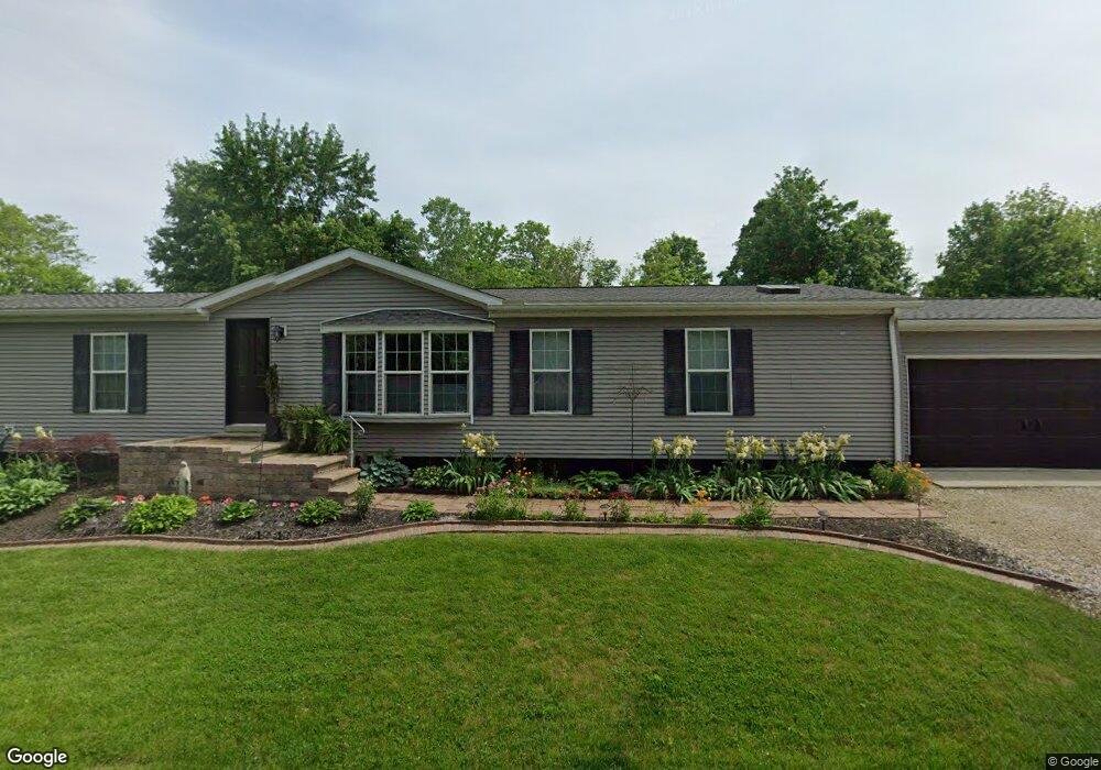
77 E Mohawk Dr Powell, OH 43065
Concord NeighborhoodEstimated Value: $364,000 - $464,000
About This Home
This home is located at 77 E Mohawk Dr, Powell, OH 43065 and is currently estimated at $414,873, approximately $225 per square foot. 77 E Mohawk Dr is a home located in Delaware County with nearby schools including Eli Pinney Elementary School, Willard Grizzell Middle School, and Dublin Jerome High School.
Ownership History
We collect this data history from publicly available records. To have your information removed, we recommend requesting removal directly through your county’s website.
Purchase Details
Home Financials for this Owner
Home Financials are based on the most recent Mortgage that was taken out on this home.Purchase Details
Home Financials for this Owner
Home Financials are based on the most recent Mortgage that was taken out on this home.Purchase Details
Home Financials for this Owner
Home Financials are based on the most recent Mortgage that was taken out on this home.Home Values in the Area
Average Home Value in this Area
Purchase History
We collect this data history from publicly available records. To have your information removed, we recommend requesting removal directly through your county’s website.
| Date | Buyer | Sale Price | Title Company |
|---|---|---|---|
| $120,000 | Northwest Title | ||
| $94,200 | Attorney | ||
| $33,000 | Lawyers Title Agency Of Dela |
Mortgage History
We collect this data history from publicly available records. To have your information removed, we recommend requesting removal directly through your county’s website.
| Date | Status | Borrower | Loan Amount |
|---|---|---|---|
| Open | $40,000 | ||
| Open | $151,353 | ||
| Closed | $116,958 | ||
| Previous Owner | $215,687 | ||
| Previous Owner | $15,057 | ||
| Previous Owner | $165,113 |
Tax History
We collect this data history from publicly available records. To have your information removed, we recommend requesting removal directly through your county’s website.
| Year | Tax Paid | Tax Assessment Tax Assessment Total Assessment is a certain percentage of the fair market value that is determined by local assessors to be the total taxable value of land and additions on the property. | Land | Improvement |
|---|---|---|---|---|
| 2025 | $5,612 | $96,920 | $31,500 | $65,420 |
| 2024 | $5,678 | $96,920 | $31,500 | $65,420 |
| 2023 | $5,647 | $96,920 | $31,500 | $65,420 |
| 2022 | $4,115 | $65,280 | $23,700 | $41,580 |
| 2021 | $4,182 | $65,280 | $23,700 | $41,580 |
| 2020 | $4,195 | $65,280 | $23,700 | $41,580 |
| 2019 | $3,737 | $53,270 | $19,740 | $33,530 |
| 2018 | $3,771 | $53,270 | $19,740 | $33,530 |
| 2017 | $3,186 | $43,540 | $16,380 | $27,160 |
| 2016 | $2,970 | $43,540 | $16,380 | $27,160 |
| 2015 | $2,956 | $43,540 | $16,380 | $27,160 |
| 2014 | $2,988 | $43,540 | $16,380 | $27,160 |
| 2013 | $2,945 | $42,000 | $16,380 | $25,620 |
Map
- 9501 Shawnee Trail
- 0 Shawnee Trail Unit Lots 3359-3360 & 346
- 0 E Wilma Dr Unit Lots 3412-3414 & 343
- 0 E Eileen Dr Unit Lots 3462-3466
- 0 E Eileen Dr Unit Lots 3457-3461
- 9200 Shawnee Trail
- 6375 W Mohican Dr
- 0 N Park Place W Unit 225035823
- 9336 Muirkirk Dr
- 5650 Loch Broom Cir
- 5336 Aryshire Dr
- 5647 Loch Broom Cir
- 5341 Aryshire Dr
- 6761 Colt Ct
- 6637 Brodie Blvd
- 5363 Rosalind Blvd
- 6530 Brodie Blvd
- 9124 Preswick Ct
- 8455 Dunsinane Dr
- 5617 Preswick Dr
- 63 E Mohawk Dr
- 105 E Mohawk Dr
- 77 E Pawnee Dr
- 92 E Cherokee Dr
- 59 E Mohawk Dr
- 95 E Pawnee Dr
- 86 E Cherokee Dr
- 0 E Pawnee Dr
- 134 E Pawnee Dr
- 59 E Pawnee Dr
- 68 E Cherokee Dr
- 95 E Riverview Dr
- 55 E Pawnee Dr
- 123 E Mohawk Dr
- 0 E Cherokee Dr
- 100 E Pawnee Dr
- 85 E Cherokee Dr
- 49 E Pawnee Dr
- 46 E Cherokee Dr
- 40 E Mohawk Dr
Ask me questions while you tour the home.