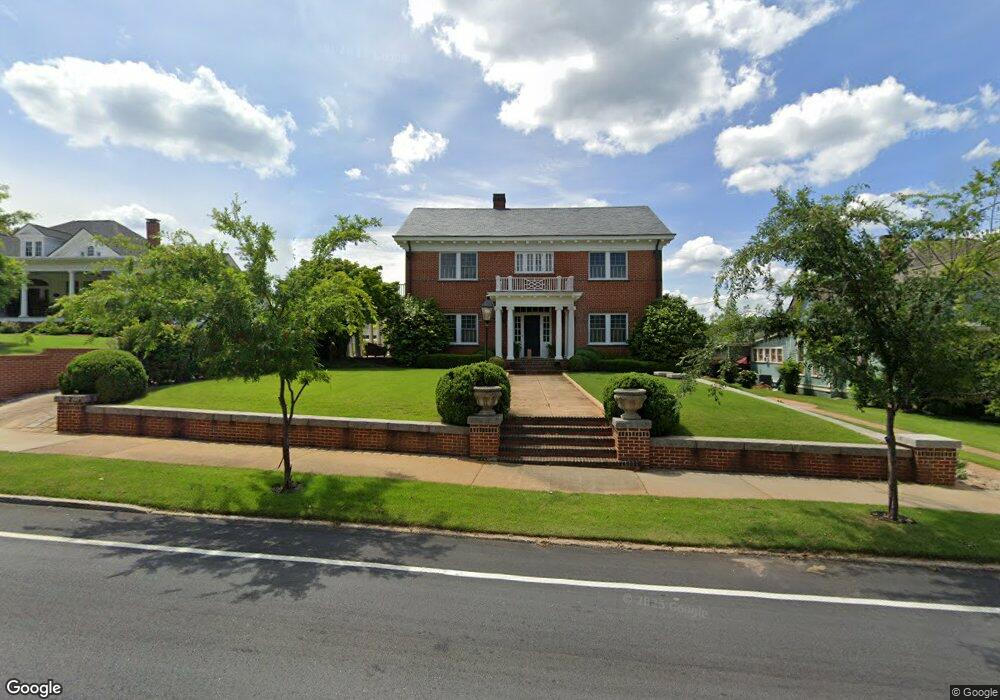
77 Lagrange St Newnan, GA 30263
Estimated Value: $646,000 - $808,000
4
Beds
3
Baths
3,487
Sq Ft
$205/Sq Ft
Est. Value
About This Home
This home is located at 77 Lagrange St, Newnan, GA 30263 and is currently estimated at $713,138, approximately $204 per square foot. 77 Lagrange St is a home located in Coweta County with nearby schools including Atkinson Elementary School, Smokey Road Middle School, and Newnan High School.
Ownership History
Date
Name
Owned For
Owner Type
Purchase Details
Closed on
Sep 20, 2018
Sold by
Jones Walter Eugene
Bought by
Collins Robert C and Collins Lee M
Current Estimated Value
Purchase Details
Closed on
Oct 13, 2011
Sold by
Parker Kenneth A
Bought by
Jones Walter Eugene and Jones Laura Gibson
Home Financials for this Owner
Home Financials are based on the most recent Mortgage that was taken out on this home.
Original Mortgage
$408,500
Interest Rate
4.16%
Mortgage Type
New Conventional
Purchase Details
Closed on
Jan 10, 2005
Sold by
Cole Edith M
Bought by
Parker Kenneth A and Parker Dianne
Home Financials for this Owner
Home Financials are based on the most recent Mortgage that was taken out on this home.
Original Mortgage
$223,284
Interest Rate
5.71%
Mortgage Type
New Conventional
Create a Home Valuation Report for This Property
The Home Valuation Report is an in-depth analysis detailing your home's value as well as a comparison with similar homes in the area
Home Values in the Area
Average Home Value in this Area
Purchase History
| Date | Buyer | Sale Price | Title Company |
|---|---|---|---|
| Collins Robert C | $530,000 | -- | |
| Jones Walter Eugene | $430,000 | -- | |
| Parker Kenneth A | $279,200 | -- |
Source: Public Records
Mortgage History
| Date | Status | Borrower | Loan Amount |
|---|---|---|---|
| Previous Owner | Jones Walter Eugene | $408,500 | |
| Previous Owner | Parker Kenneth A | $223,284 |
Source: Public Records
Tax History Compared to Growth
Tax History
| Year | Tax Paid | Tax Assessment Tax Assessment Total Assessment is a certain percentage of the fair market value that is determined by local assessors to be the total taxable value of land and additions on the property. | Land | Improvement |
|---|---|---|---|---|
| 2025 | $6,514 | $279,002 | $40,000 | $239,002 |
| 2024 | $6,049 | $268,131 | $40,000 | $228,131 |
| 2023 | $6,049 | $224,371 | $38,000 | $186,371 |
| 2022 | $5,292 | $221,011 | $38,000 | $183,011 |
| 2021 | $4,823 | $183,004 | $38,000 | $145,004 |
| 2020 | $4,930 | $183,004 | $38,000 | $145,004 |
| 2019 | $5,362 | $178,506 | $15,475 | $163,031 |
| 2018 | $4,443 | $150,766 | $15,475 | $135,291 |
| 2017 | $4,229 | $144,324 | $15,475 | $128,849 |
| 2016 | $4,234 | $144,324 | $15,475 | $128,848 |
| 2015 | $3,131 | $107,510 | $15,475 | $92,035 |
| 2014 | $3,203 | $107,510 | $15,475 | $92,035 |
Source: Public Records
Map
Nearby Homes
- 70 Hollis Heights
- 68 Spring St
- 20 Salbide Ave
- 157 Lagrange St
- 51 Robinson St
- 71 Spring St
- 138 Greenville St
- 140 Catalina Ct
- 0 N Highway 29 Unit 20115352
- 131 Woodbine Cir
- 10 Burch Ave
- 13 Standish Ct
- 23 Dewey St
- 12 Conner Dr
- 114 Boone Dr
- 11 Long St
- 8 Richard Allen Dr
- 5 Casey Rd
- 13 Johnson Ave
- 26 Boone Dr