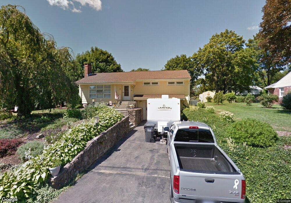
77 Margarite Rd Middletown, CT 06457
Estimated Value: $353,755 - $390,000
3
Beds
1
Bath
1,192
Sq Ft
$310/Sq Ft
Est. Value
About This Home
This home is located at 77 Margarite Rd, Middletown, CT 06457 and is currently estimated at $368,939, approximately $309 per square foot. 77 Margarite Rd is a home located in Middlesex County with nearby schools including Wesley School, St John Paul II School, and The Independent Day School.
Ownership History
Date
Name
Owned For
Owner Type
Purchase Details
Closed on
Oct 24, 2005
Sold by
Celadon John L
Bought by
Zavodjancik Thomas S and Zavodjancik Barbara E
Current Estimated Value
Home Financials for this Owner
Home Financials are based on the most recent Mortgage that was taken out on this home.
Original Mortgage
$55,000
Interest Rate
5.72%
Purchase Details
Closed on
Feb 21, 2002
Sold by
Tochko Paula A
Bought by
Celadon John L
Home Financials for this Owner
Home Financials are based on the most recent Mortgage that was taken out on this home.
Original Mortgage
$126,300
Interest Rate
5.75%
Purchase Details
Closed on
Jun 20, 1997
Sold by
Snipes Philomena Est
Bought by
Tochko Paul A
Create a Home Valuation Report for This Property
The Home Valuation Report is an in-depth analysis detailing your home's value as well as a comparison with similar homes in the area
Home Values in the Area
Average Home Value in this Area
Purchase History
| Date | Buyer | Sale Price | Title Company |
|---|---|---|---|
| Zavodjancik Thomas S | $271,000 | -- | |
| Celadon John L | $133,000 | -- | |
| Tochko Paul A | $94,000 | -- |
Source: Public Records
Mortgage History
| Date | Status | Borrower | Loan Amount |
|---|---|---|---|
| Open | Tochko Paul A | $56,200 | |
| Closed | Tochko Paul A | $25,000 | |
| Closed | Tochko Paul A | $55,000 | |
| Previous Owner | Tochko Paul A | $126,300 |
Source: Public Records
Tax History Compared to Growth
Tax History
| Year | Tax Paid | Tax Assessment Tax Assessment Total Assessment is a certain percentage of the fair market value that is determined by local assessors to be the total taxable value of land and additions on the property. | Land | Improvement |
|---|---|---|---|---|
| 2025 | $5,819 | $157,220 | $63,360 | $93,860 |
| 2024 | $5,567 | $157,220 | $63,360 | $93,860 |
| 2023 | $5,284 | $157,220 | $63,360 | $93,860 |
| 2022 | $4,686 | $113,590 | $42,250 | $71,340 |
| 2021 | $4,665 | $113,590 | $42,250 | $71,340 |
| 2020 | $5,456 | $113,590 | $42,250 | $71,340 |
| 2019 | $5,365 | $113,590 | $42,250 | $71,340 |
| 2018 | $4,519 | $113,590 | $42,250 | $71,340 |
| 2017 | $5,234 | $114,840 | $48,300 | $66,540 |
| 2016 | $4,353 | $114,840 | $48,300 | $66,540 |
| 2015 | $4,257 | $114,840 | $48,300 | $66,540 |
| 2014 | $4,253 | $114,840 | $48,300 | $66,540 |
Source: Public Records
Map
Nearby Homes
- 0 Arbutus St Unit 24065180
- 347 Farm Hill Rd
- 44 Trailside Crossing
- 77 Lindsey Rd
- 50 Garfield Ave
- Lot 3 Coleman Rd
- 55 Lorelei Cir
- 73 Durant St
- 66 Durant Terrace
- 10 Lorelei Cir
- 498 Pine St
- 58 Durant Terrace
- 154 Front St
- 1 Russell St Unit 15
- 1 Russell St Unit 11
- 4 Hillside Ct
- 56 Bidwell Terrace
- 15 Kent Ct
- 128 Highland Ave
- 37 Front St
- 67 Margarite Rd
- 110 Victoria Heights
- 98 Victoria Heights
- 84 Margarite Rd
- 97 Margarite Rd
- 57 Margarite Rd
- 68 Margarite Rd
- 84 Victoria Heights
- 99 Victoria Heights
- 96 Margarite Rd
- 96 Margarite Rd Unit 1
- 107 Victoria Heights
- 58 Margarite Rd
- 47 Margarite Rd
- 104 Margarite Rd
- 113 Victoria Heights
- 111 Margarite Rd
- 119 Victoria Heights
- 87 Victoria Heights
- 50 Mcdowell Rd