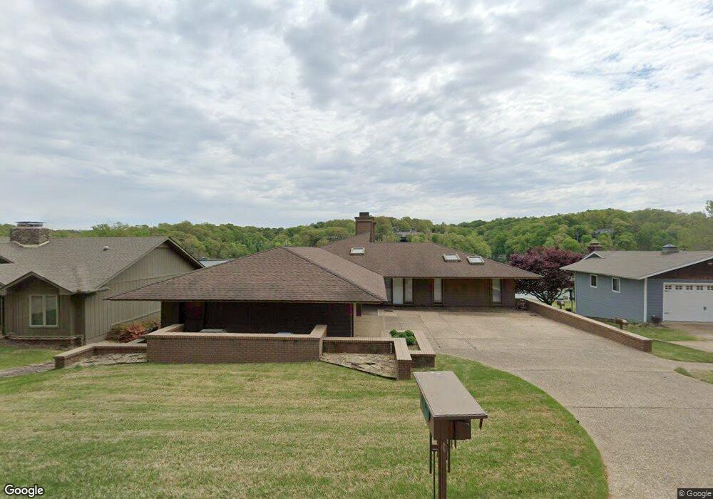
77 Mayfair Dr Bella Vista, AR 72715
Estimated Value: $427,000 - $931,867
--
Bed
4
Baths
2,257
Sq Ft
$330/Sq Ft
Est. Value
About This Home
This home is located at 77 Mayfair Dr, Bella Vista, AR 72715 and is currently estimated at $744,622, approximately $329 per square foot. 77 Mayfair Dr is a home located in Benton County with nearby schools including Cooper Elementary School, Old High Middle School, and Washington Junior High School.
Ownership History
Date
Name
Owned For
Owner Type
Purchase Details
Closed on
Jan 28, 2022
Sold by
Drum David V
Bought by
City Of Bella Vista
Current Estimated Value
Purchase Details
Closed on
Jan 1, 2021
Sold by
John Verner Drum Revocable Trust and Drum David Verner
Bought by
Drum David Verner
Purchase Details
Closed on
Dec 30, 2020
Sold by
Drum David Verner
Bought by
Drum David Verner
Purchase Details
Closed on
Aug 16, 1996
Bought by
Drum Tr
Purchase Details
Closed on
Nov 13, 1995
Bought by
Drum Rev Trust
Purchase Details
Closed on
Oct 28, 1979
Bought by
Drum
Create a Home Valuation Report for This Property
The Home Valuation Report is an in-depth analysis detailing your home's value as well as a comparison with similar homes in the area
Home Values in the Area
Average Home Value in this Area
Purchase History
| Date | Buyer | Sale Price | Title Company |
|---|---|---|---|
| City Of Bella Vista | -- | None Listed On Document | |
| Drum David Verner | -- | None Listed On Document | |
| Drum David Verner | -- | None Available | |
| Drum Tr | -- | -- | |
| Drum Rev Trust | -- | -- | |
| Drum | $25,000 | -- |
Source: Public Records
Tax History Compared to Growth
Tax History
| Year | Tax Paid | Tax Assessment Tax Assessment Total Assessment is a certain percentage of the fair market value that is determined by local assessors to be the total taxable value of land and additions on the property. | Land | Improvement |
|---|---|---|---|---|
| 2025 | $4,741 | $190,636 | $30,000 | $160,636 |
| 2024 | $4,301 | $190,636 | $30,000 | $160,636 |
| 2023 | $3,910 | $102,320 | $15,200 | $87,120 |
| 2022 | $3,699 | $102,320 | $15,200 | $87,120 |
| 2021 | $2,980 | $102,320 | $15,200 | $87,120 |
| 2020 | $3,011 | $74,770 | $13,200 | $61,570 |
| 2019 | $3,011 | $74,770 | $13,200 | $61,570 |
| 2018 | $3,036 | $74,770 | $13,200 | $61,570 |
| 2017 | $2,908 | $74,770 | $13,200 | $61,570 |
| 2016 | $2,908 | $74,770 | $13,200 | $61,570 |
| 2015 | $3,205 | $74,770 | $10,800 | $63,970 |
| 2014 | $2,855 | $74,770 | $10,800 | $63,970 |
Source: Public Records
Map
Nearby Homes
- Lot 14 of Block 4 Heather Cir
- 9 Connie Ln
- 19 Brompton Dr
- 6 Connie Ln
- 6 Neffwood Ln
- Lot 5 Neffwood Ln
- 22 Pembroke Ln
- 21 Estes Dr
- 9 Estes Dr
- 0 Churchill Dr
- 50 Churchill Dr
- 7 Joanie Ln
- 55 Portsmouth Dr
- Lot 26 Block 2 Kensington Dr
- 30 Cromer Dr
- 26 Cromer Dr
- 18 Worstead Ln
- 13 Kensington Dr
- 4 Frensham Ln
- 36 Churchill Dr