W
Seller's Agent in 2025
Weinstein Keach Group
Coldwell Banker Realty - Easton
(508) 230-2544
7 in this area
210 Total Sales

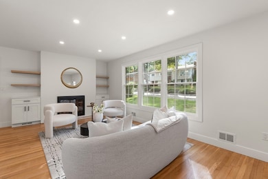
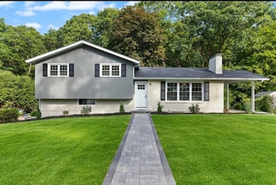
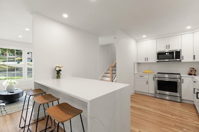
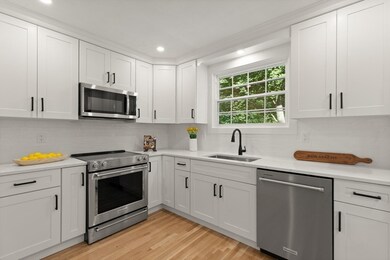
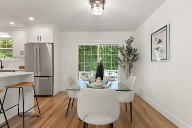
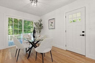
***OFFER ACCEPTED!*** Welcome to your dream home in one of Canton's most desirable neighborhoods, just steps from the Kennedy School. This fully remodeled multi-level residence features 3 bedrooms, 2.5 updated baths, and a stunning kitchen with quartz countertops, new cabinetry, waterfall peninsula seating, and new kitchen stainless steel appliances—plus a brand-new washer and dryer. Recent upgrades include a new energy efficient heat pump, 200-amp electrical panel, wiring, plumbing, roof, windows, doors, lighting and freshly painted inside and out. Bathrooms are beautifully redone with tiled floors and walls, sleek vanities, and modern fixtures. Outside, enjoy a newly landscaped yard, new walkways, a spacious back deck, and a covered side porch. A dedicated office, finished basement bonus room, and new garage door with keypad opener. This home is truly turnkey—offering modern upgrades in a prime location.
Last Agent to Sell the Property
Coldwell Banker Realty - Easton Listed on: 09/03/2025

| Date | Type | Sale Price | Title Company |
|---|---|---|---|
| Deed | $917,000 | -- | |
| Quit Claim Deed | $517,000 | None Available | |
| Personal Reps Deed | -- | None Available | |
| Personal Reps Deed | -- | None Available | |
| Deed | $145,800 | -- | |
| Deed | $145,800 | -- | |
| Leasehold Conv With Agreement Of Sale Fee Purchase Hawaii | $16,200 | -- | |
| Leasehold Conv With Agreement Of Sale Fee Purchase Hawaii | $16,200 | -- |
| Date | Status | Loan Amount | Loan Type |
|---|---|---|---|
| Previous Owner | $576,299 | Purchase Money Mortgage | |
| Previous Owner | $50,000 | Purchase Money Mortgage |
| Date | Event | Price | List to Sale | Price per Sq Ft |
|---|---|---|---|---|
| 10/21/2025 10/21/25 | Sold | $917,000 | +4.8% | $544 / Sq Ft |
| 09/08/2025 09/08/25 | Pending | -- | -- | -- |
| 09/03/2025 09/03/25 | For Sale | $874,900 | -- | $519 / Sq Ft |
| Year | Tax Paid | Tax Assessment Tax Assessment Total Assessment is a certain percentage of the fair market value that is determined by local assessors to be the total taxable value of land and additions on the property. | Land | Improvement |
|---|---|---|---|---|
| 2025 | $5,870 | $593,500 | $324,000 | $269,500 |
| 2024 | $5,588 | $560,500 | $311,600 | $248,900 |
| 2023 | $5,569 | $526,900 | $311,600 | $215,300 |
| 2022 | $5,464 | $481,400 | $296,700 | $184,700 |
| 2021 | $5,359 | $439,300 | $269,700 | $169,600 |
| 2020 | $5,154 | $421,400 | $256,900 | $164,500 |
| 2019 | $5,058 | $407,900 | $233,500 | $174,400 |
| 2018 | $4,872 | $392,300 | $224,500 | $167,800 |
| 2017 | $4,991 | $390,200 | $220,100 | $170,100 |
| 2016 | $4,870 | $380,800 | $214,700 | $166,100 |
| 2015 | $4,788 | $373,500 | $208,500 | $165,000 |
W
Seller's Agent in 2025
Weinstein Keach Group
Coldwell Banker Realty - Easton
(508) 230-2544
7 in this area
210 Total Sales
C
Seller Co-Listing Agent in 2025
Catherine Walsh
Coldwell Banker Realty - Easton
(978) 372-8577
2 in this area
16 Total Sales
Buyer's Agent in 2025
Mary Ellen McDonough
Donahue Real Estate Co.
(781) 223-5813
3 in this area
114 Total Sales
Source: MLS Property Information Network (MLS PIN)
MLS Number: 73425430
APN: CANT-000046-000000-000064
Disclaimer: Certain information contained herein is derived from information provided by parties other than Homes.com. All information provided is deemed reliable, but is not guaranteed to be accurate and should be independently verified.
![]() The property listing data and information, or the Images, set forth herein were provided to MLS Property Information Network, Inc. from third party sources, including sellers, lessors and public records, and were compiled by MLS Property Information Network, Inc. The property listing data and information, and the Images, are for the personal, non-commercial use of consumers having a good faith interest in purchasing or leasing listed properties of the type displayed to them and may not be used for any purpose other than to identify prospective properties which such consumers may have a good faith interest in purchasing or leasing. MLS Property Information Network, Inc. and its subscribers disclaim any and all representations and warranties as to the accuracy of the property listing data and information, or as to the accuracy of any of the Images, set forth herein.
The property listing data and information, or the Images, set forth herein were provided to MLS Property Information Network, Inc. from third party sources, including sellers, lessors and public records, and were compiled by MLS Property Information Network, Inc. The property listing data and information, and the Images, are for the personal, non-commercial use of consumers having a good faith interest in purchasing or leasing listed properties of the type displayed to them and may not be used for any purpose other than to identify prospective properties which such consumers may have a good faith interest in purchasing or leasing. MLS Property Information Network, Inc. and its subscribers disclaim any and all representations and warranties as to the accuracy of the property listing data and information, or as to the accuracy of any of the Images, set forth herein.