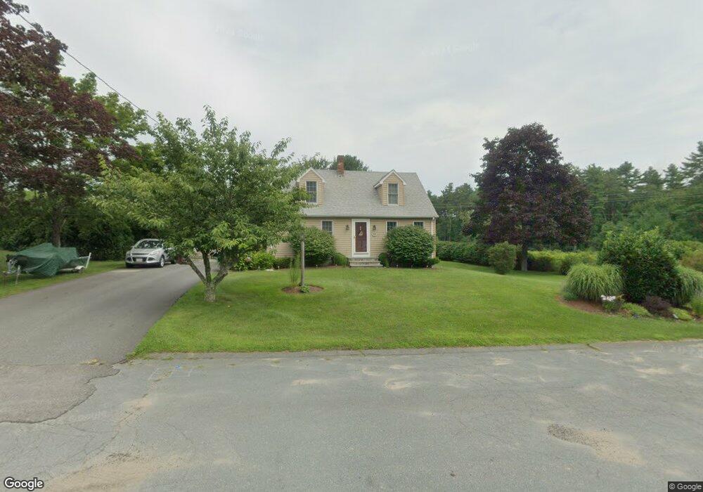
77 Park Dr Acushnet, MA 02743
Sherwood Forest NeighborhoodEstimated Value: $448,000 - $595,000
3
Beds
1
Bath
1,265
Sq Ft
$411/Sq Ft
Est. Value
About This Home
This home is located at 77 Park Dr, Acushnet, MA 02743 and is currently estimated at $520,353, approximately $411 per square foot. 77 Park Dr is a home located in Bristol County with nearby schools including Acushnet Elementary School, Albert F Ford Middle School, and Alma del Mar Charter School.
Ownership History
Date
Name
Owned For
Owner Type
Purchase Details
Closed on
Sep 27, 2021
Sold by
Boucher Rachelle L and Arruda Gloria
Bought by
77 Park Drive Rt and Boucher
Current Estimated Value
Purchase Details
Closed on
May 22, 2006
Sold by
Arruda Gloria and Boucher Rachelle L
Bought by
Arruda Gloria and Boucher Rachelle L
Purchase Details
Closed on
May 28, 2004
Sold by
Arruda Gloria
Bought by
Arruda Gloria and Boucher Rachelle L
Purchase Details
Closed on
Jan 30, 2004
Sold by
Luiz Ann Marie and Luiz Louie J
Bought by
Arruda Gloria
Home Financials for this Owner
Home Financials are based on the most recent Mortgage that was taken out on this home.
Original Mortgage
$235,000
Interest Rate
5.82%
Mortgage Type
Purchase Money Mortgage
Purchase Details
Closed on
Jul 7, 1987
Sold by
Ashley William C
Bought by
Luiz Louis J
Create a Home Valuation Report for This Property
The Home Valuation Report is an in-depth analysis detailing your home's value as well as a comparison with similar homes in the area
Home Values in the Area
Average Home Value in this Area
Purchase History
| Date | Buyer | Sale Price | Title Company |
|---|---|---|---|
| 77 Park Drive Rt | -- | None Available | |
| Arruda Gloria | -- | -- | |
| Arruda Gloria | -- | -- | |
| Arruda Gloria | $296,000 | -- | |
| Luiz Louis J | $146,000 | -- |
Source: Public Records
Mortgage History
| Date | Status | Borrower | Loan Amount |
|---|---|---|---|
| Previous Owner | Luiz Louis J | $235,000 | |
| Previous Owner | Luiz Louis J | $48,000 | |
| Previous Owner | Luiz Louis J | $25,500 |
Source: Public Records
Tax History
| Year | Tax Paid | Tax Assessment Tax Assessment Total Assessment is a certain percentage of the fair market value that is determined by local assessors to be the total taxable value of land and additions on the property. | Land | Improvement |
|---|---|---|---|---|
| 2025 | $40 | $374,800 | $123,700 | $251,100 |
| 2024 | $3,910 | $342,700 | $117,000 | $225,700 |
| 2023 | $3,872 | $322,700 | $101,200 | $221,500 |
| 2022 | $3,816 | $287,600 | $96,700 | $190,900 |
| 2021 | $3,535 | $255,600 | $96,700 | $158,900 |
| 2020 | $3,563 | $255,600 | $96,700 | $158,900 |
| 2019 | $3,511 | $247,600 | $99,000 | $148,600 |
| 2018 | $3,399 | $235,700 | $99,000 | $136,700 |
| 2017 | $3,282 | $227,300 | $99,000 | $128,300 |
| 2016 | $3,237 | $222,800 | $92,200 | $130,600 |
| 2015 | $2,967 | $207,800 | $92,200 | $115,600 |
Source: Public Records
Map
Nearby Homes
- 134 Nyes Ln
- 329 Middle Rd
- 1015 Forbes St
- SS Charbonneau Ln
- 40 Foley Dr
- ES Acushnet Ave
- 765 Pine Hill Dr
- 145 Heritage Dr
- 34 Poplar Rd
- 0 Keene Rd Unit 73459818
- WS Phillips Rd
- ES Phillips Rd
- 7 Hamlin St
- 0 Land Way Unit 73479153
- 1044 Phillips Rd Unit 25
- 1044 Phillips Rd Unit 20
- 898 Tobey St
- 23 Coury Dr
- 2800 Acushnet Ave
- 1251 Church St Unit 10
Your Personal Tour Guide
Ask me questions while you tour the home.