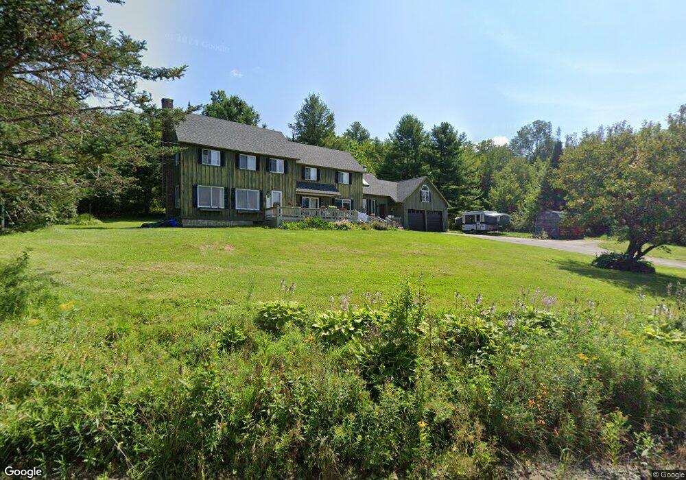
77 Rowell Rd Lancaster, NH 03584
Estimated Value: $416,000 - $494,000
3
Beds
3
Baths
3,000
Sq Ft
$150/Sq Ft
Est. Value
About This Home
This home is located at 77 Rowell Rd, Lancaster, NH 03584 and is currently estimated at $450,098, approximately $150 per square foot. 77 Rowell Rd is a home located in Coos County with nearby schools including Lancaster Elementary School and White Mountains Regional High School.
Ownership History
Date
Name
Owned For
Owner Type
Purchase Details
Closed on
Jun 23, 2010
Sold by
Hopkins 3Rd John Silas and Rooney Donna Lee
Bought by
Temkkit Kader and Northey-Temkkit Nadine F
Current Estimated Value
Home Financials for this Owner
Home Financials are based on the most recent Mortgage that was taken out on this home.
Original Mortgage
$104,000
Outstanding Balance
$68,658
Interest Rate
4.98%
Mortgage Type
Purchase Money Mortgage
Estimated Equity
$381,440
Purchase Details
Closed on
Jun 12, 2002
Sold by
Unknown
Bought by
Hopkins John Silas
Home Financials for this Owner
Home Financials are based on the most recent Mortgage that was taken out on this home.
Original Mortgage
$100,000
Interest Rate
6.8%
Create a Home Valuation Report for This Property
The Home Valuation Report is an in-depth analysis detailing your home's value as well as a comparison with similar homes in the area
Home Values in the Area
Average Home Value in this Area
Purchase History
| Date | Buyer | Sale Price | Title Company |
|---|---|---|---|
| Temkkit Kader | $171,000 | -- | |
| Hopkins John Silas | $180,000 | -- |
Source: Public Records
Mortgage History
| Date | Status | Borrower | Loan Amount |
|---|---|---|---|
| Open | Hopkins John Silas | $104,000 | |
| Previous Owner | Hopkins John Silas | $100,000 |
Source: Public Records
Tax History
| Year | Tax Paid | Tax Assessment Tax Assessment Total Assessment is a certain percentage of the fair market value that is determined by local assessors to be the total taxable value of land and additions on the property. | Land | Improvement |
|---|---|---|---|---|
| 2025 | $6,643 | $315,300 | $64,500 | $250,800 |
| 2024 | $6,047 | $315,300 | $64,500 | $250,800 |
| 2023 | $5,458 | $315,300 | $64,500 | $250,800 |
| 2022 | $4,914 | $202,300 | $38,100 | $164,200 |
| 2021 | $5,298 | $202,300 | $38,100 | $164,200 |
| 2020 | $5,005 | $202,300 | $38,100 | $164,200 |
| 2019 | $5,037 | $202,300 | $38,100 | $164,200 |
| 2018 | $5,292 | $202,300 | $38,100 | $164,200 |
| 2017 | $5,228 | $198,500 | $37,400 | $161,100 |
| 2016 | $5,084 | $198,500 | $37,400 | $161,100 |
| 2015 | $5,457 | $198,500 | $37,400 | $161,100 |
| 2014 | $4,645 | $198,500 | $37,400 | $161,100 |
| 2013 | $4,635 | $198,500 | $37,400 | $161,100 |
Source: Public Records
Map
Nearby Homes
- 98 Rowell Rd
- 53 Pleasant Valley Rd
- Lot 29 Marshall Rd
- 19 Great Rock Rd
- 0 Garland Rd Unit 38
- 86 & 90 Garland Rd
- 435 North Rd
- 3 Chellie Ln
- 36 Longview Dr
- 101 Page Hill Rd
- Lot 12 Page Hill Rd
- 140 Middle St
- Lot 82 Portland St
- Lot 2 Portland St
- 218 Portland St
- Lot 5 Kelsea Ave
- 12 Wolcott St
- 90 Bunker Hill St
- Lot 26 Hartco Ave
- Lot 21 Hartco Ave
- 130 Pleasant Valley Rd
- 154 Pleasant Valley Rd
- 162 Pleasant Valley Rd
- 8 Rowell Rd
- 68 Rowell Rd
- 80 Rowell Rd
- 92 Rowell Rd
- 100 Rowell Rd
- 91 Rowell Rd
- 69 Rowell Rd
- 19 Rowell Rd
- 93 Rowell Rd
- 46 Rowell Rd
- 00 Apple Hill Rd
- Lot 26 Apple Hill
- Lot 26 Apple Hill Rd
- 3 Rowell Rd
- 259 Pleasant Valley Rd
- 0 Rowell Rd Unit 4212581
- 0 Rowell Rd Unit 4714473
Your Personal Tour Guide
Ask me questions while you tour the home.