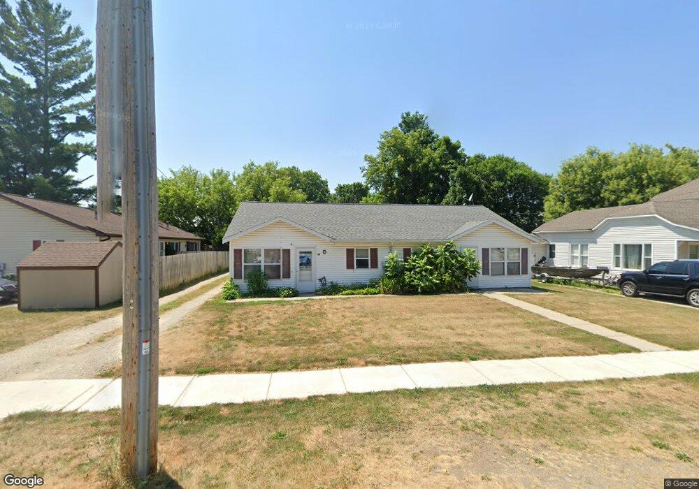
77 S 2nd St Cedar Springs, MI 49319
Estimated Value: $242,000 - $323,000
--
Bed
2
Baths
1,800
Sq Ft
$159/Sq Ft
Est. Value
About This Home
This home is located at 77 S 2nd St, Cedar Springs, MI 49319 and is currently estimated at $287,084, approximately $159 per square foot. 77 S 2nd St is a home located in Kent County with nearby schools including Cedar Trails Elementary School, Red Hawk Intermediate School, and Beach Elementary School.
Ownership History
Date
Name
Owned For
Owner Type
Purchase Details
Closed on
Jan 28, 2010
Sold by
Grifhorst Kevin and Grifhorst Michelle
Bought by
Kevin Grifhorst Properties Llc
Current Estimated Value
Purchase Details
Closed on
May 12, 2009
Sold by
Trott & Trott Pc
Bought by
Grifhorst Kevin
Purchase Details
Closed on
Sep 4, 2008
Sold by
Independent Mortgage Co
Bought by
Federal National Mortgage Association
Purchase Details
Closed on
Aug 20, 2008
Sold by
Lewis David W and Lewis Kelly G
Bought by
Independent Mortgage Co and Independent Mortgage Co West Mi
Purchase Details
Closed on
Mar 18, 2005
Sold by
Lewis David W and Lewis Kelly G
Bought by
Lynx Property Management Llc
Purchase Details
Closed on
Dec 17, 1999
Bought by
Lewis David W and Gifhorst Kevin Properties Llc
Create a Home Valuation Report for This Property
The Home Valuation Report is an in-depth analysis detailing your home's value as well as a comparison with similar homes in the area
Home Values in the Area
Average Home Value in this Area
Purchase History
| Date | Buyer | Sale Price | Title Company |
|---|---|---|---|
| Kevin Grifhorst Properties Llc | -- | None Available | |
| Grifhorst Kevin | $85,000 | Warranty Title Agency Llc | |
| Federal National Mortgage Association | -- | None Available | |
| Independent Mortgage Co | $101,507 | None Available | |
| Lynx Property Management Llc | -- | -- | |
| Lewis David W | $15,000 | -- |
Source: Public Records
Tax History Compared to Growth
Tax History
| Year | Tax Paid | Tax Assessment Tax Assessment Total Assessment is a certain percentage of the fair market value that is determined by local assessors to be the total taxable value of land and additions on the property. | Land | Improvement |
|---|---|---|---|---|
| 2025 | $4,812 | $120,100 | $0 | $0 |
| 2024 | $4,812 | $118,000 | $0 | $0 |
| 2023 | $4,583 | $97,400 | $0 | $0 |
| 2022 | $4,559 | $105,900 | $0 | $0 |
| 2021 | $4,492 | $92,100 | $0 | $0 |
| 2020 | $4,312 | $93,100 | $0 | $0 |
| 2019 | $4,200 | $90,800 | $0 | $0 |
| 2018 | $4,112 | $72,600 | $0 | $0 |
| 2017 | $4,008 | $66,400 | $0 | $0 |
| 2016 | $3,916 | $65,000 | $0 | $0 |
| 2015 | -- | $65,000 | $0 | $0 |
| 2013 | -- | $61,600 | $0 | $0 |
Source: Public Records
Map
Nearby Homes
- 69 S Main
- 71 N 2nd St NE
- 115 E Cherry St NE
- 139 N 5th St NE
- 197 E Elm St
- 260 Pear St NE
- 373 Cedar St NE
- 295 8th St NE
- 249 Maple
- 4398 17 Mile Rd NE
- 281 Ronald St NE
- 322 E Ash St NE
- 224 Ann St NE
- 340 West St
- 369 E Muskegon St
- 520 Needlewood Dr
- 11288 18 Mile Rd NE
- 11260 18 Mile Rd NE
- 490 Pioneer Trail
- 376 Needlewood Dr NE