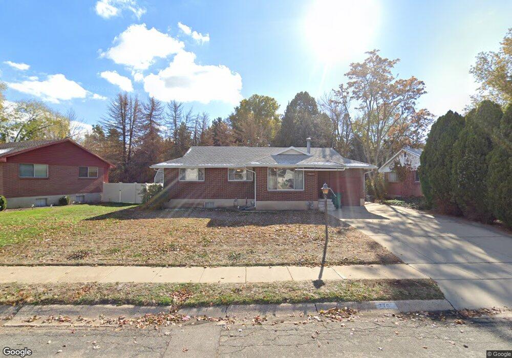
770 Adams St Layton, UT 84041
Estimated Value: $392,000 - $422,000
4
Beds
2
Baths
967
Sq Ft
$422/Sq Ft
Est. Value
About This Home
This home is located at 770 Adams St, Layton, UT 84041 and is currently estimated at $407,798, approximately $421 per square foot. 770 Adams St is a home located in Davis County with nearby schools including Whitesides Elementary School, Central Davis Junior High School, and Layton High School.
Ownership History
Date
Name
Owned For
Owner Type
Purchase Details
Closed on
Oct 27, 2025
Sold by
Ruby Caddie Roberts Revocable Trust and Roberts Blaine L
Bought by
Page James D and Page Alyssa K
Current Estimated Value
Home Financials for this Owner
Home Financials are based on the most recent Mortgage that was taken out on this home.
Original Mortgage
$309,000
Outstanding Balance
$309,000
Interest Rate
6.26%
Mortgage Type
New Conventional
Estimated Equity
$98,798
Purchase Details
Closed on
Aug 12, 2025
Sold by
Roberts Ruby Caddie
Bought by
Ruby Caddie Roberts Revocable Trust and Roberts
Purchase Details
Closed on
Feb 8, 2006
Sold by
Roberts Ruby C
Bought by
Roberts Ruby C
Home Financials for this Owner
Home Financials are based on the most recent Mortgage that was taken out on this home.
Original Mortgage
$93,000
Interest Rate
6.16%
Mortgage Type
New Conventional
Purchase Details
Closed on
Jun 14, 2002
Sold by
Roberts Dean L and Roberts Wilma L
Bought by
Roberts Dean L and Roberts Wilma L
Purchase Details
Closed on
May 22, 2001
Sold by
Roberts Dean L and Roberts Wiliam L
Bought by
Roberts Dean L and Roberts Wiliam L
Purchase Details
Closed on
Sep 14, 2000
Sold by
Roberts Dean L and Roberts Wilma L
Bought by
Roberts Dean L and Roberts Wiliam L
Create a Home Valuation Report for This Property
The Home Valuation Report is an in-depth analysis detailing your home's value as well as a comparison with similar homes in the area
Home Values in the Area
Average Home Value in this Area
Purchase History
| Date | Buyer | Sale Price | Title Company |
|---|---|---|---|
| Page James D | -- | Pinnacle Title | |
| Ruby Caddie Roberts Revocable Trust | -- | None Listed On Document | |
| Roberts Ruby C | -- | Bonneville Title Company | |
| Roberts Dean L | -- | -- | |
| Roberts Dean L | -- | American Preffered Title Llc | |
| Roberts Dean L | -- | -- |
Source: Public Records
Mortgage History
| Date | Status | Borrower | Loan Amount |
|---|---|---|---|
| Open | Page James D | $309,000 | |
| Previous Owner | Roberts Ruby C | $93,000 |
Source: Public Records
Tax History Compared to Growth
Tax History
| Year | Tax Paid | Tax Assessment Tax Assessment Total Assessment is a certain percentage of the fair market value that is determined by local assessors to be the total taxable value of land and additions on the property. | Land | Improvement |
|---|---|---|---|---|
| 2025 | $1,981 | $207,900 | $100,178 | $107,722 |
| 2024 | $1,914 | $202,401 | $116,837 | $85,564 |
| 2023 | $1,797 | $335,000 | $139,920 | $195,080 |
| 2022 | $1,864 | $188,650 | $73,674 | $114,976 |
| 2021 | $1,616 | $244,000 | $102,544 | $141,456 |
| 2020 | $1,464 | $212,000 | $86,619 | $125,381 |
| 2019 | $1,438 | $204,000 | $82,576 | $121,424 |
| 2018 | $1,285 | $183,000 | $82,576 | $100,424 |
| 2016 | $1,104 | $81,126 | $26,164 | $54,962 |
| 2015 | $1,053 | $73,426 | $26,164 | $47,262 |
| 2014 | $1,321 | $94,216 | $26,164 | $68,052 |
| 2013 | -- | $72,563 | $18,612 | $53,951 |
Source: Public Records
Map
Nearby Homes
- 942 E Gentile St
- 86 Mill Rd
- 110 Mill Rd
- 1168 Holmes Creek Ln
- 431 N 1050 E
- 1247 E 300 N
- 508 N Adamswood Rd
- 556 N Fairfield Rd Unit A2
- 556 N Fairfield Rd Unit D1
- 556 N Fairfield Rd Unit D2
- 556 N Fairfield Rd Unit A3
- 556 N Fairfield Rd Unit D3
- 556 N Fairfield Rd Unit D4
- 556 N Fairfield Rd Unit A1
- 556 N Fairfield Rd Unit A4
- 617 E 405 S
- 857 E 575 N
- 861 E 575 N
- 818 Creekside Dr
- 479 N 1375 E