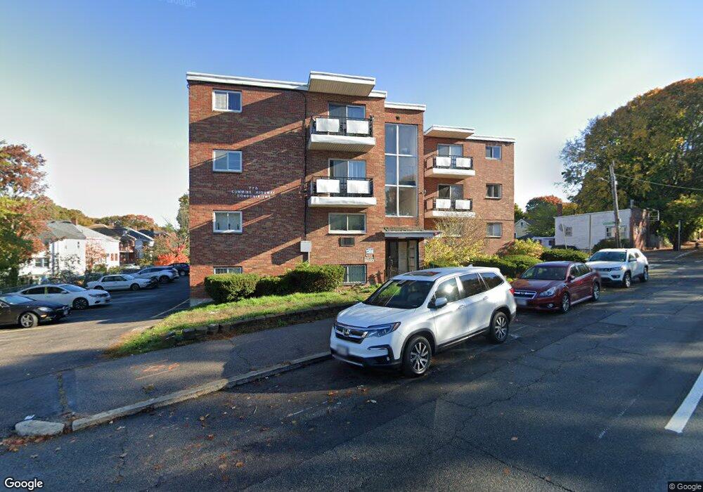
770 Cummins Hwy Unit 18 Mattapan, MA 02126
Southern Mattapan NeighborhoodEstimated Value: $294,288 - $447,000
2
Beds
1
Bath
625
Sq Ft
$543/Sq Ft
Est. Value
About This Home
This home is located at 770 Cummins Hwy Unit 18, Mattapan, MA 02126 and is currently estimated at $339,072, approximately $542 per square foot. 770 Cummins Hwy Unit 18 is a home located in Suffolk County with nearby schools including KIPP Academy Boston Charter School and Berea Seventh-day Adventist Academy.
Ownership History
Date
Name
Owned For
Owner Type
Purchase Details
Closed on
Oct 28, 2008
Sold by
Deutsche Bank Natl T C
Bought by
Moise Georges E and Moise Rose
Current Estimated Value
Purchase Details
Closed on
Sep 5, 2007
Sold by
Allison Evan R and Deutsche Bank Natl T C
Bought by
Deutsche Bank Natl T C
Purchase Details
Closed on
Feb 13, 1995
Sold by
Department Of Housing & Urban Dev
Bought by
Allison Norrisa
Purchase Details
Closed on
Apr 2, 1993
Sold by
Belle Everton and Fleet Mtg Corp
Bought by
Fleet Mtg Corp
Create a Home Valuation Report for This Property
The Home Valuation Report is an in-depth analysis detailing your home's value as well as a comparison with similar homes in the area
Home Values in the Area
Average Home Value in this Area
Purchase History
| Date | Buyer | Sale Price | Title Company |
|---|---|---|---|
| Moise Georges E | $55,000 | -- | |
| Deutsche Bank Natl T C | $123,646 | -- | |
| Allison Norrisa | $15,000 | -- | |
| Allison Norrisa | $15,000 | -- | |
| Fleet Mtg Corp | $71,281 | -- |
Source: Public Records
Tax History Compared to Growth
Tax History
| Year | Tax Paid | Tax Assessment Tax Assessment Total Assessment is a certain percentage of the fair market value that is determined by local assessors to be the total taxable value of land and additions on the property. | Land | Improvement |
|---|---|---|---|---|
| 2025 | $2,850 | $246,100 | $0 | $246,100 |
| 2024 | $2,756 | $252,800 | $0 | $252,800 |
| 2023 | $2,633 | $245,200 | $0 | $245,200 |
| 2022 | $2,494 | $229,200 | $0 | $229,200 |
| 2021 | $2,274 | $213,100 | $0 | $213,100 |
| 2020 | $1,521 | $144,000 | $0 | $144,000 |
| 2019 | $1,381 | $131,000 | $0 | $131,000 |
| 2018 | $1,373 | $131,000 | $0 | $131,000 |
| 2017 | $1,308 | $123,500 | $0 | $123,500 |
| 2016 | $1,319 | $119,900 | $0 | $119,900 |
| 2015 | $1,382 | $114,100 | $0 | $114,100 |
| 2014 | $1,393 | $110,700 | $0 | $110,700 |
Source: Public Records
Map
Nearby Homes
- 770 Cummins Hwy Unit 1
- 770 Cummins Hwy Unit 22
- 10 Brockton St
- 95 Woodhaven St
- 839-843 Cummins Hwy
- 90 Hollingsworth St
- 231 Itasca St
- 48-50 Rockdale St
- 23 Caton St
- 100 Itasca St
- 34 Ridlon Rd
- 20 Monterey Ave
- 1465 Blue Hill Ave
- 60 and 64 Monterey Ave
- 645 River St
- 25 Alpine St Unit 7
- 116 Almont St
- 179 Hebron St
- 72 Livermore St
- 12 Hiawatha Rd
- 770 Cummins Hwy Unit 28
- 770 Cummins Hwy Unit 27
- 770 Cummins Hwy Unit 26
- 770 Cummins Hwy Unit 25
- 770 Cummins Hwy Unit 24
- 770 Cummins Hwy Unit 23
- 770 Cummins Hwy Unit 21
- 770 Cummins Hwy Unit 20
- 770 Cummins Hwy Unit 19
- 770 Cummins Hwy Unit 17
- 770 Cummins Hwy Unit 16
- 770 Cummins Hwy Unit 15
- 770 Cummins Hwy Unit 14
- 770 Cummins Hwy Unit 12A
- 770 Cummins Hwy Unit 11
- 770 Cummins Hwy Unit 10
- 770 Cummins Hwy Unit 9
- 770 Cummins Hwy Unit 8
- 770 Cummins Hwy Unit 7
- 770 Cummins Hwy Unit 6