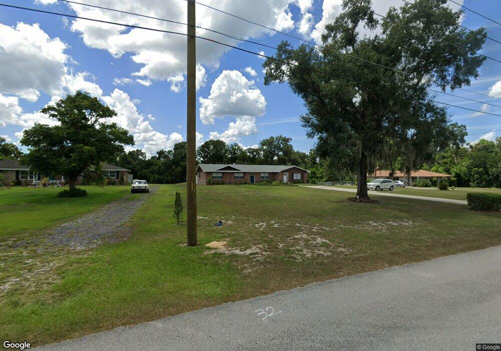
770 N Boundary Ave Deland, FL 32720
Estimated Value: $366,000 - $416,000
3
Beds
2
Baths
1,917
Sq Ft
$205/Sq Ft
Est. Value
About This Home
This home is located at 770 N Boundary Ave, Deland, FL 32720 and is currently estimated at $393,841, approximately $205 per square foot. 770 N Boundary Ave is a home located in Volusia County with nearby schools including Citrus Grove Elementary, Deland High School, and Southwestern Middle School.
Ownership History
Date
Name
Owned For
Owner Type
Purchase Details
Closed on
Feb 5, 2008
Sold by
Parent Paul
Bought by
Parent Paul
Current Estimated Value
Purchase Details
Closed on
Dec 30, 1999
Sold by
Wa Mutual Bk F A
Bought by
Parent Paul and Parent Patricia
Purchase Details
Closed on
Nov 2, 1999
Sold by
Clerk Circuit Court
Bought by
Wa Mutual Bk F A and Home Sav Amer F S B
Purchase Details
Closed on
Dec 15, 1989
Bought by
Parent Paul Tr
Purchase Details
Closed on
Sep 15, 1978
Bought by
Parent Paul Tr
Purchase Details
Closed on
Feb 15, 1974
Bought by
Parent Paul Tr
Create a Home Valuation Report for This Property
The Home Valuation Report is an in-depth analysis detailing your home's value as well as a comparison with similar homes in the area
Home Values in the Area
Average Home Value in this Area
Purchase History
| Date | Buyer | Sale Price | Title Company |
|---|---|---|---|
| Parent Paul | -- | Attorney | |
| Parent Paul | $97,000 | -- | |
| Wa Mutual Bk F A | -- | -- | |
| Parent Paul Tr | $100 | -- | |
| Parent Paul Tr | $38,000 | -- | |
| Parent Paul Tr | $35,400 | -- |
Source: Public Records
Tax History Compared to Growth
Tax History
| Year | Tax Paid | Tax Assessment Tax Assessment Total Assessment is a certain percentage of the fair market value that is determined by local assessors to be the total taxable value of land and additions on the property. | Land | Improvement |
|---|---|---|---|---|
| 2025 | $5,007 | $331,582 | $80,359 | $251,223 |
| 2024 | $5,007 | $335,972 | $80,359 | $255,613 |
| 2023 | $5,007 | $304,912 | $48,000 | $256,912 |
| 2022 | $4,606 | $272,191 | $40,320 | $231,871 |
| 2021 | $4,478 | $243,414 | $40,320 | $203,094 |
| 2020 | $4,084 | $220,859 | $40,320 | $180,539 |
| 2019 | $3,873 | $198,558 | $36,000 | $162,558 |
| 2018 | $3,684 | $182,826 | $28,800 | $154,026 |
| 2017 | $3,439 | $161,466 | $28,800 | $132,666 |
| 2016 | $3,108 | $149,783 | $0 | $0 |
| 2015 | $2,897 | $132,906 | $0 | $0 |
| 2014 | $2,628 | $111,701 | $0 | $0 |
Source: Public Records
Map
Nearby Homes
- 600 N Boundary Ave Unit 119B
- 600 N Boundary Ave Unit 110A
- 600 N Boundary Ave Unit 114-C
- 600 N Boundary Ave Unit 106-D
- 748 W Florence Ave
- Malory Plan at Delaney Reserve
- Abbey Plan at Delaney Reserve
- 710 Florida Elm Ct
- 702 Florida Elm Ct
- 698 Florida Elm Ct
- 694 Florida Elm Ct
- 1133 Red Buckeye Ct
- 1141 Red Buckeye Ct
- 1145 Red Buckeye Ct
- 727 N Stone St
- 600 W Hogle Ave
- 600 Brittle Fern Ave
- 1290 W Plymouth Ave
- 1126 W Minnesota Ave
- 970 N Spring Garden Ave Unit 311
- 760 N Boundary Ave
- 780 N Boundary Ave
- 750 N Boundary Ave
- 765 N Boundary Ave
- 775 N Boundary Ave
- 820 N Boundary Ave
- 740 N Boundary Ave
- 755 N Boundary Ave
- 703 N Boundary Ave
- 702 N Boundary Ave
- 820 W Oakdale Ave
- 824 N Boundary Ave
- 851 W Pennsylvania Ave
- 809 W Hogle Ave
- 825 W Pennsylvania Ave
- 850 W Hogle Ave
- 858 W Plymouth Ave
- 803 W Hogle Ave
- 819 W Pennsylvania Ave
- 635 N Boundary Ave