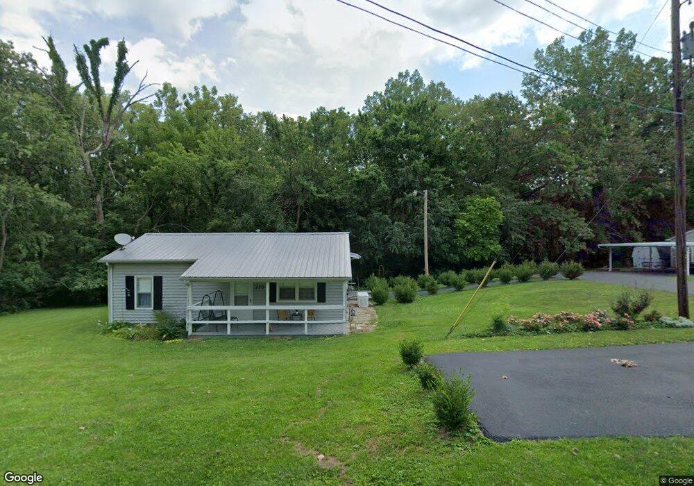
770 N Excelsior St Decatur, IL 62521
Estimated Value: $92,000 - $112,000
2
Beds
1
Bath
892
Sq Ft
$115/Sq Ft
Est. Value
About This Home
This home is located at 770 N Excelsior St, Decatur, IL 62521 and is currently estimated at $103,012, approximately $115 per square foot. 770 N Excelsior St is a home located in Macon County with nearby schools including Michael E. Baum Elementary School, Stephen Decatur Middle School, and Robertson Charter School.
Ownership History
Date
Name
Owned For
Owner Type
Purchase Details
Closed on
Nov 1, 2016
Sold by
Hadley Erin L and Hadley John
Bought by
Jacon Mary
Current Estimated Value
Purchase Details
Closed on
Oct 11, 2012
Sold by
Secretary Of Hud
Bought by
Aubert Erin L and Hadley John R
Purchase Details
Closed on
May 29, 2012
Sold by
Toone Robert Keith and Toone Sheila D
Bought by
Secretary Of Hud
Create a Home Valuation Report for This Property
The Home Valuation Report is an in-depth analysis detailing your home's value as well as a comparison with similar homes in the area
Home Values in the Area
Average Home Value in this Area
Purchase History
| Date | Buyer | Sale Price | Title Company |
|---|---|---|---|
| Jacon Mary | $65,000 | None Available | |
| Aubert Erin L | -- | None Available | |
| Secretary Of Hud | -- | None Available |
Source: Public Records
Tax History Compared to Growth
Tax History
| Year | Tax Paid | Tax Assessment Tax Assessment Total Assessment is a certain percentage of the fair market value that is determined by local assessors to be the total taxable value of land and additions on the property. | Land | Improvement |
|---|---|---|---|---|
| 2024 | $1,636 | $28,387 | $6,611 | $21,776 |
| 2023 | $1,481 | $26,377 | $6,143 | $20,234 |
| 2022 | $1,359 | $24,801 | $5,776 | $19,025 |
| 2021 | $1,235 | $23,512 | $5,476 | $18,036 |
| 2020 | $1,034 | $22,472 | $5,234 | $17,238 |
| 2019 | $1,034 | $22,472 | $5,234 | $17,238 |
| 2018 | $1,432 | $21,979 | $5,119 | $16,860 |
| 2017 | $1,412 | $21,708 | $5,056 | $16,652 |
| 2016 | $1,412 | $21,695 | $5,053 | $16,642 |
| 2015 | $1,337 | $21,416 | $4,988 | $16,428 |
| 2014 | $1,243 | $21,416 | $4,988 | $16,428 |
| 2013 | $1,241 | $21,416 | $4,988 | $16,428 |
Source: Public Records
Map
Nearby Homes
- 5527 Melwood Ave
- 5265 E Harbour
- 5135 Swashbuckler Ct
- Lot 4 Harbour Ct
- Lot 3 Harbour Ct
- (Lot 2) 410 N Excelsior St
- 5120 Swashbuckler Ct
- Lot 19 N Timberlake Ct
- (Lot 16) 320 N Timberlake Ct
- (Lot 17) 305 N Timberlake Ct
- (Lot 18) 325 N Timberlake Ct
- 690 N Cove Ct
- 317 N Country Club Rd
- 384 Greenway Ln
- 4504 E Spruce St
- 707 S Airport Rd
- 3948 E Grand Ave
- 92 N Country Club Rd
- 4606 Jamestown Ct
- 4468 Mount Vernon Place
- 770 N Excelsior St
- 760 Excelsior School Rd
- 771 N Excelsior St
- 761 N Excelsior St
- 773 N Excelsior St
- 771 N Excelsior St
- 741 N Excelsior St
- 741 N Excelsior St
- 751 Excelsior School Rd
- 731 N Excelsior St
- 749 N Barnett St
- 721 N Excelsior St
- 721 N Excelsior St
- 720 N Excelsior Sch
- 720 N Excelsior St
- 720 N Excelsior St
- 5655 Mill Rd
- 730 Excelsior School Rd
- 5574 E William Street Rd
- 5556 E William Street Rd