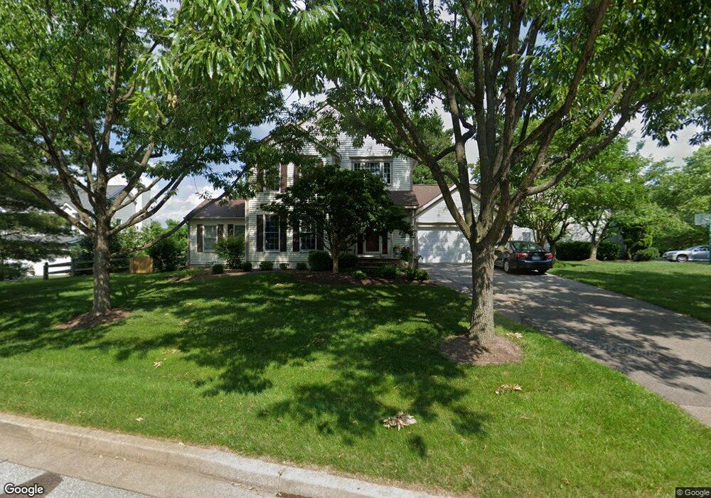
7700 Millstone Ct Ellicott City, MD 21043
Estimated Value: $776,445 - $971,000
--
Bed
3
Baths
2,642
Sq Ft
$332/Sq Ft
Est. Value
About This Home
This home is located at 7700 Millstone Ct, Ellicott City, MD 21043 and is currently estimated at $877,861, approximately $332 per square foot. 7700 Millstone Ct is a home located in Howard County with nearby schools including Rockburn Elementary School, Long Reach High School, and Trinity School.
Ownership History
Date
Name
Owned For
Owner Type
Purchase Details
Closed on
Feb 7, 1992
Sold by
Douglas Homes Inc
Bought by
Gray Steven J and Gray Jennifer P
Current Estimated Value
Home Financials for this Owner
Home Financials are based on the most recent Mortgage that was taken out on this home.
Original Mortgage
$90,000
Interest Rate
8.67%
Purchase Details
Closed on
Oct 21, 1991
Sold by
Rockburn Township Ltd Partnership
Bought by
Douglas Homes Inc
Create a Home Valuation Report for This Property
The Home Valuation Report is an in-depth analysis detailing your home's value as well as a comparison with similar homes in the area
Home Values in the Area
Average Home Value in this Area
Purchase History
| Date | Buyer | Sale Price | Title Company |
|---|---|---|---|
| Gray Steven J | $231,400 | -- | |
| Douglas Homes Inc | $240,000 | -- |
Source: Public Records
Mortgage History
| Date | Status | Borrower | Loan Amount |
|---|---|---|---|
| Closed | Gray Steven J | $90,000 |
Source: Public Records
Tax History Compared to Growth
Tax History
| Year | Tax Paid | Tax Assessment Tax Assessment Total Assessment is a certain percentage of the fair market value that is determined by local assessors to be the total taxable value of land and additions on the property. | Land | Improvement |
|---|---|---|---|---|
| 2025 | $7,792 | $640,500 | $0 | $0 |
| 2024 | $7,792 | $597,100 | $0 | $0 |
| 2023 | $7,294 | $553,700 | $201,900 | $351,800 |
| 2022 | $8,316 | $549,833 | $0 | $0 |
| 2021 | $8,358 | $545,967 | $0 | $0 |
| 2020 | $8,358 | $542,100 | $201,400 | $340,700 |
| 2019 | $8,309 | $538,667 | $0 | $0 |
| 2018 | $7,866 | $535,233 | $0 | $0 |
| 2017 | $7,791 | $531,800 | $0 | $0 |
| 2016 | -- | $517,033 | $0 | $0 |
| 2015 | -- | $502,267 | $0 | $0 |
| 2014 | -- | $487,500 | $0 | $0 |
Source: Public Records
Map
Nearby Homes
- 7712 Sandstone Ct
- 7718 Briarstone Ct
- 5908 Clear Ridge Rd
- 5816 Rockburn Woods Way
- 5317 Tims Ct
- 6641 Cambria Terrace
- 6210 Hunters Hollow Rd
- 5983 Glen Willow Way
- 5213 Talbots Landing
- 5905-2 Logans Way Unit 2
- 6021 Charles Crossing
- 6022 Maple Hill Rd
- 5948 Logans Way
- 5812 Lois Ln
- 5810 Lois Ln
- 8106 Wooded Glen Ct
- 5803 Lois Ln
- 7671 Stony Creek Ln Unit A
- 6209 Gatepost Way
- 6204 Briar Ct
- 7792 Rockburn Dr
- 7704 Millstone Ct
- 7788 Rockburn Dr
- 7705 Millstone Ct
- 7701 Millstone Ct
- 7708 Millstone Ct
- 7791 Rockburn Dr
- 7799 Rockburn Dr
- 7709 Millstone Ct
- 7712 Millstone Ct
- 7779 Rockburn Dr
- 7707 Graystone Ct
- 7795 Rockburn Dr
- 7806 Rockburn Dr
- 7711 Graystone Ct
- 7787 Rockburn Dr
- 7776 Rockburn Dr
- 7716 Millstone Ct
- 7783 Rockburn Dr
- 7803 Breakstone Ct