77087 Brock Rd Oakridge, OR 97463
Estimated payment $854/month
Highlights
- 1.19 Acre Lot
- Living Room
- Dining Room
- No HOA
- Laundry Room
- Family Room
About This Home
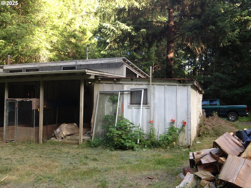
Fixer on Acreage — This property offers excellent potential for the right buyer. The home requires significant repairs and the grounds need clean-up, with primary value reflected in the land itself. Sold as-is; seller will make no repairs or remove any remaining personal property.Seller reports that the septic system is newer, and the well has been tested and is in good working condition. The home includes washer and dryer hookups in the laundry room. Outside, you’ll find a level yard featuring a 20x40 concrete pad and multiple outbuildings ideal for storage or workspac
Listing Agent
MORE Realty Brokerage Phone: 971-335-8697 License #200506310 Listed on: 11/05/2025

Home Details
Home Type
- Single Family
Est. Annual Taxes
- $1,381
Year Built
- Built in 1957
Lot Details
- 1.19 Acre Lot
- Property is zoned RR5
Home Design
- Fixer Upper
Interior Spaces
- 920 Sq Ft Home
- 1-Story Property
- Family Room
- Living Room
- Dining Room
- Laminate Flooring
- Laundry Room
Kitchen
- Free-Standing Range
- Dishwasher
Bedrooms and Bathrooms
- 2 Bedrooms
- 1 Full Bathroom
Schools
- Oakridge Elementary And Middle School
- Oakridge High School
Utilities
- No Cooling
- No Heating
- Well
- Electric Water Heater
- Septic Tank
Community Details
- No Home Owners Association
Listing and Financial Details
- Assessor Parcel Number 0948958
Map
Home Values in the Area
Average Home Value in this Area
Tax History
| Year | Tax Paid | Tax Assessment Tax Assessment Total Assessment is a certain percentage of the fair market value that is determined by local assessors to be the total taxable value of land and additions on the property. | Land | Improvement |
|---|---|---|---|---|
| 2025 | $1,381 | $108,860 | -- | -- |
| 2024 | $1,336 | $105,690 | -- | -- |
| 2023 | $1,336 | $102,612 | $0 | $0 |
| 2022 | $1,243 | $99,624 | $0 | $0 |
| 2021 | $1,208 | $96,723 | $0 | $0 |
| 2020 | $1,167 | $93,906 | $0 | $0 |
| 2019 | $1,123 | $91,171 | $0 | $0 |
| 2018 | $1,082 | $85,938 | $0 | $0 |
| 2017 | $1,034 | $85,938 | $0 | $0 |
| 2016 | $1,027 | $83,435 | $0 | $0 |
| 2015 | $1,008 | $81,005 | $0 | $0 |
| 2014 | $914 | $78,646 | $0 | $0 |
Property History
| Date | Event | Price | List to Sale | Price per Sq Ft |
|---|---|---|---|---|
| 11/14/2025 11/14/25 | Price Changed | $140,000 | -12.5% | $152 / Sq Ft |
| 11/05/2025 11/05/25 | For Sale | $160,000 | -- | $174 / Sq Ft |
Purchase History
| Date | Type | Sale Price | Title Company |
|---|---|---|---|
| Special Warranty Deed | $25,000 | Multiple | |
| Warranty Deed | $92,201 | Accommodation | |
| Trustee Deed | $92,201 | Fidelity National Title Insu |
Source: Regional Multiple Listing Service (RMLS)
MLS Number: 113148199
APN: 0948958
Disclaimer: Certain information contained herein is derived from information provided by parties other than Homes.com. All information provided is deemed reliable, but is not guaranteed to be accurate and should be independently verified.
![]() The content relating to real estate for sale on this web site comes in part from the IDX program of the RMLS™ of Portland, Oregon. Real estate listings held by brokerage firms other than Ten-X are marked with the RMLS™ logo, and detailed information about these properties includes the names of the listing brokers. Listing content is copyright © 2025 RMLS™, Portland, Oregon. Some properties which appear for sale on this web site may subsequently have sold or may no longer be available. All information provided is deemed reliable but is not guaranteed and should be independently verified.
The content relating to real estate for sale on this web site comes in part from the IDX program of the RMLS™ of Portland, Oregon. Real estate listings held by brokerage firms other than Ten-X are marked with the RMLS™ logo, and detailed information about these properties includes the names of the listing brokers. Listing content is copyright © 2025 RMLS™, Portland, Oregon. Some properties which appear for sale on this web site may subsequently have sold or may no longer be available. All information provided is deemed reliable but is not guaranteed and should be independently verified.
- 0 Bugle Loop Unit 22227729
- 0 Bugle Loop Unit 23406458
- 0 Bugle Loop Unit 741566274
- 0 Hiland Ranch Dr Unit 1500
- 76712 Bugle Loop
- 48489 Hiland Ranch Dr
- 77690 Brock Rd
- 48482 E Meadow Way
- 48391 Roberts Rd
- 0 Roberts Rd Unit 6800 20327112
- 48232 Westoak Rd
- 48399 E 1st St
- 48400 Railroad Ave
- 000 Jasper Dr
- 76232 Beech St
- 48117 E 2nd St
- 77220 Bar B L Ranch Rd
- 48121 Commercial St
- 48113 Commercial St
- 48294 Hills St