
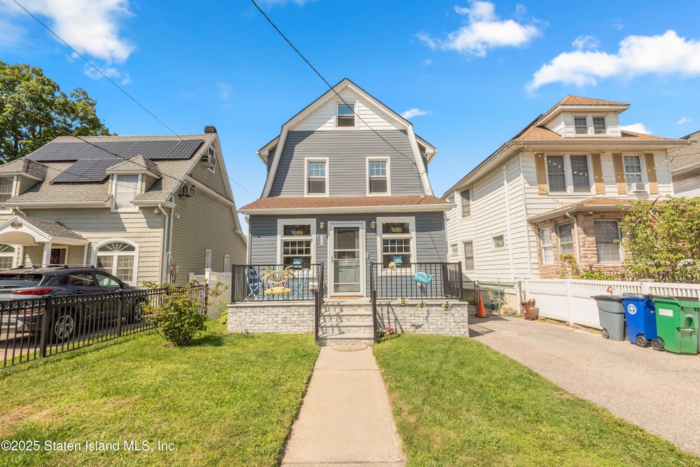


771 Delafield Ave Staten Island, NY 10310
West Brighton NeighborhoodEstimated payment $3,857/month
Total Views
8,425
2
Beds
1.5
Baths
1,240
Sq Ft
$524
Price per Sq Ft
Highlights
- Hot Property
- Colonial Architecture
- Eat-In Kitchen
- Susan E Wagner High School Rated A-
- 1 Car Detached Garage
- Walk-In Closet
About This Home
Welcome to this well-maintained two-bedroom, two-bath home that offers space, flexibility, and timeless charm. Originally built as a classic railroad-style three-bedroom, it has been thoughtfully converted to two generously sized bedrooms, creating a more open and functional layout. Spread across 2.5 levels, the home features a pitched attic space with great potential for future use. The unfinished basement provides ample room for storage, while a private driveway and detached one-car garage offer valuable off-street parking. Inside, enjoy bright and comfortable living areas—perfect for both everyday living and entertaining. Energy-efficient split units provide reliable heating and cooling throughout the home, ensuring year-round comfort and lower utility costs. Ideally located near schools, restaurants, shops, and public transportation, this home offers the perfect blend of convenience, comfort, and efficiency.
Home Details
Home Type
- Single Family
Est. Annual Taxes
- $5,255
Year Built
- Built in 1935
Lot Details
- 3,500 Sq Ft Lot
- Lot Dimensions are 35x100
- Back Yard
- Property is zoned R-3A
Parking
- 1 Car Detached Garage
- Off-Street Parking
Home Design
- Colonial Architecture
- Vinyl Siding
Interior Spaces
- 1,240 Sq Ft Home
- 2-Story Property
- Living Room with Fireplace
- Combination Kitchen and Dining Room
- Basement
Kitchen
- Eat-In Kitchen
- Microwave
- Freezer
- Dishwasher
Bedrooms and Bathrooms
- 2 Bedrooms
- Walk-In Closet
- Primary Bathroom is a Full Bathroom
Laundry
- Dryer
- Washer
Utilities
- Cooling Available
- Heating System Uses Natural Gas
- Hot Water Baseboard Heater
- 220 Volts
Listing and Financial Details
- Legal Lot and Block 0045 / 00229
- Assessor Parcel Number 00229-0045
Map
Create a Home Valuation Report for This Property
The Home Valuation Report is an in-depth analysis detailing your home's value as well as a comparison with similar homes in the area
Home Values in the Area
Average Home Value in this Area
Tax History
| Year | Tax Paid | Tax Assessment Tax Assessment Total Assessment is a certain percentage of the fair market value that is determined by local assessors to be the total taxable value of land and additions on the property. | Land | Improvement |
|---|---|---|---|---|
| 2025 | $5,243 | $37,080 | $9,098 | $27,982 |
| 2024 | $5,255 | $30,300 | $10,839 | $19,461 |
| 2023 | $4,986 | $25,949 | $10,145 | $15,804 |
| 2022 | $4,600 | $30,780 | $11,940 | $18,840 |
| 2021 | $4,667 | $32,460 | $11,940 | $20,520 |
| 2020 | $4,688 | $29,820 | $11,940 | $17,880 |
| 2019 | $4,502 | $27,060 | $11,940 | $15,120 |
| 2018 | $4,110 | $21,624 | $10,599 | $11,025 |
| 2017 | $3,859 | $20,400 | $11,940 | $8,460 |
| 2016 | $3,624 | $19,680 | $11,940 | $7,740 |
| 2015 | $3,460 | $19,620 | $9,960 | $9,660 |
| 2014 | $3,460 | $19,620 | $9,960 | $9,660 |
Source: Public Records
Property History
| Date | Event | Price | List to Sale | Price per Sq Ft |
|---|---|---|---|---|
| 12/04/2025 12/04/25 | For Sale | $649,999 | 0.0% | $524 / Sq Ft |
| 10/03/2025 10/03/25 | Pending | -- | -- | -- |
| 09/04/2025 09/04/25 | For Sale | $649,999 | -- | $524 / Sq Ft |
Source: Staten Island Multiple Listing Service
Purchase History
| Date | Type | Sale Price | Title Company |
|---|---|---|---|
| Bargain Sale Deed | $400,000 | None Available |
Source: Public Records
Mortgage History
| Date | Status | Loan Amount | Loan Type |
|---|---|---|---|
| Previous Owner | $320,000 | Purchase Money Mortgage |
Source: Public Records
About the Listing Agent
Simon's Other Listings
Source: Staten Island Multiple Listing Service
MLS Number: 2505181
APN: 00229-0045
Disclaimer: Certain information contained herein is derived from information provided by parties other than Homes.com. All information provided is deemed reliable, but is not guaranteed to be accurate and should be independently verified.
![]() Certain real estate listing data is provided by Staten Island MLS under its Internet Data Exchange program. This data is provided exclusively for consumers’ personal, non-commercial use and may only be used for identifying prospective properties consumers may be interested in purchasing or renting. Any other use of the data is hereby prohibited. Data deemed reliable but is not guaranteed accurate by Staten Island MLS and should be independently verified. Copyright 2025 Staten Island Multiple Listing Service, Inc. All rights reserved.
Certain real estate listing data is provided by Staten Island MLS under its Internet Data Exchange program. This data is provided exclusively for consumers’ personal, non-commercial use and may only be used for identifying prospective properties consumers may be interested in purchasing or renting. Any other use of the data is hereby prohibited. Data deemed reliable but is not guaranteed accurate by Staten Island MLS and should be independently verified. Copyright 2025 Staten Island Multiple Listing Service, Inc. All rights reserved.
Nearby Homes
- 28 Floyd St
- 233 Taylor St Unit 2
- 607 Delafield Ave Unit 2FL
- 150 Manor Rd Unit 2
- 243 Jewett Ave Unit 1
- 55 Purcell St Unit 2
- 360 Broadway
- 1924 Richmond Terrace Unit B
- 1924 Richmond Terrace Unit A
- 966 Clove Rd Unit J2
- 43 Dongan Ave Unit 1
- 2268 Richmond Terrace Unit 1st Floor
- 6 Kelly Pkwy Unit 2
- 5 Kelly Pkwy Unit 202
- 18 Kelly Pkwy
- 21 Lord Ave Unit ID1290853P
- 156 Morningstar Rd
- 30 Kelly Pkwy Unit 2
- 17 Avenue E Unit 504
- 17 Avenue E Unit 506