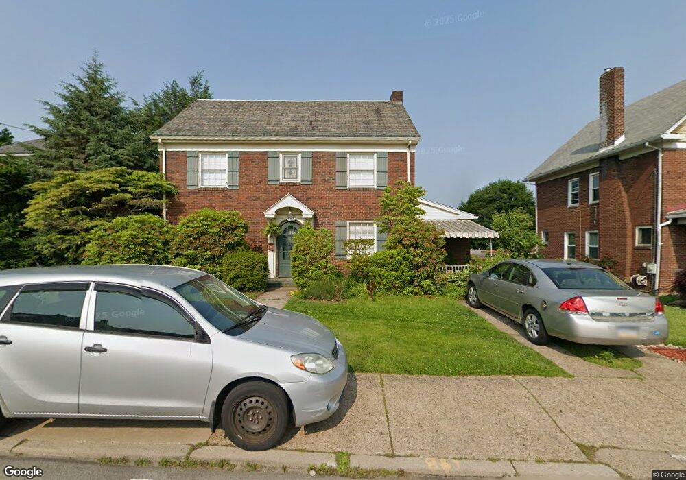
771 Freeport Rd New Kensington, PA 15068
Estimated Value: $97,877 - $222,000
--
Bed
--
Bath
--
Sq Ft
8,233
Sq Ft Lot
About This Home
This home is located at 771 Freeport Rd, New Kensington, PA 15068 and is currently estimated at $166,219. 771 Freeport Rd is a home located in Westmoreland County with nearby schools including Mary Queen of Apostles School.
Ownership History
Date
Name
Owned For
Owner Type
Purchase Details
Closed on
Nov 10, 2016
Sold by
Prorok Shayle L
Bought by
Miller Richard J
Current Estimated Value
Purchase Details
Closed on
Dec 23, 2015
Sold by
Prorok Shayle L
Bought by
Prorok Shayle L
Create a Home Valuation Report for This Property
The Home Valuation Report is an in-depth analysis detailing your home's value as well as a comparison with similar homes in the area
Home Values in the Area
Average Home Value in this Area
Purchase History
| Date | Buyer | Sale Price | Title Company |
|---|---|---|---|
| Miller Richard J | $90,000 | None Available | |
| Prorok Shayle L | -- | None Available |
Source: Public Records
Tax History Compared to Growth
Tax History
| Year | Tax Paid | Tax Assessment Tax Assessment Total Assessment is a certain percentage of the fair market value that is determined by local assessors to be the total taxable value of land and additions on the property. | Land | Improvement |
|---|---|---|---|---|
| 2025 | $4,224 | $26,460 | $4,030 | $22,430 |
| 2024 | $4,185 | $26,460 | $4,030 | $22,430 |
| 2023 | $3,960 | $26,460 | $4,030 | $22,430 |
| 2022 | $3,839 | $26,460 | $4,030 | $22,430 |
| 2021 | $3,752 | $26,460 | $4,030 | $22,430 |
| 2020 | $3,672 | $26,460 | $4,030 | $22,430 |
| 2019 | $3,580 | $26,460 | $4,030 | $22,430 |
| 2018 | $3,527 | $26,460 | $4,030 | $22,430 |
| 2017 | $3,474 | $26,460 | $4,030 | $22,430 |
| 2016 | $3,474 | $26,460 | $4,030 | $22,430 |
| 2015 | $3,474 | $26,460 | $4,030 | $22,430 |
| 2014 | $3,338 | $26,460 | $4,030 | $22,430 |
Source: Public Records
Map
Nearby Homes
- 1400 Orchard Ave
- 1024 Knollwood Rd
- 1308 Taylor Ave
- 1038 Manor Rd
- 533 Freeport Rd
- 1719 Freeport Rd
- 1520 Woodmont Ave
- 1312 Woodmont Ave
- 1717 Ridge Ave
- 1515 Woodmont Ave
- 1735 Kimball Ave
- 1506 Victoria Ave
- 1741 Freeport Rd Unit U
- 1218 Woodmont Ave
- 1240 Victoria Ave
- 1521 Victoria Ave
- 1802 Kimball Ave
- 1802 Alcoa Dr
- 1809 Kimball Ave
- 1512 Kenneth Ave
- 775 Freeport Rd
- 707 Freeport Rd
- 781 Freeport Rd
- 705 Freeport Rd
- 0 Freeport Rd Unit 1027840
- 709 Freeport Rd
- 920 North St
- 916 North St
- 658 Kimball Ave
- 662 Kimball Ave
- 656 Kimball Ave
- 783 Freeport Rd
- 912 North St
- 654 Kimball Ave
- 666 Kimball Ave
- 652 Kimball Ave
- 910 North St
- 908 North St Unit B
- 908 North St Unit 910
- 648 Kimball Ave